Cauquenes River in Desembocadura
Context
The Cauquenes River basin at its mouth is one of the best-instrumented watersheds in Chile in terms of eco-hydrological data, as it contains information on all hydrometeorological variables with good spatial representation. Notably, the database includes soil properties, soil water content, and transpiration data for different types of vegetation. This makes it an ideal condition for the implementation of process-based models, which have already been deployed by the (CR)2 team. It is therefore possible to analyze different water security scenarios under hypothetical land cover conditions (such as the expansion of forest plantations, restoration of native forest, agricultural expansion, and population adaptations), which has begun to be explored in some studies (Galleguillos et al., 2021).
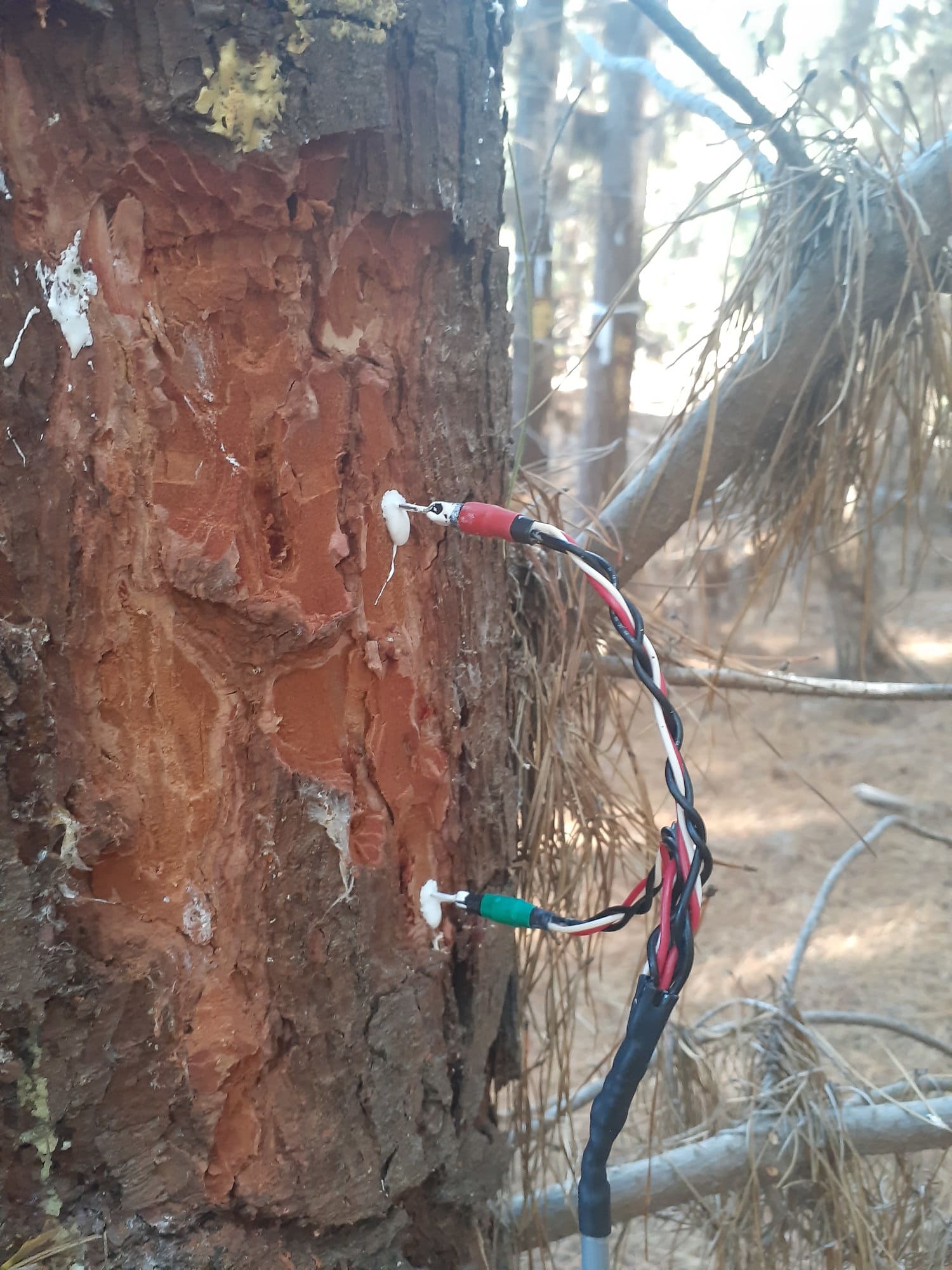
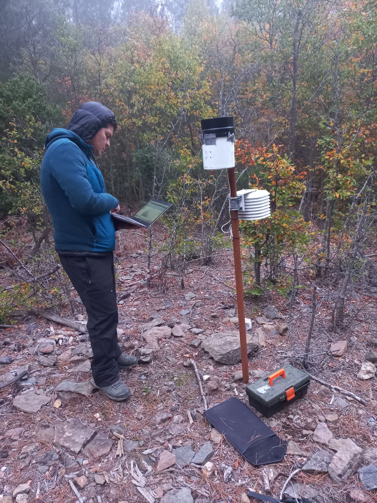
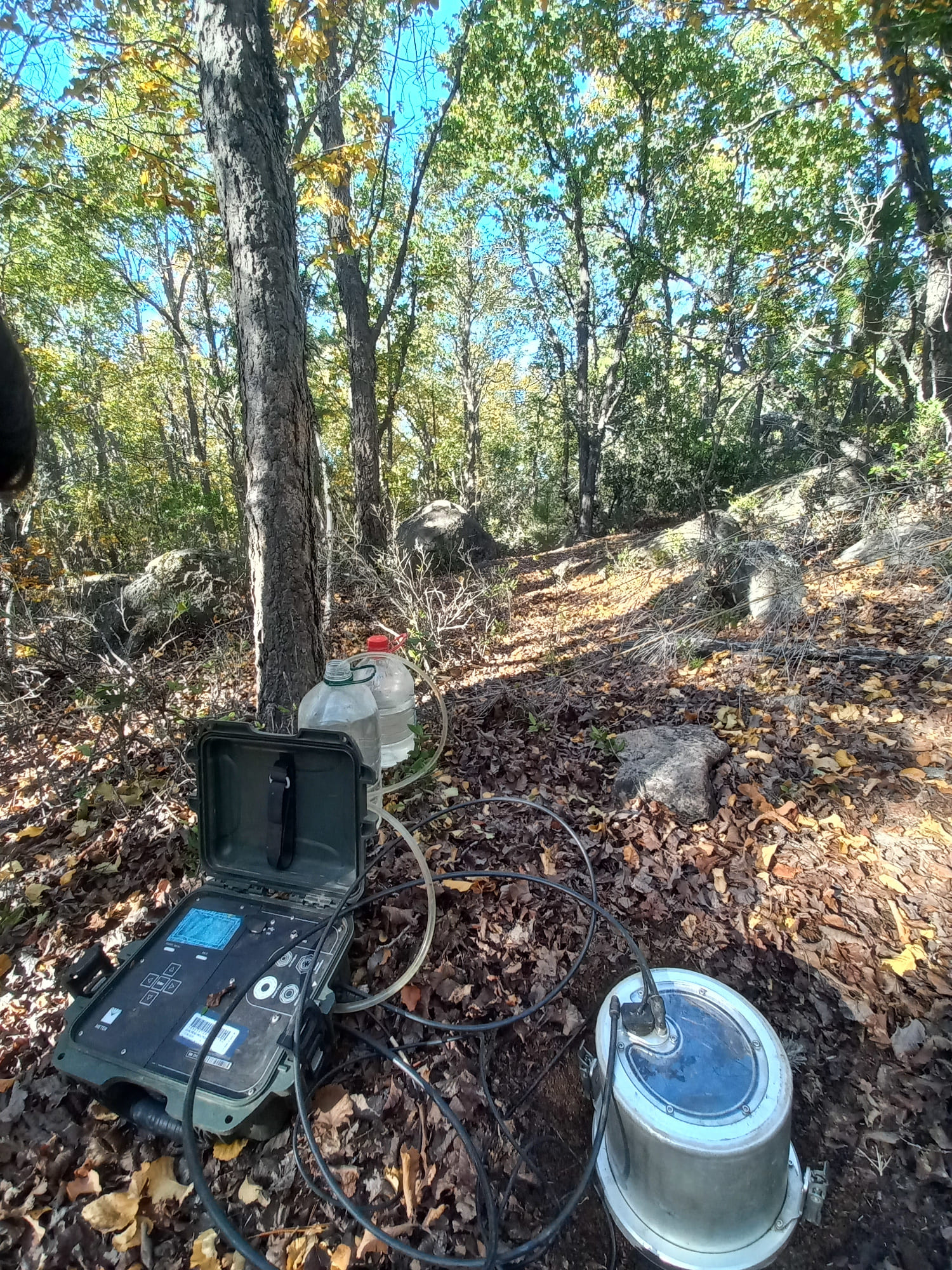
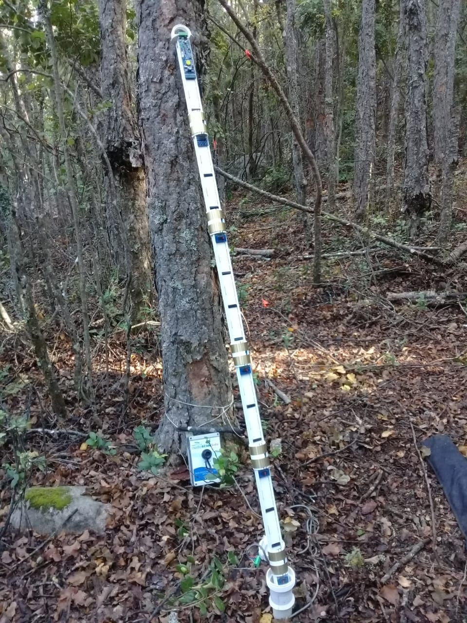
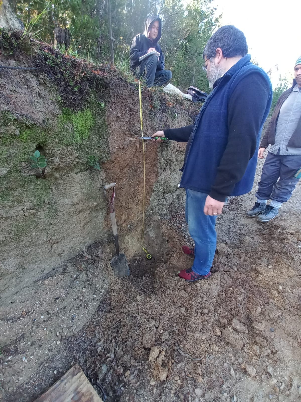
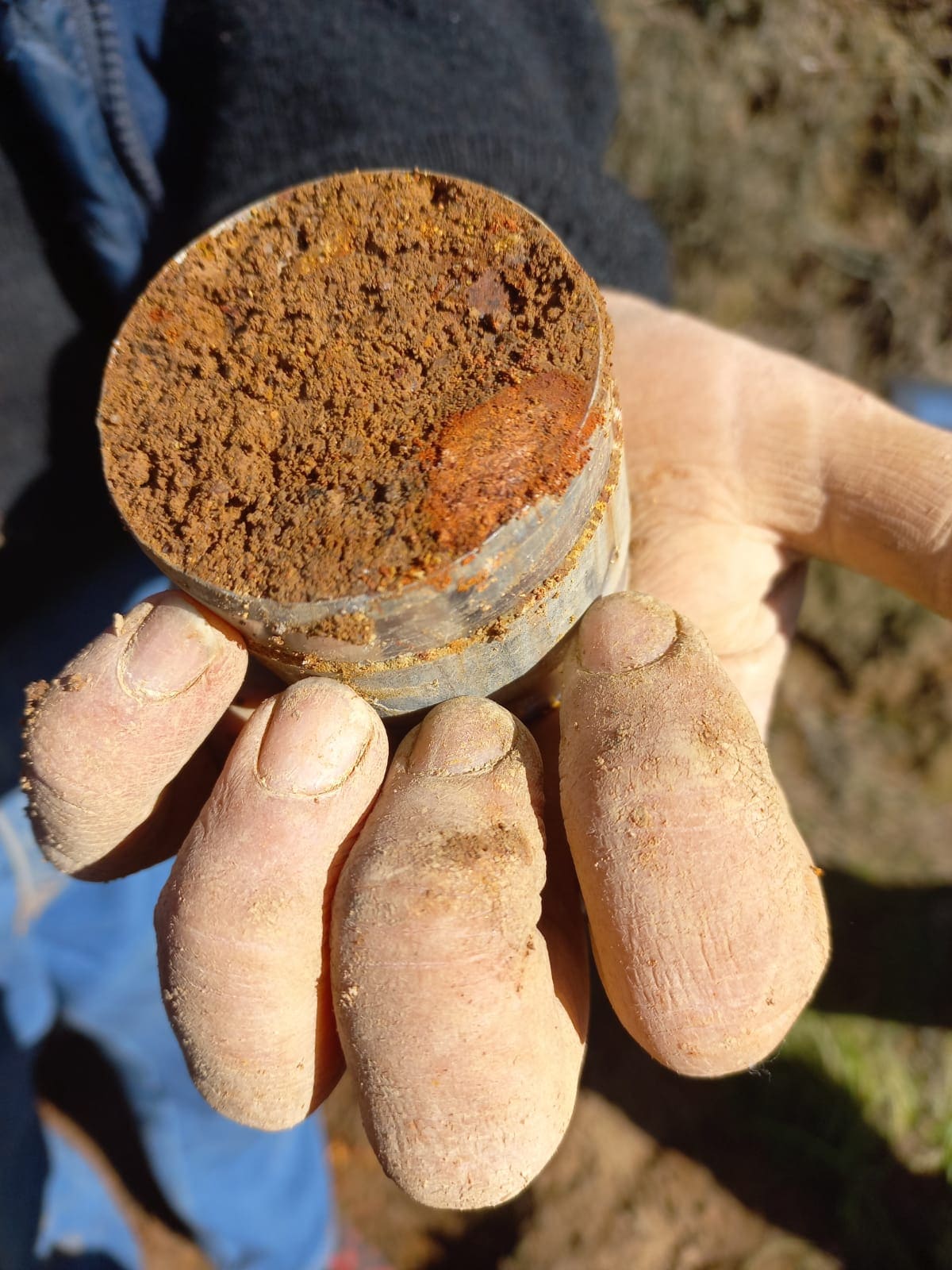
Figure 1. Sap flow sensor in a pine tree; rain gauge; saturated hydraulic conductivity meter in the soil; soil water content probe; soil profile description; cylinder sampled from a soil profile.
Description
The Cauquenes River basin is located between the Maule Region to the north and Ñuble Region to the south, precisely between latitudes 35.6° and 36.4°S, and longitudes 72° and 72.8°W. The basin primarily includes part of the coastal range and the intermediate depression.
This watershed is defined based on the location of the Cauquenes River at its mouth (35.900°S, 72.050°W). The total contributing area is 1750 km², including the El Arenal stream (DGA, 2013), with elevations ranging from 108 to 736 m above sea level, an average slope of 88.9 m/km, and an annual average rainfall of 934 mm (CR2MET). Forests, including native forests and forest plantations, cover 41.5% of the basin. Administratively, the basin includes parts of the Cauquenes and Chanco communes in the Maule Region and the Quirihue commune in the Ñuble Region.
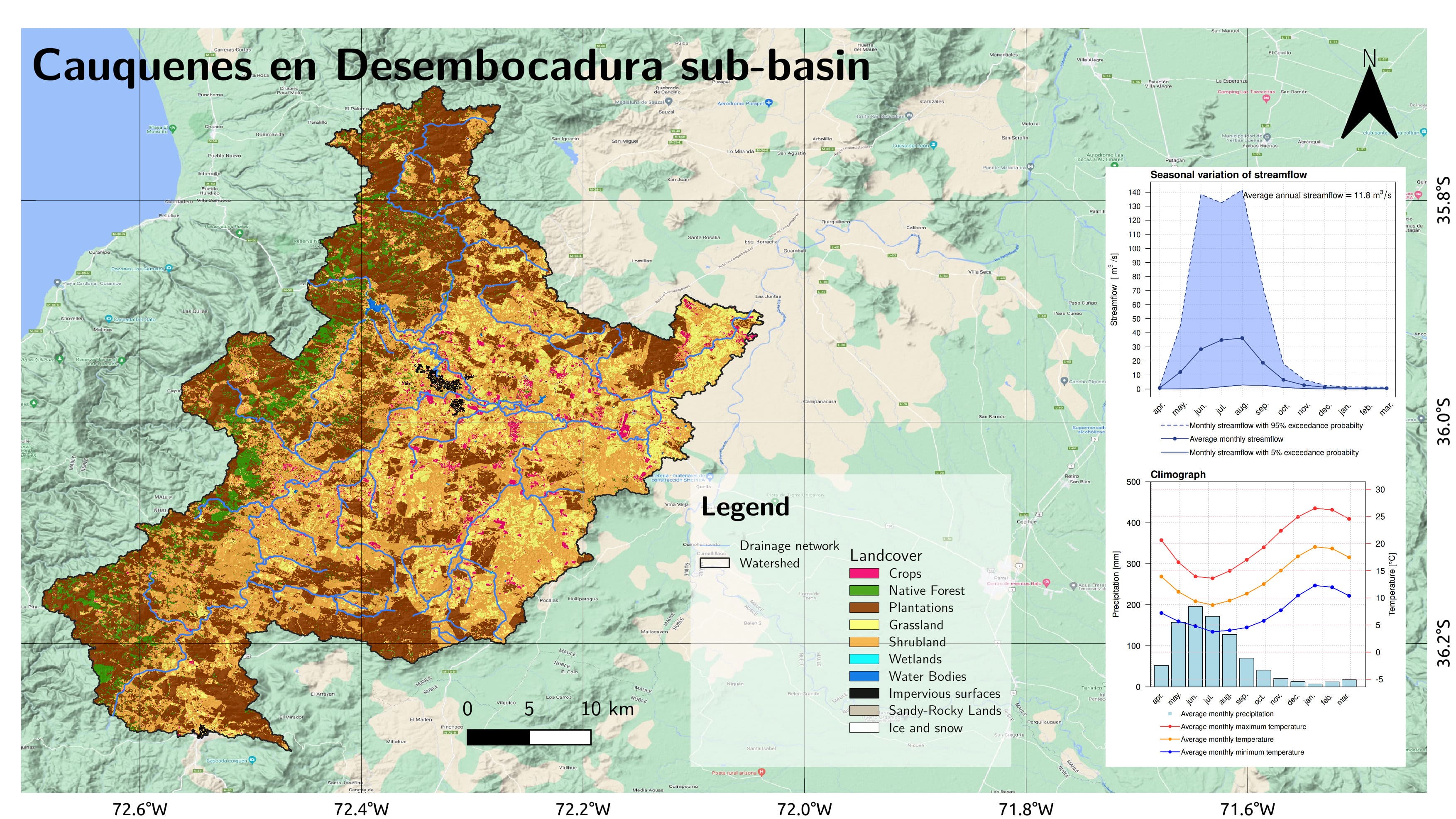
Figure 2. Cauquenes Basin.
Economic Activity
The economy of the region is mainly based on agriculture, supplying raw materials for the wine industry. Wine represents 82% of the region’s total exports, followed by the production of sawn or roughly-hewn wood, which accounts for only 11% (Datawheel, 2018). The study area, being close to the Chilean coast, is characterized by a Mediterranean climate with winter rainfall (Csb) according to the Köppen classification (Spatial Data Infrastructure Chile, 2016), with a balance of temperatures and precipitation that supports the wine industry in Cauquenes. The area has a long history of winemaking, as vineyards and wine production began during the Conquest period, with iconic varieties such as the País grape](https://biblioteca.inia.cl/bitstream/handle/20.500.14001/6905/NR42178.pdf?sequence=6&isAllowed=y) ([Soto, 2015](https://www.redalyc.org/pdf/4695/469546445006.pdf)). Today, there has been an increase in large wine companies in Cauquenes, acquiring extensive land due to the area’s optimal conditions for wine production[. However, the presence of large wine companies has also led to conflicts over water use among resource users in the basin*.
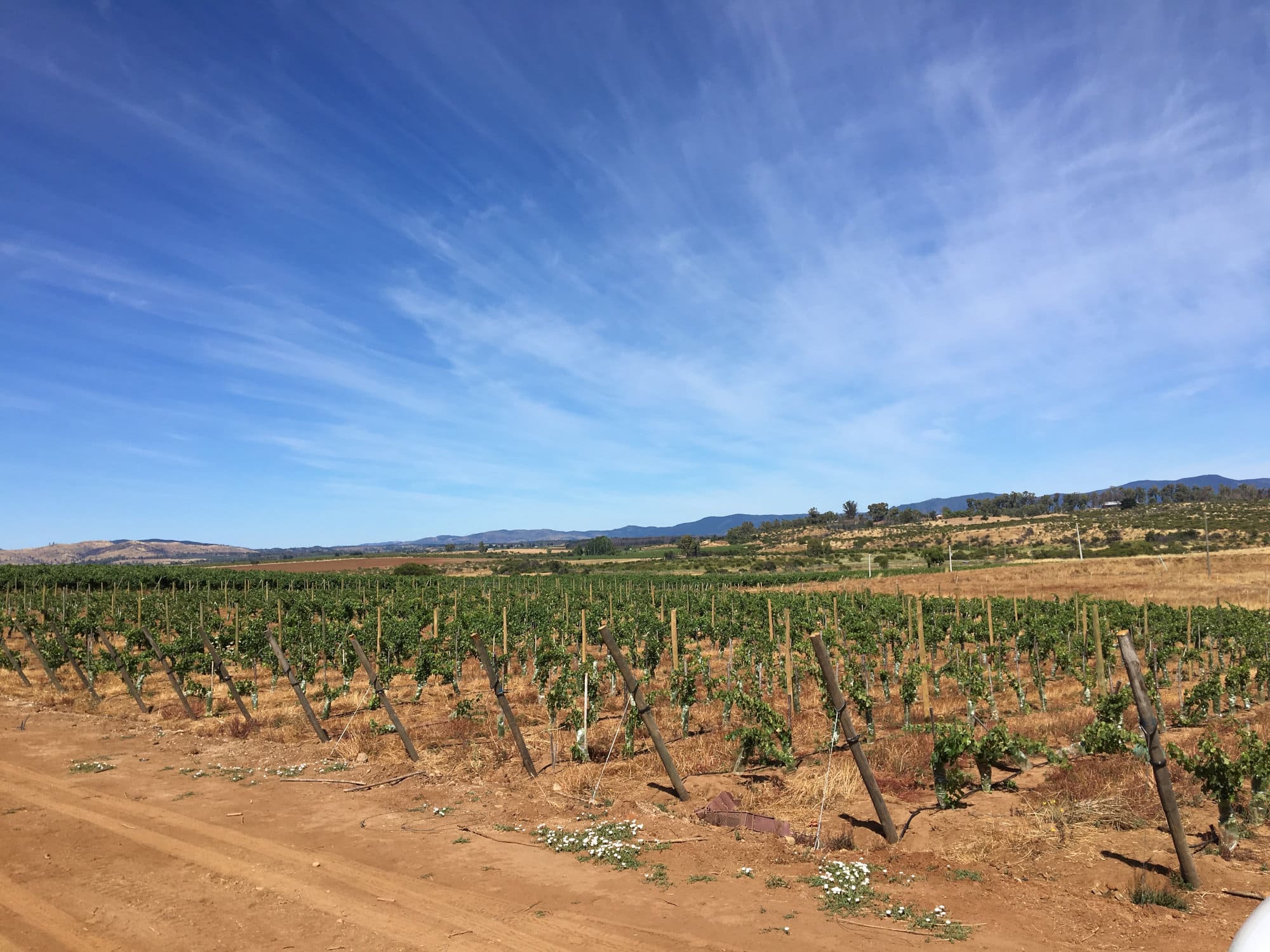

Figure 3. Vineyards where soil analyses and soil water content monitoring have been conducted.
Hydrology
The main rivers in the basin are the Cauquenes River, Rosal River, Tutuvén River, and San Juan River. Additionally, there are several streams, such as Doña Toribia, Paso Honda, Quinicaven, Liucura, Camarico, Los Coipos, Culenco, Las Garzas, Paso Ancho, Tutuvén, Tobalguen, and El Cajón.
The Cauquenes River receives waters from the San Juan and Tutuvén rivers, among other streams, and then flows into the Perquilauquén River.
Climate
Rainfall ranges from 600 to 900 mm per year, mostly concentrated between May and August, resulting in cold and humid winters with few frosts, while summers are dry and hot, with air temperatures in the hottest month exceeding 22°C (Beck et al., 2018).
According to the Köppen-Geiger climate classification, during the period 1980-2016, the basin has only one type of climate: Csb (Beck et al., 2018), where the entire basin experiences a prolonged dry, mild summer climate.
For the period 2071-2100, a new climate type is expected to emerge: Csa (Beck et al., 2018), which differs from Csb in that summers will be even warmer in the intermediate depression.
In the context of the Cauquenes River basin at its mouth, the following climate types have been identified for the present and future periods:
- Csb: Temperate climate with dry, warm summers. Similar to the Csa climate, this type has dry, warm summers, but temperatures may be slightly more moderate. The rainy season is concentrated in winter, and drought is more pronounced in summer. This climate is common in coastal regions with maritime influence.
- Csa: Temperate climate with dry, warm summers. This type of climate is characterized by dry seasons during the warmest months of the year. Summers are generally warm with high temperatures, while winters are milder. Rainfall is concentrated in the winter months, and drought is more pronounced in summer. This climate is common in coastal regions with maritime influence, where the ocean moderates temperatures and contributes to the seasonal pattern of rainfall. Vegetation adapted to these climate patterns typically includes species capable of withstanding seasonal drought and high summer temperatures.
These climate categories are essential for understanding and describing the region’s climatic characteristics, both in the present and future projections. Analyzing climate trends is crucial for decision-making regarding planning and adaptation to potential climate changes.
Figure 4. Köppen-Geiger climate classification map of the Cauquenes Basin at its mouth for the present period (1980–2016) and the future (2071-2100). Source: Beck et al., 2018.
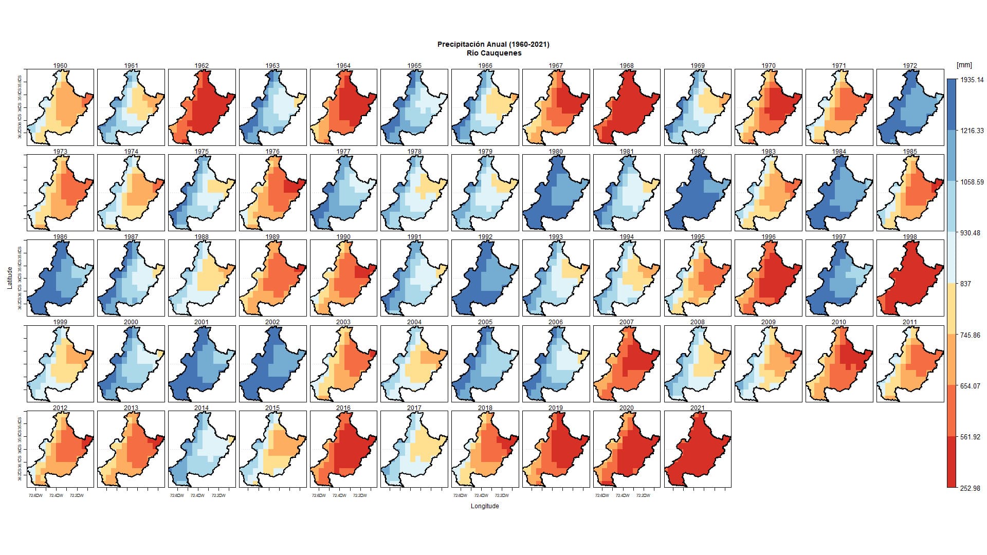
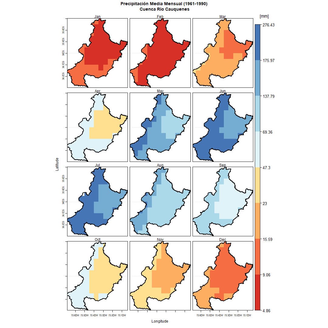
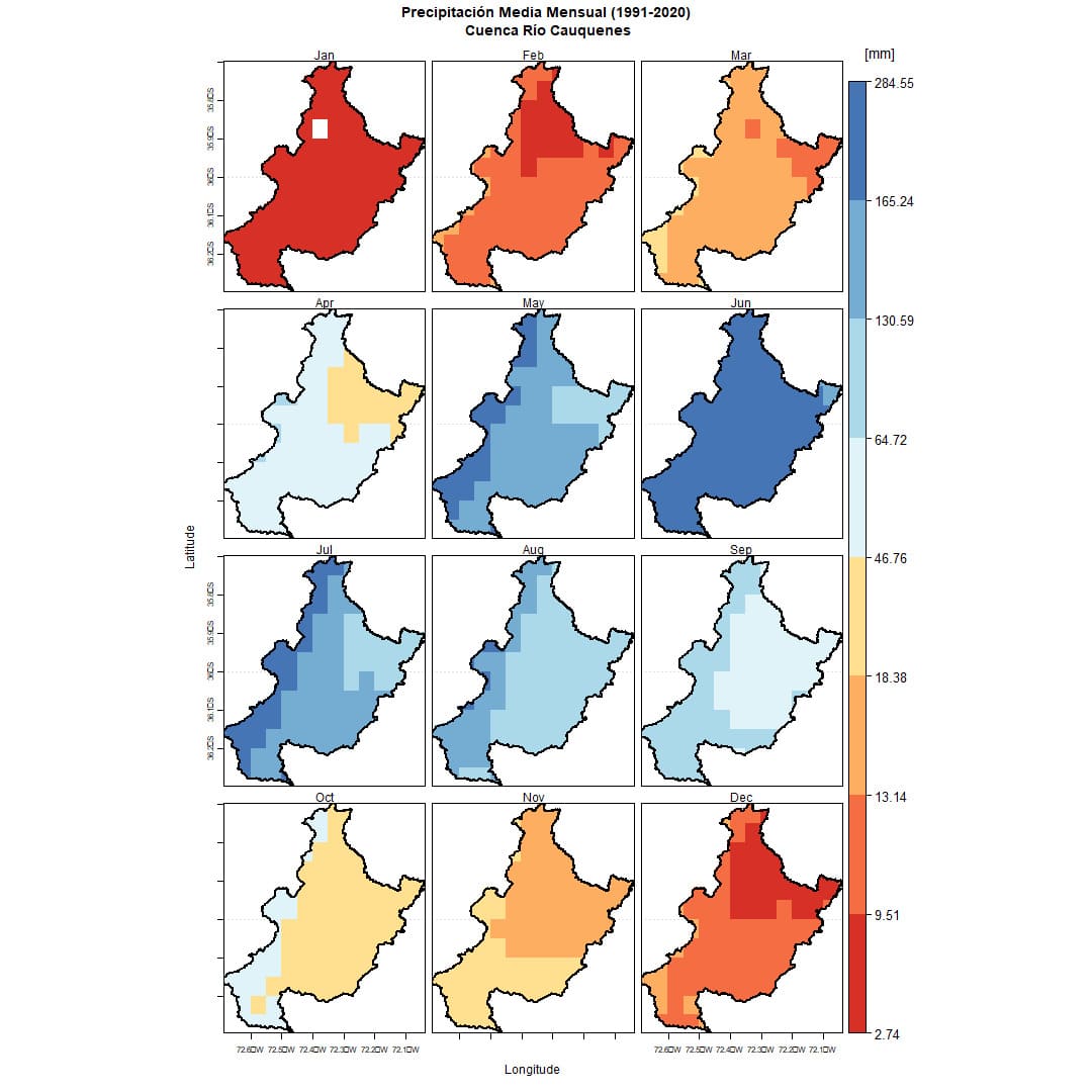
Figure 5. Spatial distribution of precipitation in the Cauquenes River Basin. Created using CR2METv2.5 data.
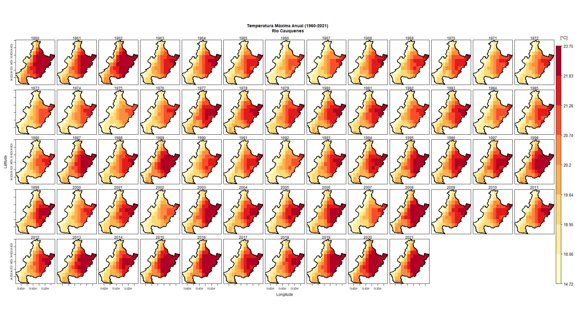
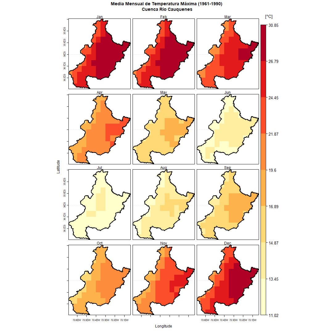
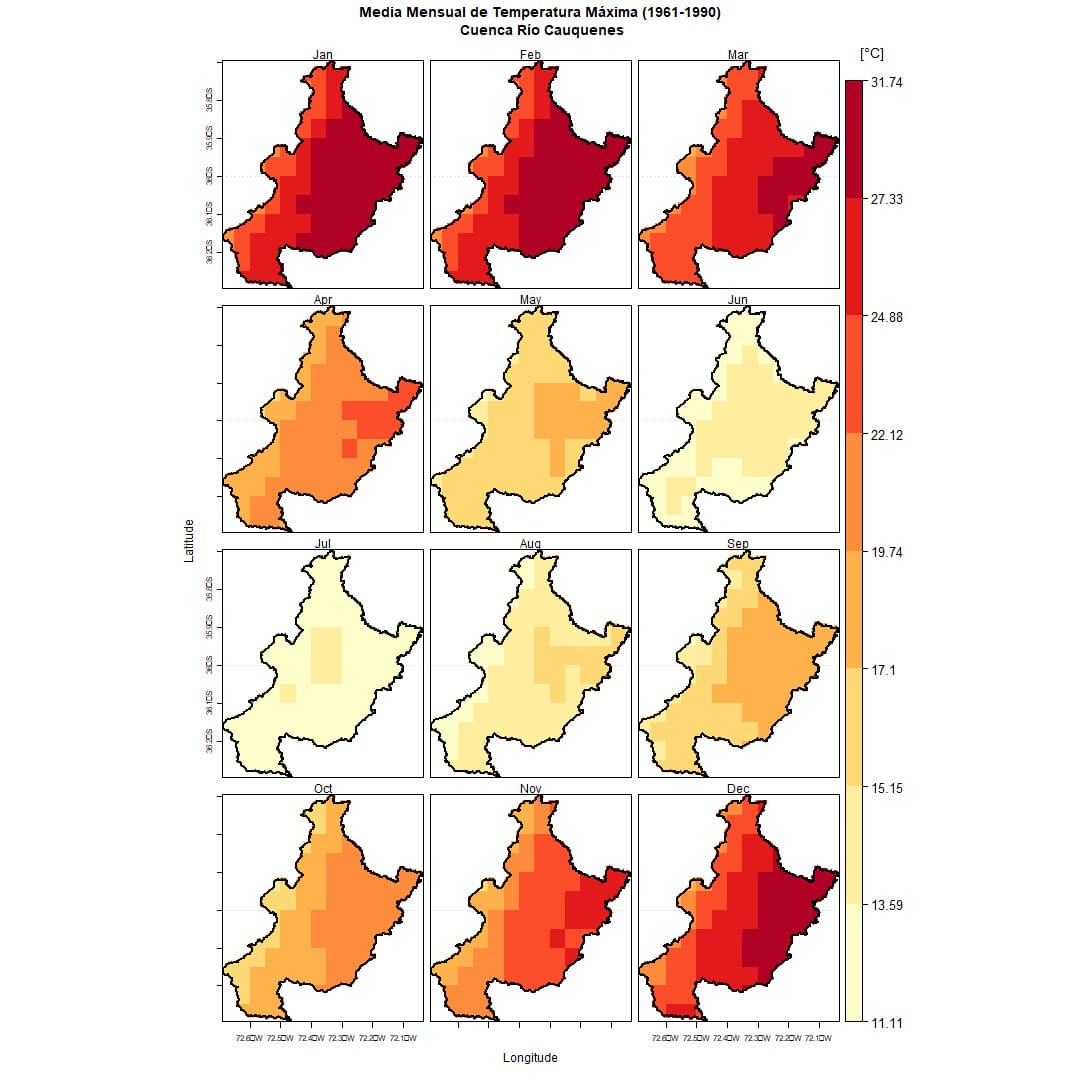
Figure 6. Spatial distribution of Maximum Temperature in the Cauquenes River Basin. Prepared based on CR2METv2.5 data.
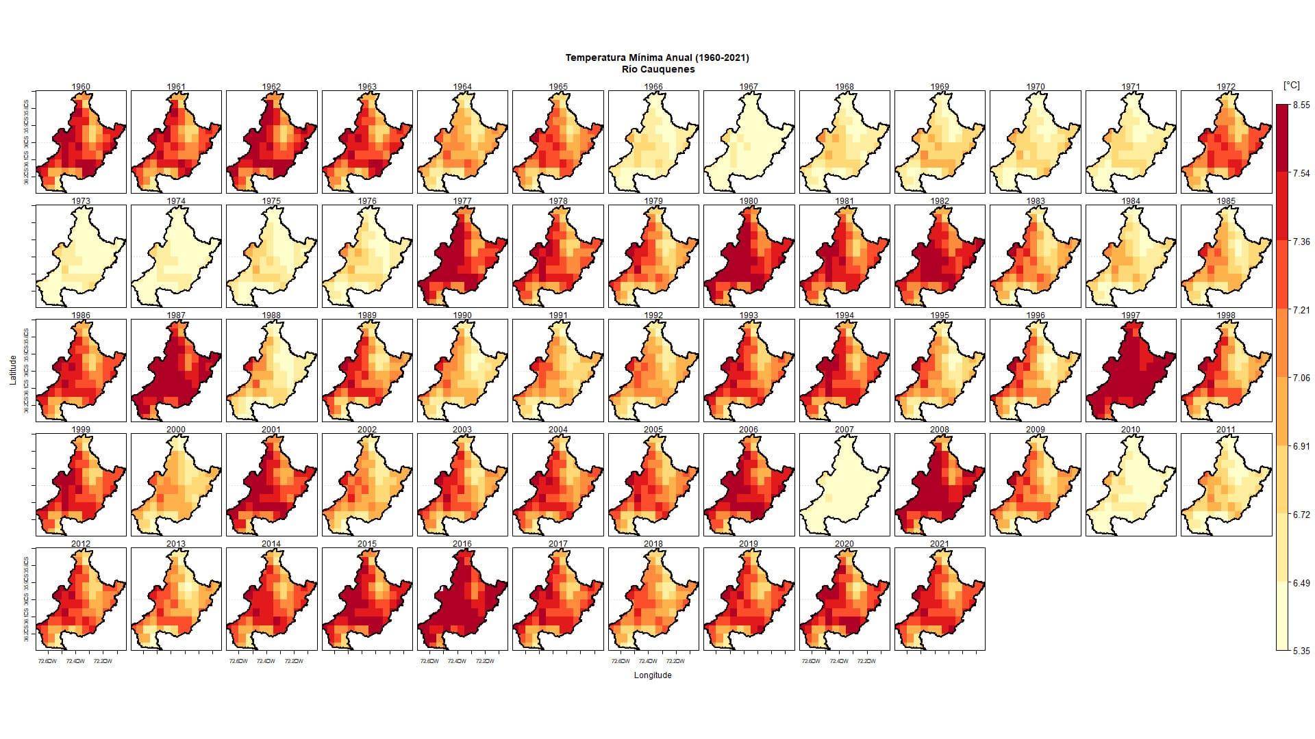
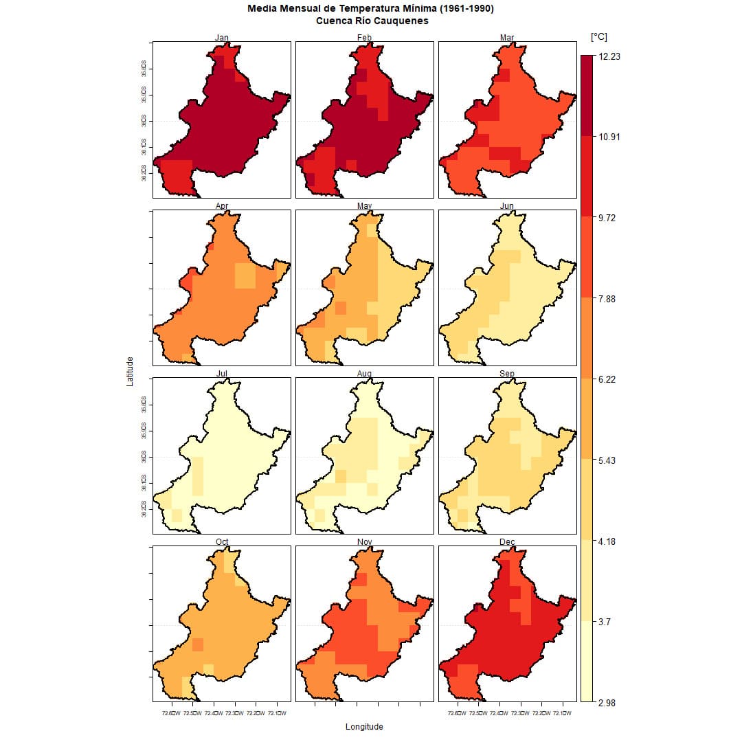
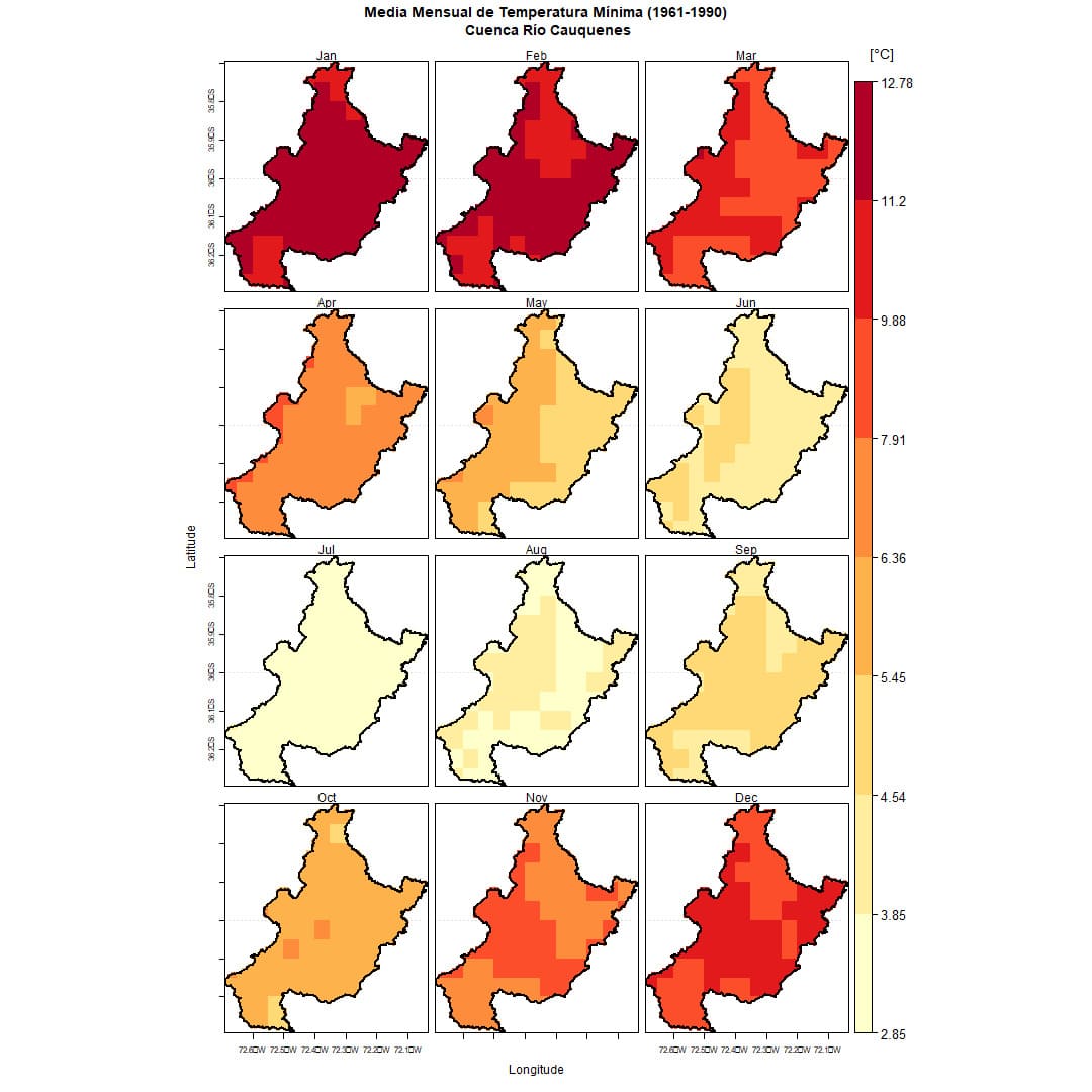
Figure 7. Spatial distribution of Minimum Temperature in the Cauquenes River Basin. Prepared based on CR2METv2.5 data.
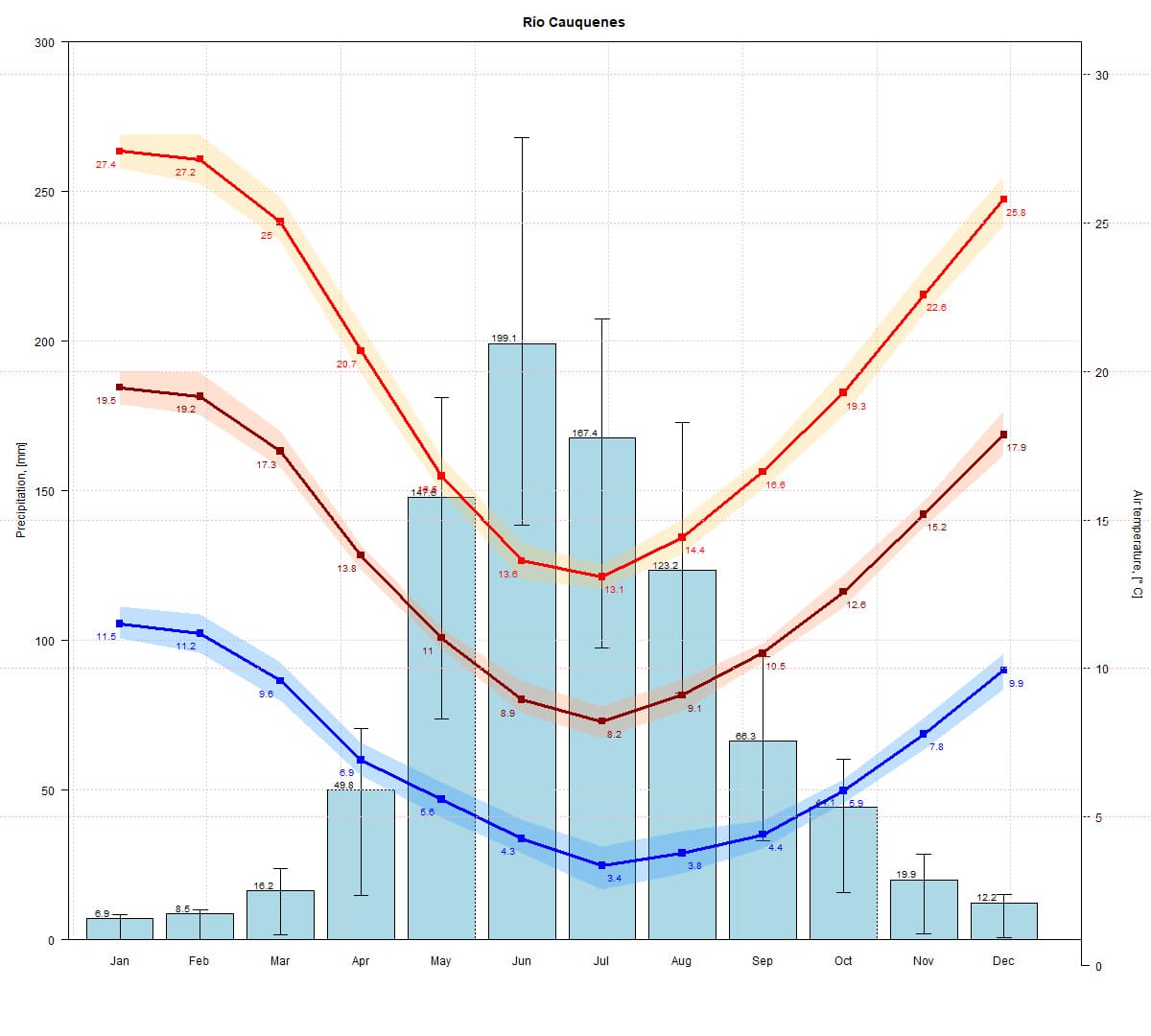
Figure 8. Climograph of the Cauquenes River Basin. Prepared based on CR2METv2.5 data.
Land Use
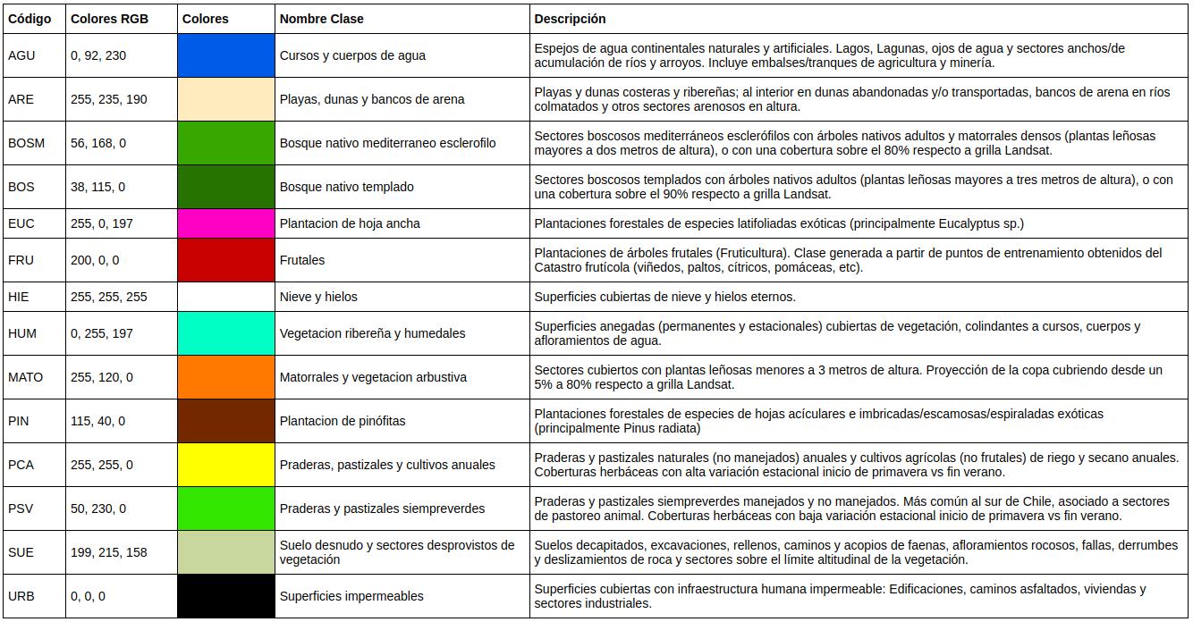
The basin has 30% of its area covered by shrubs and bush vegetation, 26% by grasslands, pastures, and annual crops, and 19% is covered by pine plantations due to the significant agricultural activity in the region.
Figure 9. Land use map of the Cauquenes River Basin at the Mouth. Source: Ceballos et al. (2021) y Galleguillos et al. (2024).
Table 1. Descriptive table of land cover in the Cauquenes River Basin at the Mouth.
Vegetation Zones
According to Luebert and Pliscoff (2018), the natural vegetation in the region corresponds to Mediterranean thorny forest formations of Acacia caven - Lithrea caustica, Mediterranean sclerophyllous forest of Lithrea caustica - Peumus boldus, coastal deciduous Mediterranean forest of Nothofagus glauca - Azara petiolaris, and coastal deciduous Mediterranean forest of Nothofagus glauca - Persea lingue.
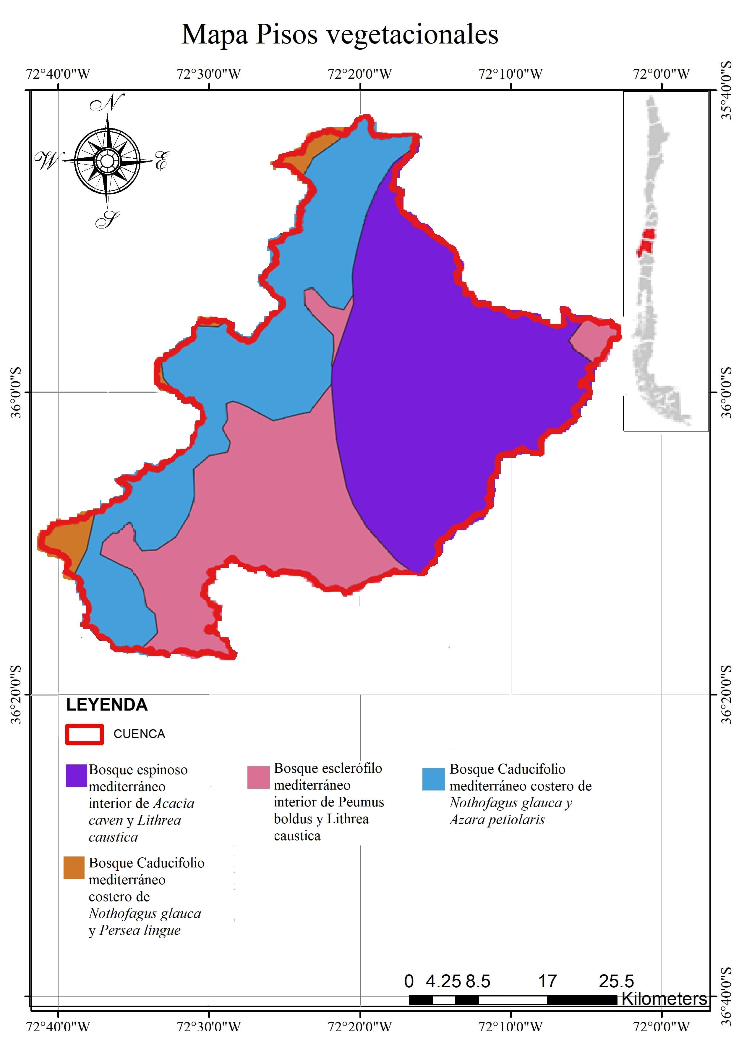
Figure 10. Map of Vegetation Zones (Luebert and Pliscoff, 2018) in the Cauquenes River Basin at the Mouth.
The land cover as of 2015, according to Zhao et al. (2016), shows that 36% of the basin area is covered by forest plantations (mainly Pinus radiata), and 6% is covered by native forest. However, the predominant cover is shrubland, accounting for 42% of the basin’s area.
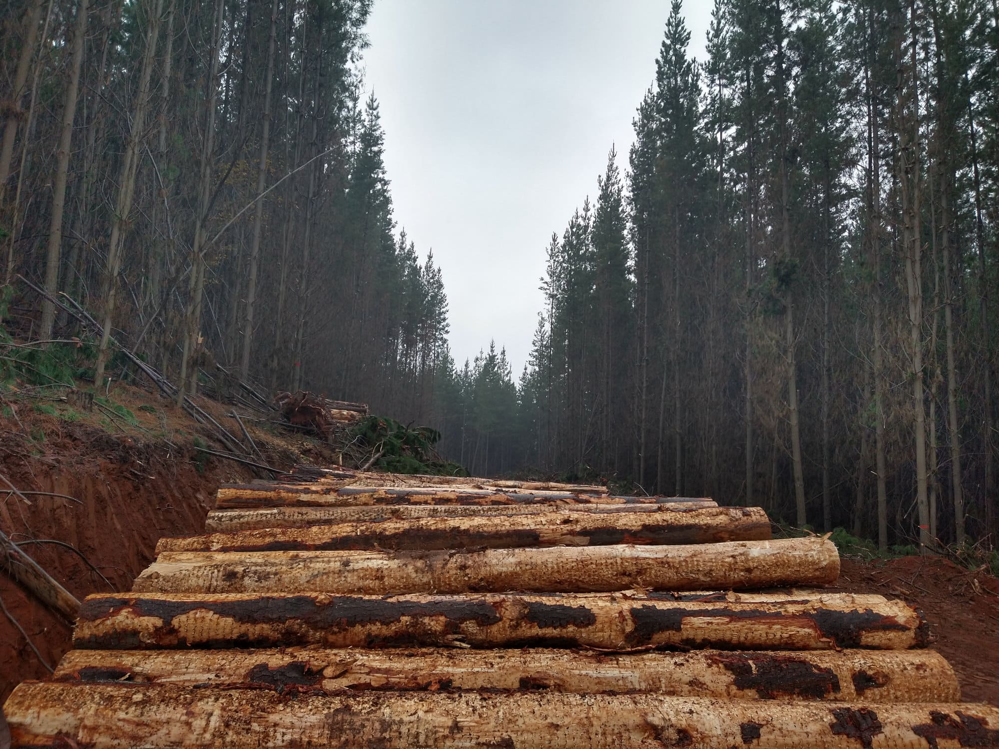
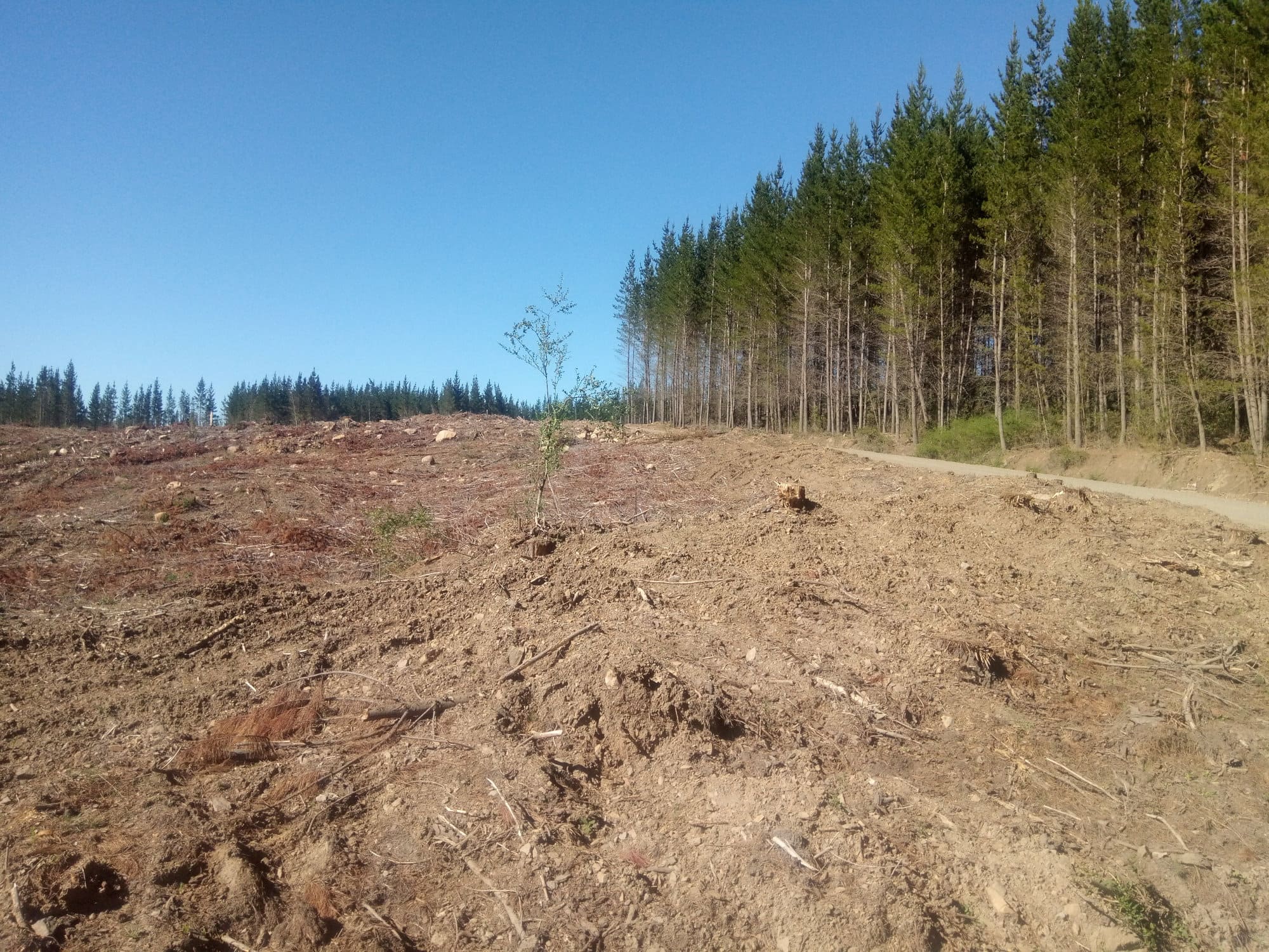
Figure 11. Photographs of Pinus radiata forest plantations in the basin.
Regarding the native forest, it is represented by the Maulino coastal forest, mainly composed of hualo (Nothofagus glauca) and other species like avellano (Gevuina avellana), radal (Lomatia hirsuta), maquicillo (Azara petiolaris), roble (Nothofagus obliqua), lingue (Persea lingue), and in some areas, they share canopy dominance with ruil (Nothofagus alessandrii) (Luebert and Pliscoff, 2018). This forest is part of one of the 36 biodiversity hotspots due to its high level of endemism and loss of original vegetation caused by human activity (Arnold et al., 2009; CONAMA, 2008). Currently, this forest is limited to small patches adjacent to forest plantations (Bustamante et al., 2005) due to past land-use changes for agriculture and the expansion of forest plantations, which fragmented them in space. The constant drought of the last 11 years and increasing forest fires (González et al., 2020) pose a constant threat to these native forest areas. The situation is particularly concerning with patches of forest that have burned in recent years, where pine regeneration has been abundant, hindering the recovery of native species *. For these reasons, this forest is classified as vulnerable (VU) to endangered (EN) according to the IUCN Red List criteria in its wild state (Alaniz et al., 2016).
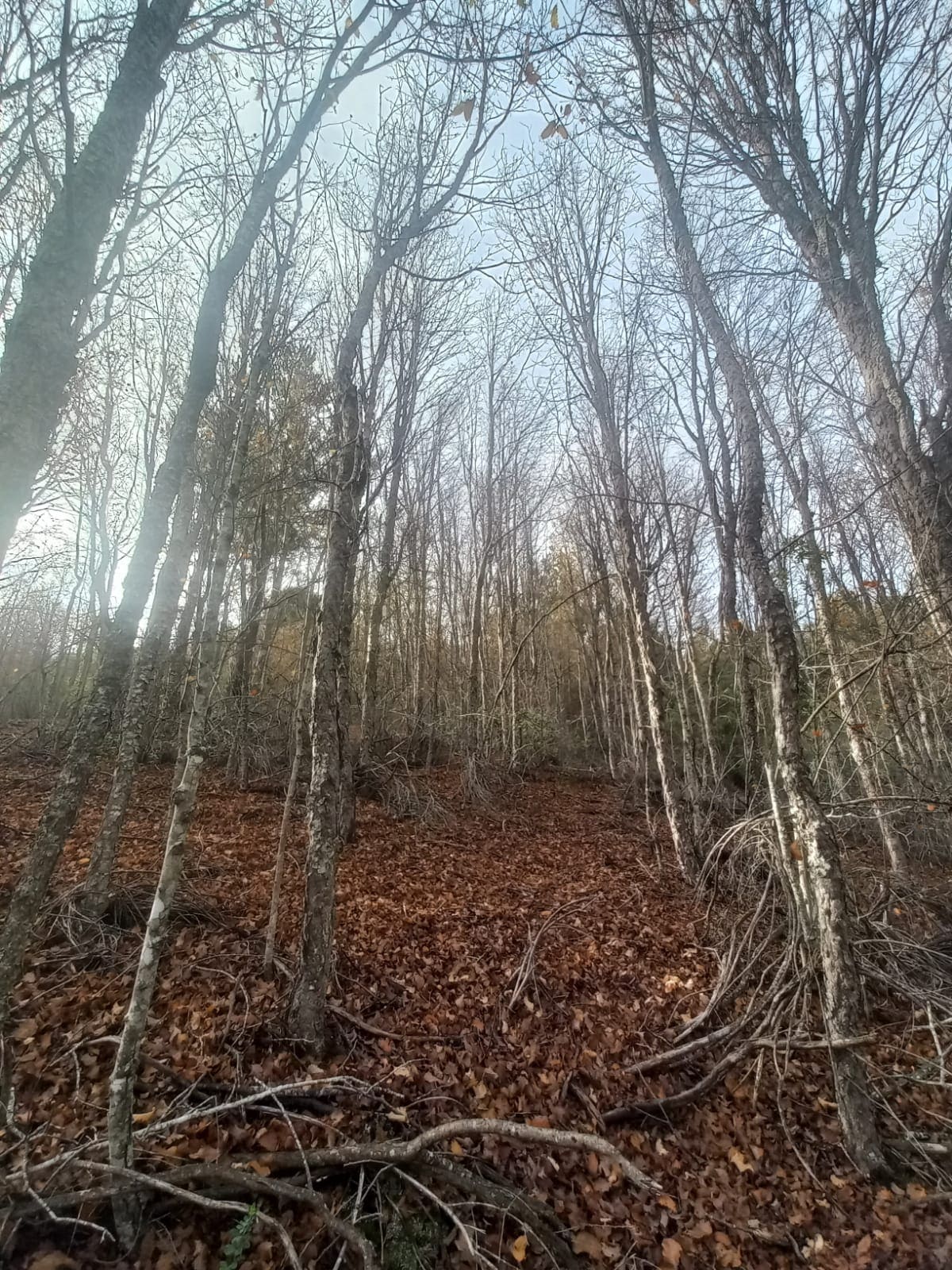
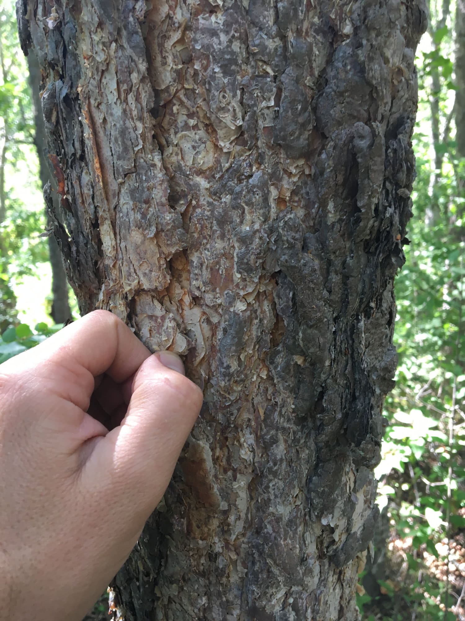
Figure 12. The left photo shows a Nothofagus glauca forest in winter when the trees are leafless, and the right photo shows the bark of Nothofagus glauca.
The current thorny shrubland or Espinal present in the basin is a disclimax condition resulting from extensive degradation processes of the native formations in the region (Armesto and Pickett, 1985, Fierro et al., 1998) of the Mediterranean thorny forest of Acacia caven and Lithrea caustica and the Mediterranean sclerophyllous forest of Lithrea caustica and Peumus boldus (Luebert and Pliscoff, 2018). The main uses of the Espinal are for charcoal production and livestock feeding (Fierro et al., 1998).
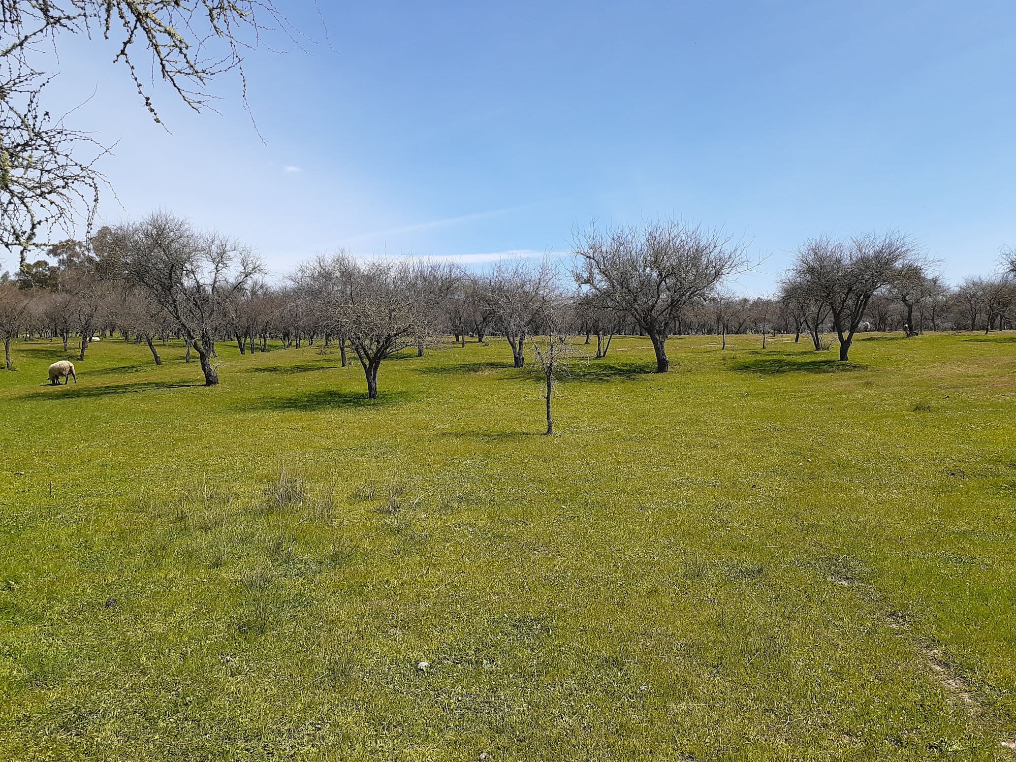
Figure 13. Photo of the thorny shrubland of Acacia caven at the end of the winter period.
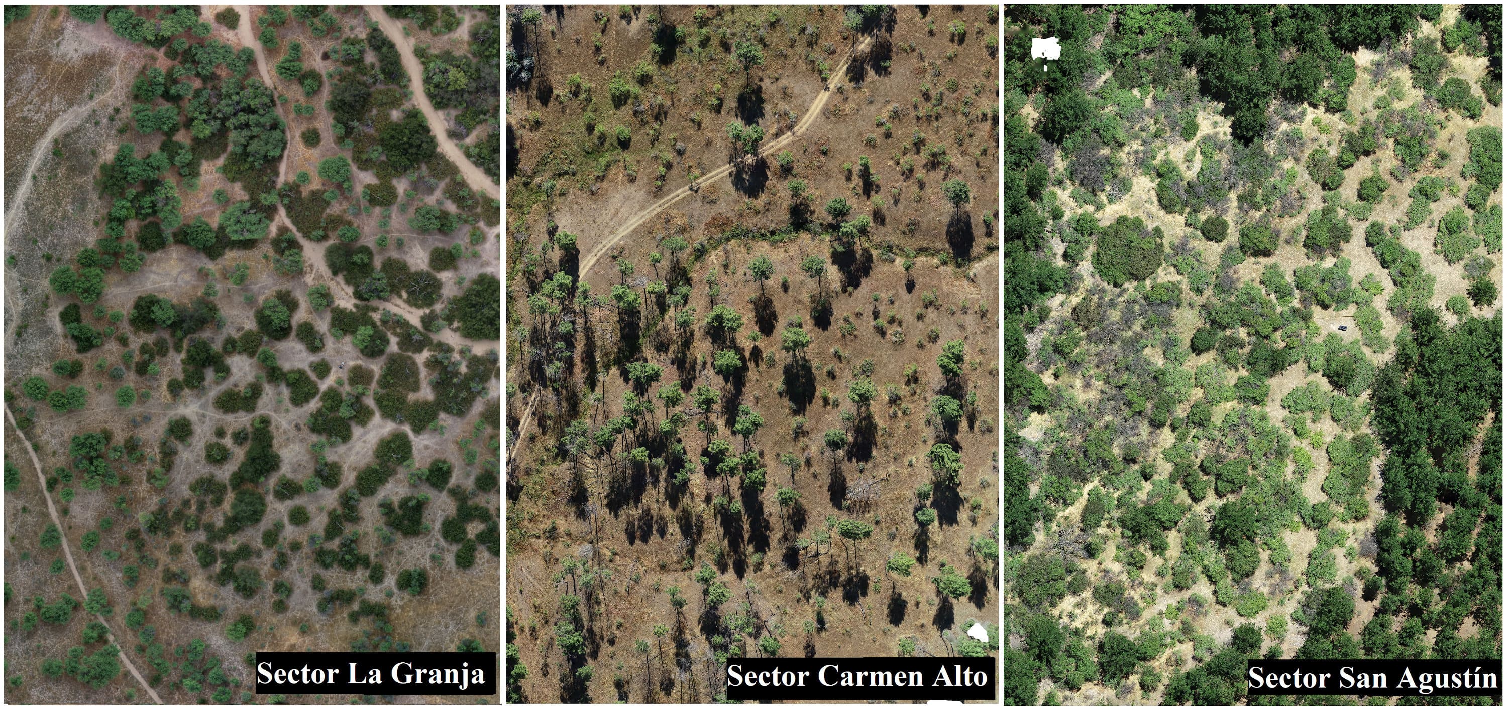
Figure 14. Drone images of shrubland in different parts of the basin.
Geomorphology
The geomorphology of the area is determined by one of the three macro forms of Chile’s relief, shaped by the Coastal Range and the remaining terraces generated by the Maule River. In the area, two formations of the Coastal Range converge: one made up of granitic rocks, which are the continuation of the northern granitic batholith, and the other of metamorphic rocks, marking the beginning of the basement that extends southward (Bravo, 2001; Luzio et al., 2010; Martínez, 2004). The weathering of the rocks in the Coastal Range has generated residual soils, in areas with steep slopes, which are sensitive to water erosion (CIREN, 1997). A large portion of the soils associated with the Coastal Range have been assigned use capacities VI and VII, meaning that many of them are covered with pine (Pinus radiata) and eucalyptus (Eucalyptus sp.) plantations. On the other hand, soils formed in sedimentation valleys have use capacities I, II, and III, making them suitable for agricultural activities (Luzio et al., 2010; MINVU, 2012).
Soil Types
According to the Agrological Study of the VII Region conducted by CIREN (1997), the soils in the study area are Alfisols in the Coastal Range, with well-developed soils derived from granitic and metamorphic rocks, Alfisols on ancient alluvial terraces, with varied mineralogy and less depth, and Inceptisols on recent alluvial deposits with variable depth and drainage depending on landscape position. Except for soils formed in sedimentation valleys, the area mainly presents three soil Associations: Cauquenes, Pocilla, and Constitución, all of which are Alfisols formed in situ from granitic rock in the case of Cauquenes (this has clay texture throughout the profile) and from metamorphic rock in the other two cases (Pocilla is clay loam on the surface and silty clay at depth, while Constitución is sandy clay loam on the surface and silty clay loam at depth). Also, in a smaller portion of the basin, the Treguaco Association can be observed, which is the only Inceptisol in the area formed in situ, with silty clay loam texture throughout the profile, and the Maule Series, which is an Alfisol derived mainly from granitic sedimentary materials with sandy clay loam texture on the surface and clay at depth. Its depth ranges from deep (>100 cm) in valley areas to moderately deep (50 to 75 cm) on the slopes of the Coastal Range (CIREN, 1997), although weathering can reach great depths in some areas, resulting in equally deep soils of more than 100 cm.
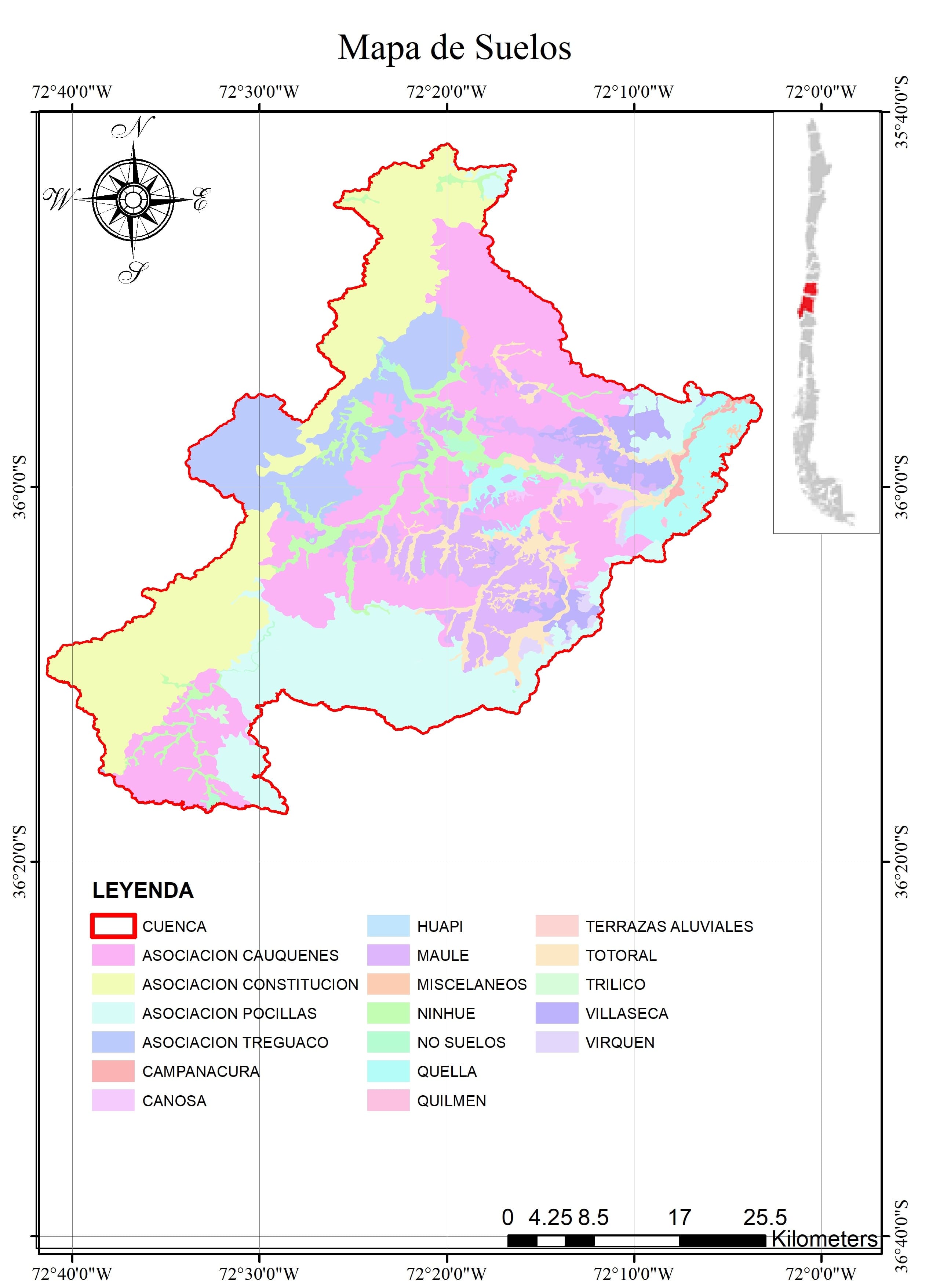
Figure 16. Map of the soil series and associations described by CIREN (1997) in the Cauquenes River basin.
Water Resources
The main rivers present in the basin are the Cauquenes River, Rosal River, Tutuvén River, and San Juan River. In addition, there are a series of streams such as Doña Toribia, Paso Honda, Quinicaven, Liucura, Camarico, Los Coipos, Culenco, Las Garzas, Paso Ancho, Tutuvén, Tobalguen, and El Cajón.
The Cauquenes River receives waters from the San Juan and Tutuvén rivers, among other streams, and then flows into the Perquilauquén River.
The most important reservoir in the basin is the Tutuvén, which is used for agricultural purposes, with a capacity of 13,000,000 m³ and a potential irrigation area of 2200 ha.
The water situation in Cauquenes can be put into context with the Maule Region, where many areas face constant drought declarations. Currently, Cauquenes has an active decree declaring it a water-scarce area, along with other nearby municipalities (Ministry of Public Works, 2018). Figure 1 shows the study area, highlighting the drainage network and the stations of interest for the present study.
Several studies have been conducted in the basin regarding water resources and vegetation cover. One such study is by Galleguillos et al. (2021), which examines the combined effect of climate change and land use change in the Cauquenes basin. These authors concluded that forestation with exotic pines will intensify the reduction in water production by generating lower flows, while scenarios in which native forests are maintained or reforested would result in higher flows in a future period between 2037–2050. Similarly, Little et al. (2009) studied the Cauquenes basin in the Arrayán and Purapel areas, analyzing the effect of vegetation cover on flows for the periods 1991–2000 compared to 1981–1990. They concluded that the increase in forest plantations and the decrease in native forest cover lead to a reduction in summer runoff.
Precipitation Intensity-Duration Curves
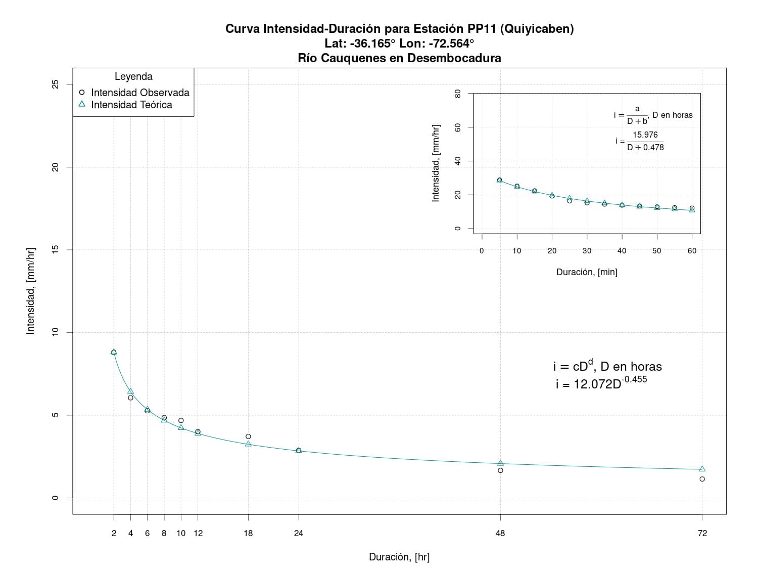
Figure 17. Intensity-Duration Curve for the Quiyicaben Station (PP11).
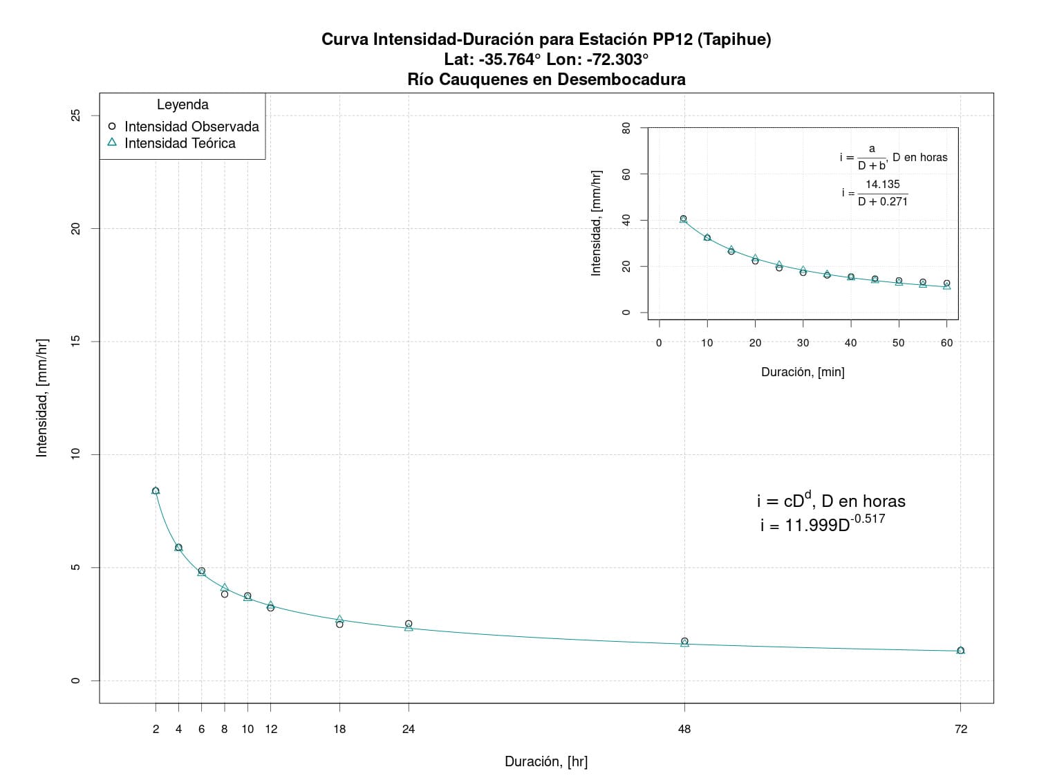
Figure 18. Intensity-Duration Curve for the Tapihue Station (PP12).
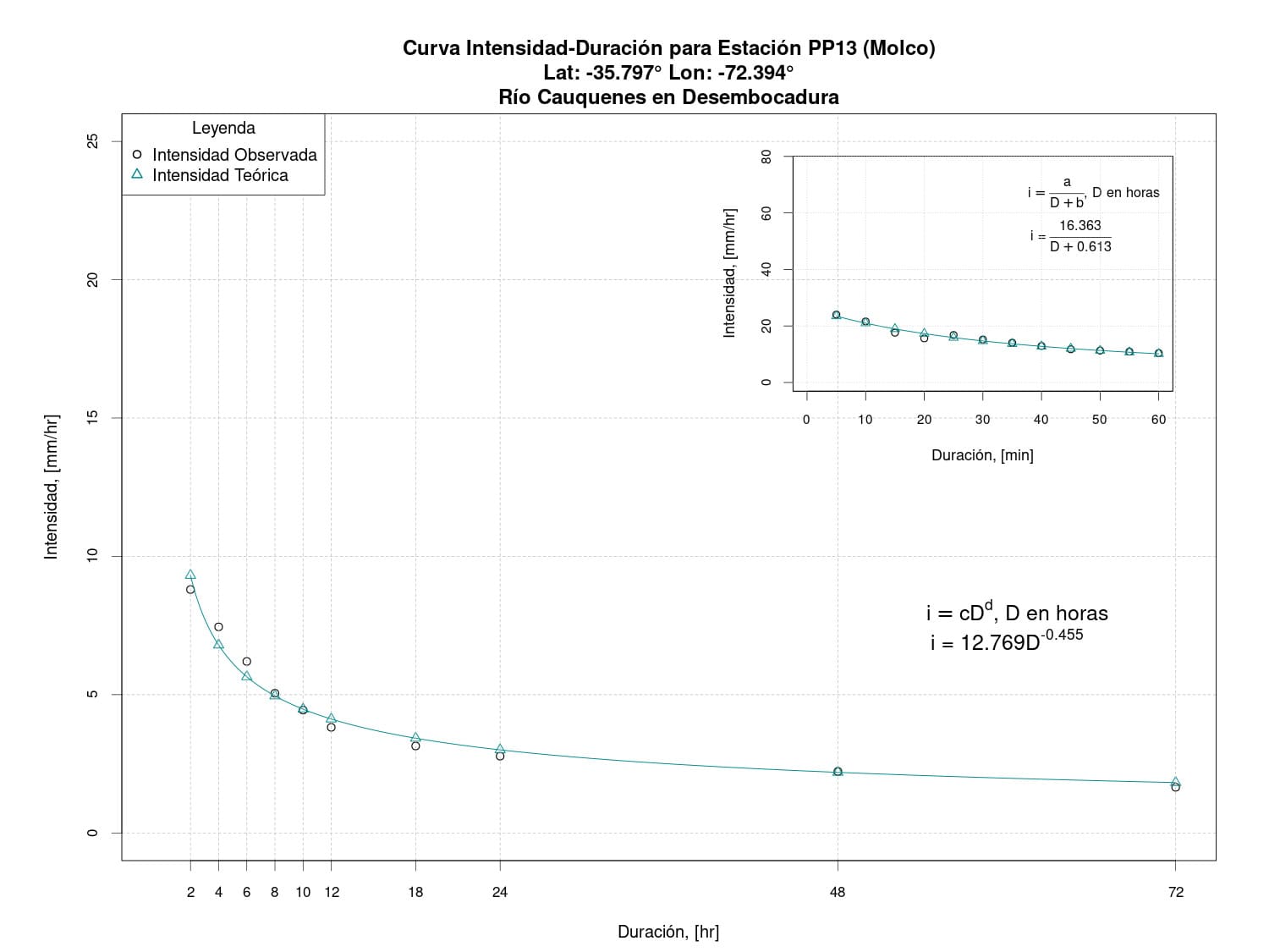
Figure 19. Intensity-Duration Curve for the Molco Station (PP13).
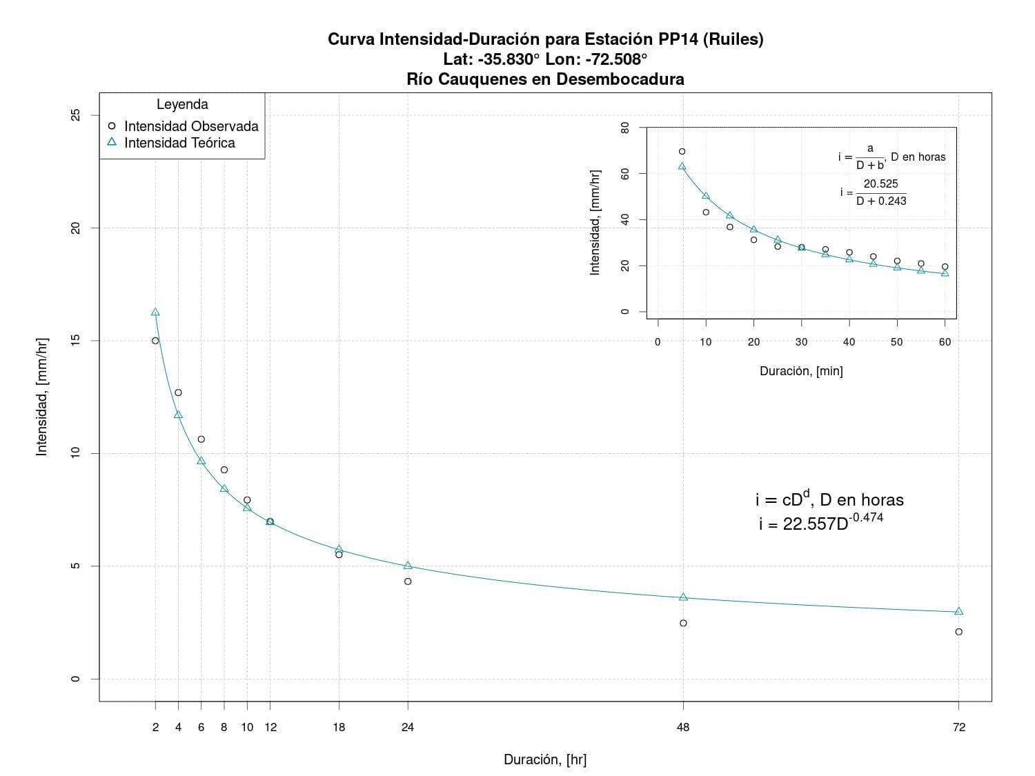
Figure 20. Intensity-Duration Curve for the Ruiles Station (PP14).
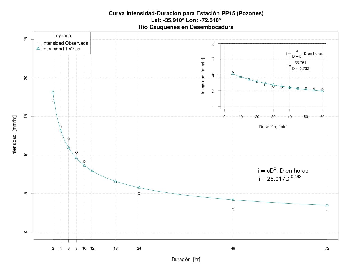
Figure 21. Intensity-Duration Curve for the Pozones Station (PP15).
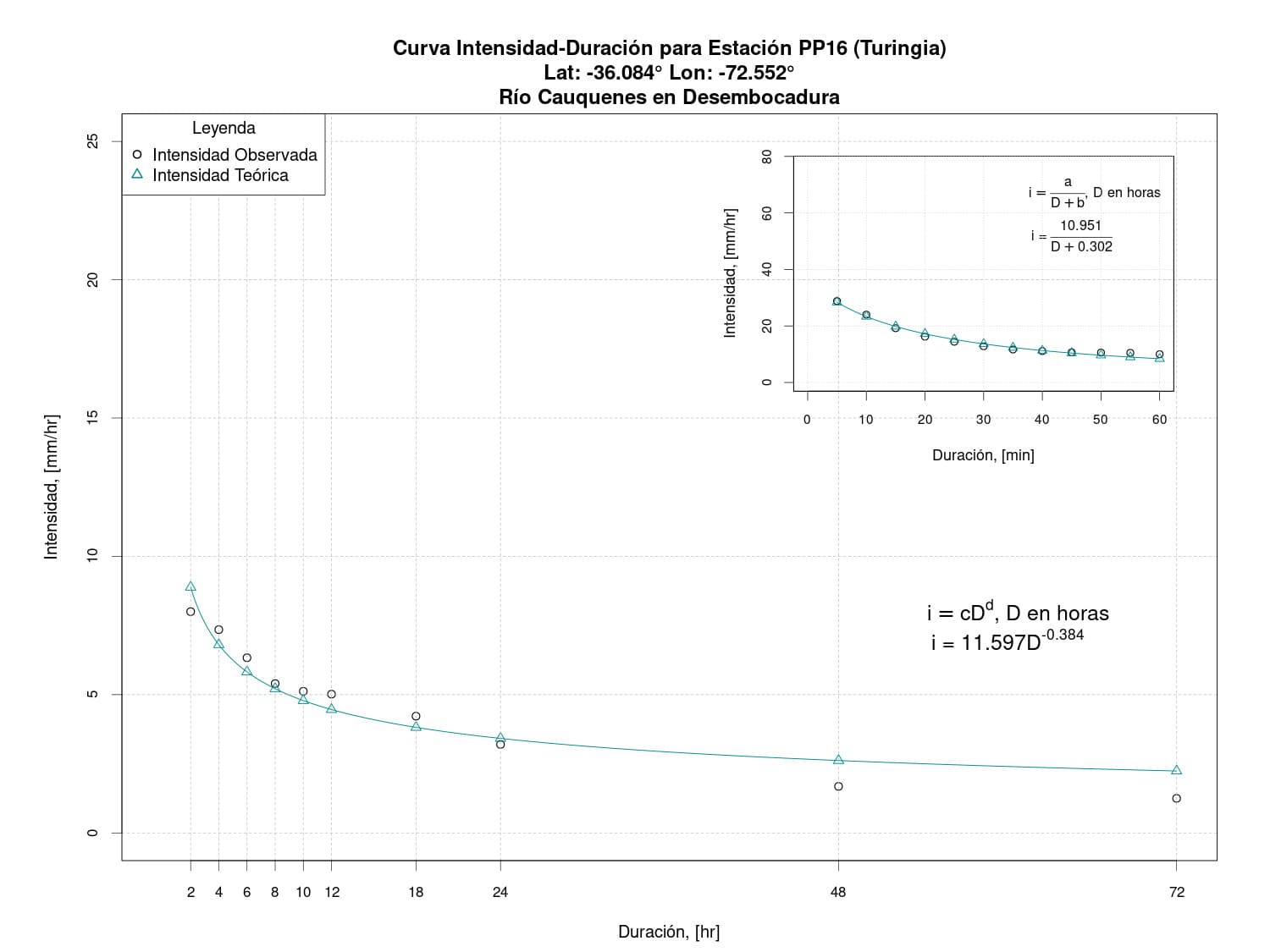
Figure 22. Intensity-Duration Curve for the Turingia Station (PP16).
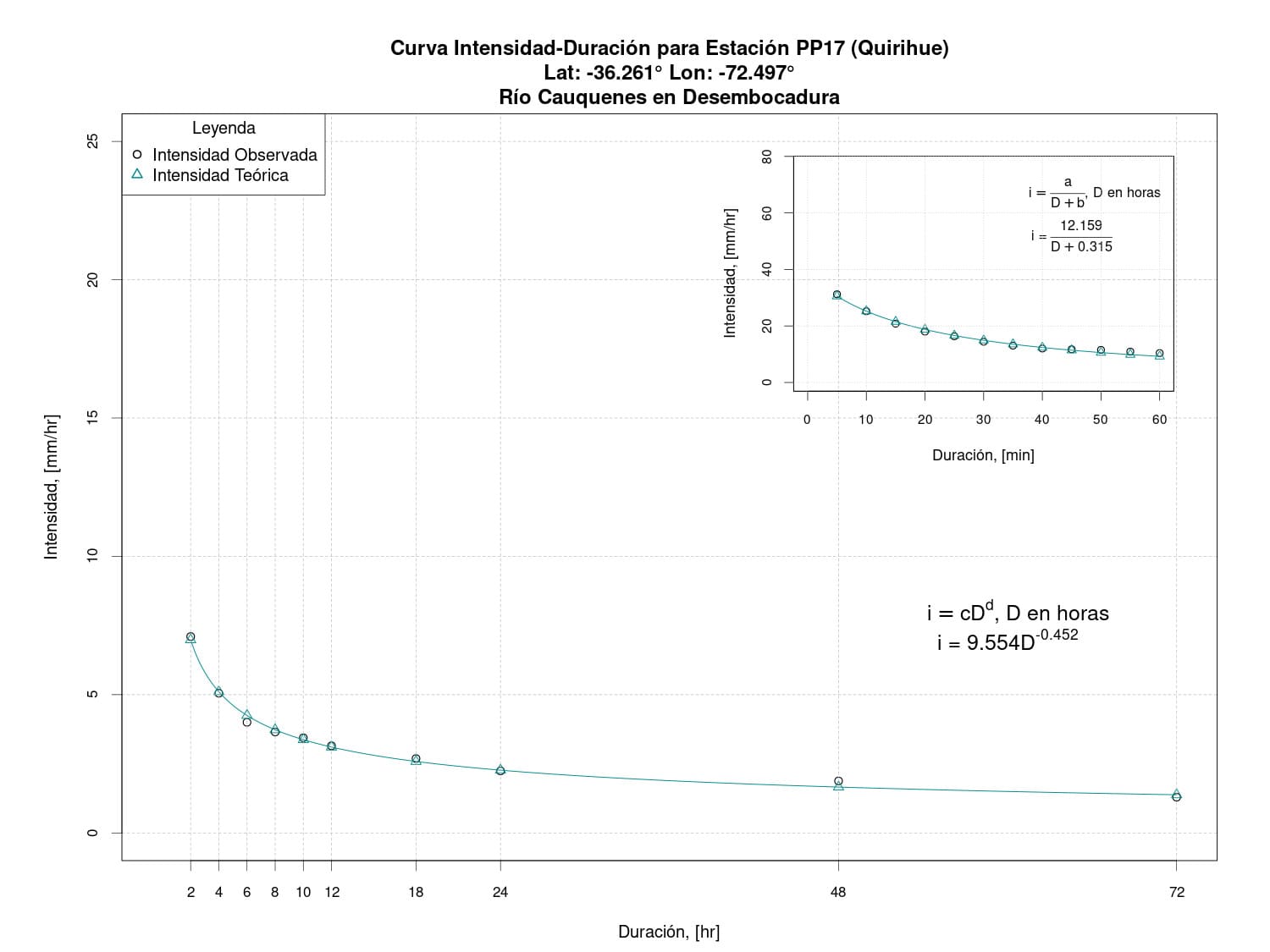
Figure 23. Intensity-Duration Curve for the Quirihue Station (PP17).
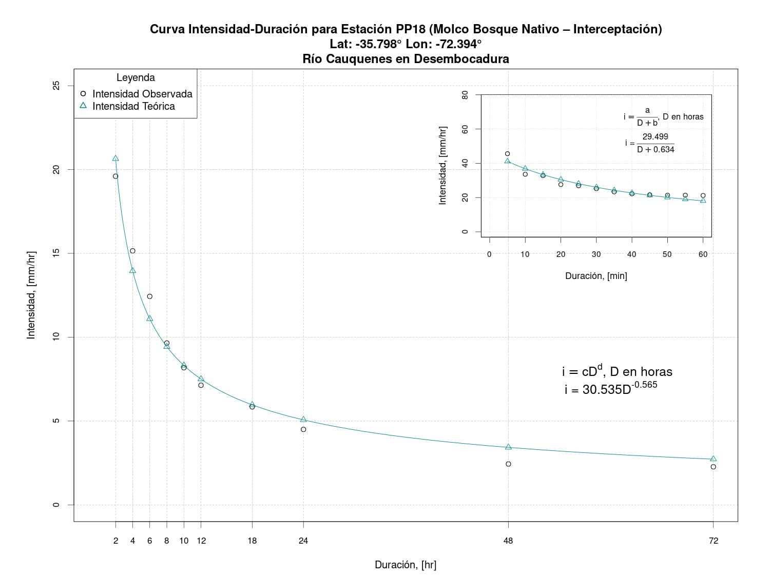
Figure 24. Intensity-Duration Curve for the Molco Native Forest – Interception Station (PP18).
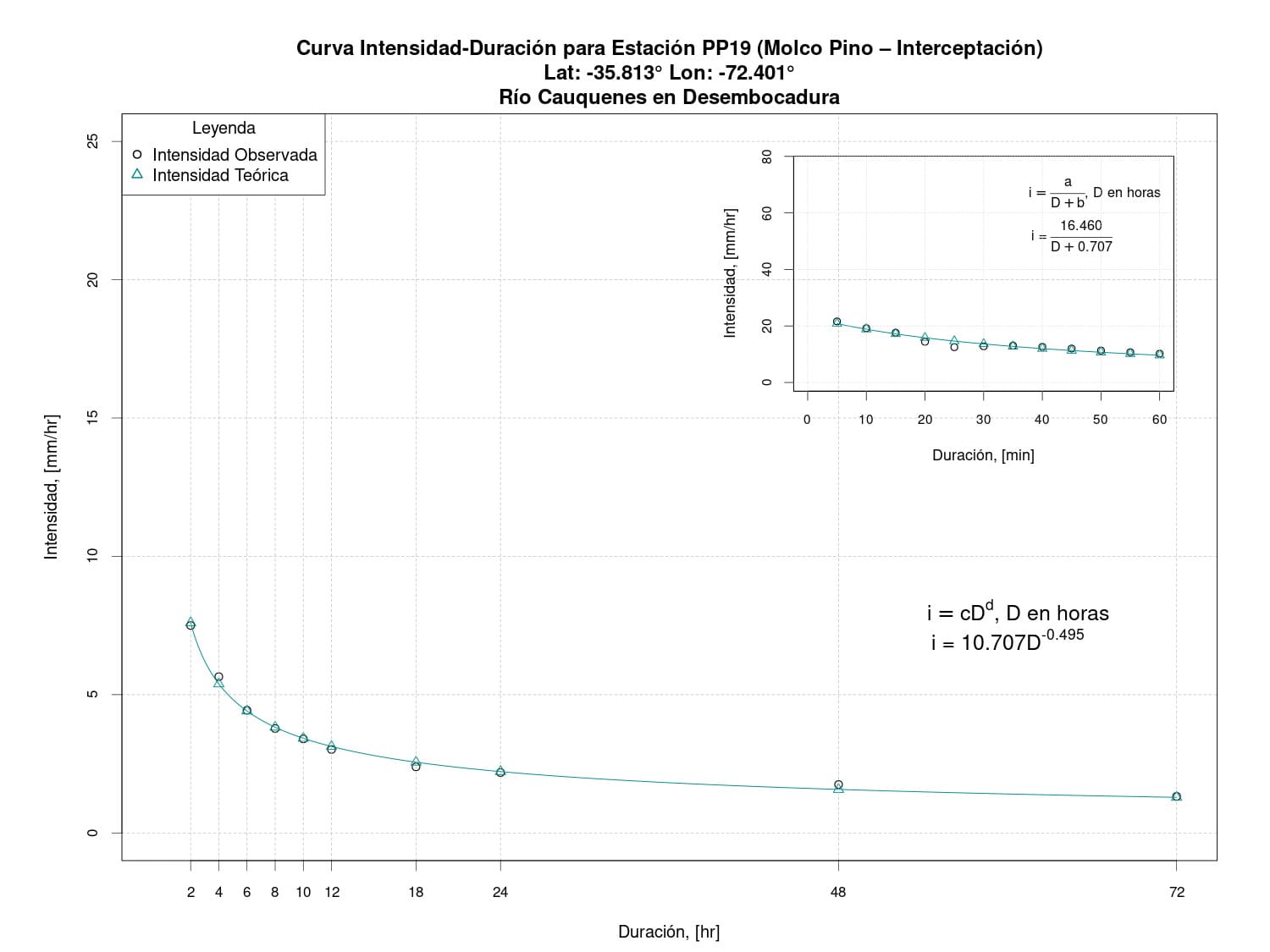
Figure 25. Intensity-Duration Curve for the Molco Pine – Interception Station (PP19).
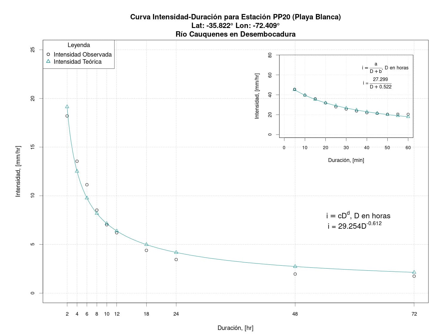
Figure 26. Intensity-Duration Curve for Playa Blanca Station (PP20).
Water Use Rights
According to the General Directorate of Water (DGA, 2023), responsible for granting Water Use Rights (DAA), a total of 131 DAA are recorded in its database for the Cauquenes River Sub-Sub-Basin up to the confluence with the Tutuven River, all of which correspond to consumptive rights.
Relevant references:
- Galleguillos, M.; Gimeno, F.; Puelma, C.; Zambrano-Bigiarini, M.; Lara, A.; Rojas, M. (2021) Disentangling the effect of future land use strategies and climate change on streamflow in a Mediterranean catchment dominated by tree plantations. Journal of Hydrology 595, 126047. doi:10.1016/j.jhydrol.2021.126047
- González, M.E.; Sapiains, R.; Gómez-González, S.; Garreaud, R.; Miranda, A.; Galleguillos, M.; Jacques, M.; Pauchard, A.; Hoyos, J.; Cordero, L.; Vásquez, F.; Lara, A.; Aldunce, P.; Delgado, V.; Arriagada Ugarte, A.M.; Sepúlveda, A.; Farías, L.; García, R.; Rondanelli, R.;J.; Ponce, R.;Vargas, F.; Rojas, M.; Boisier, J.P.; Carrasco, C.; Little, C.; Osses, M.; Zamorano, C.; Díaz-Hormazábal, I.; Ceballos, A.; Guerra, E.; Moncada, M.; Castillo, I .(2020). Incendios forestales en Chile: causas, impactos y resiliencia. Centro de Ciencia del Clima y la Resiliencia (CR)2. pp84. Santiago de Chile.
- Villalobos Parraguirre, A. A. (2020). Caracterización hidrológica de la cuenca Cauquenes (Chile) y evaluación del impacto del cambio climático utilizando Hydro-BID. Tesis para optar al grado de Master Universitario en Hidrologá y Gestión de Recursos Hídricos. Universidad de Alcalá-Universidad Rey Juan Carlos, España. Junio 2020.
- Beck, H. E., Zimmermann, N. E., McVicar, T. R., Vergopolan, N., Berg, A., & Wood, E. F. (2018). Present and future Köppen-Geiger climate classification maps at 1-km resolution. Scientific data, 5(1), 1-12. doi:10.1038/sdata.2018.214
- Ceballos-Comisso, A.; Galleguillos, M.; Gimeno, F.; Lara, A. (2021). A semi-automatic algorithm for historical Land Cover Mapping in a complex dynamic landscape of central Chile. Technical report.
- Galleguillos, M., Ceballos-Comisso, A., Gimeno, F., & Zambrano-Bigiarini, M. (2024). CLDynamicLandCover [Data set]. Zenodo. https://doi.org/10.5281/zenodo.13153631
- Luebert, F.; Pliscoff, P. (2018). Sinopsis bioclimática y vegetacional de Chile. Editorial Universitaria. pp384. ISBN/ISSN:9789561125759. Santiago de Chile.
- Alaniz, A. J.; Galleguillos, M.; Perez-Quezada, J. F. (2016). Assessment of quality of input data used to classify ecosystems according to the IUCN Red List methodology: The case of the central Chile hotspot Biological Conservation, 204, 378-385. doi.org/10.1016/j.biocon.2016.10.038
- Zhao, Y.; Feng, D.; Yu, L.; Wang, X.; Chen, Y.; Bai, Y.; Hernández, H.J.; Galleguillos, M.; Estades, C.; Biging, G.S.; Radke, J.D.; Peng, G. (2016). Detailed dynamic land cover mapping of Chile: Accuracy improvement by integrating multi-temporal data. Remote Sensing of Environment, 183, 170-185. doi:10.1016/j.rse.2016.05.016.
- Soto, N. (2015). La construcción del paisaje del vino en el Valle Central de Chile: Cauquenes, 1700-1850.. Revista Iberoamericana de Viticultura, Agroindustria y Ruralidad, 2(4), 71-87.
- DGA (2013). Modelación hidrogeológica de la Cuenca del Río Cauquenes. Informe Final. Realizado por GCF Ingenieros. S.I.T. 321. Santiago, noviembre 2013.
- MINVU (Ministerio de Vivienda y Urbanismo). (2012). Plan Regulador Intercomunal de Cauquenes, Chanco y Pelluhue Región del Maule. pp64. Maule, Chile.
- Luzio, W.; Casanova, M.; Seguel, O. (2010). Suelos de Chile. Editorial MAVAL. pp364. ISBN:9789561906488. Santiago de Chile.
- Arnold, F.; Sepúlveda, C.; San Martín, J.; Boshier, D.; Penailillo, P.; Lander, T.; Garrido, P.; Harris, S.; Hawthorne, W. (2009) Propuesta de una estrategia de conservación para bosques nativos de la sub-región costera del Maule Proyecto Darwin Maule. pp97. doi:10.13140/2.1.4928.4802. Talca, Chile.
- Little, C.; Lara, A.; McPhee, J.; Urrutia, R. (2009). Revealing the impact of forest exotic plantations on water yield in large scale watersheds in South-Central Chile. Journal of Hydrology, 374, 162-170. doi.org/10.1016/j.jhydrol.2009.06.011
- CONAMA. (2008) [Biodiversidad de Chile: Patrimonios y desafíos] (https://biblioteca.uss.cl/wp-content/uploads/2016/09/Biodiversidad-de-Chile.-Patrimonio-y-desafíos-CONAMA.pdf). Ocho Libros Editores LTDA. pp320. ISBN: 978-956-8018-56-6. Santiago de Chile.
- Bustamante, R.; Simoneti, J.; Grez, A.; San Martín, J. (2005). Fragmentación y Dinámica de Regeneración del Bosque Maulino: Diagnostico Actual y Perspectivas Futuras. Smith-Ramírez, C; Armesto, J.; Valdovinos, C (Eds.) Historia, biodiversidad y ecología de los bosques costeros de Chile Editorial Universitaria. pp555-564. ISBN:9561117770. Santiago de Chile.
- Martínez, R.(2004). Mapa de reconocimiento de suelos de la VIII Región del Bío-Bío (sector sur). Memoria para optar al Título Profesional de Ingeniero Agrónomo Mención Manejo de Suelos y Aguas. Universidad de Chile. Santiago de Chile.
- SERNAGEOMIN (Servicio Nacional de Geología y Minería). (2003). Mapa Geológico de Chile: versión digital. Geológica Digital N°4. Santiago, Chile. Esc. 1:1.000.000.Publicación Geológica Digital, 4.
- Bravo, P. (2001). Geología del borde oriental de la Cordillera de la Costa entre los ríos Mataquito y Maule, VII Región. Memoria de Título para optar al grado de Licenciado en Ciencias con mención en Geología . Universidad de Chile. Santiago de Chile.
- Fierro, P.; Pancel, L.; Rivera,H.; Castillo, J.C.(1998).Experiencia silvicultural del bosque nativo de Chile: recopilación de antecedentes para 57 especies arbóreas y evaluación de prácticas silviculturalesPublicaciones Lo Castillo S.A. pp420. ISBN:9567669023. Santiago de Chile.
- CIREN. (1997). Estudio agrológico VII Región: Descripciones de suelos. Publicación CIREN N°117.
- Armesto, J.J.; Pickett, S. T. (1985). A mechanistic approach to the study of succession in the Chilean matorral. Revista Chilena de Historia Natural58, 9-17.
Related videos:
- Municipalidad de Cauquenes (2022). “Crisis Hídrica en el Secano”. Video sobre el seminario “Crisis Hídrica en el Secano” realizado por la Unidad de medio Ambiente de la Municipalidad de Cauquenes junto a la Asociación Gremial Vinos Cauquenes. Mayo 19, 2022.
- 24 HORAS TVN (2022). Río Cauquenes es el más contaminado de Chile Tercer Muestreo Nacional de Basura mostró que tiene 1,6 desechos por metro cuadrado. Febrero 10, 2022.
- Resumen TV (2022). Reconstrucción avance del megaincendio Las Máquinas en 2017. Reconstrucción de la superficie afectada por el megaincendio ocurrido hace 5 años en la Región del Maule. Febrero 2, 2022.
- Viejo Espino (2021). Provincia de Cauquenes en 360° Tour fotográfico. Tour fotográfico por los cuatro puntos cardinales de la Provincia de Cauquenes. 2021.
- Municipalidad de Cauquenes (2021). Enoturismo en la “Fiesta del Vino País” Cauquenes. Noviembre 4, 2021.
- 24 HORAS TVN (2021). Vecinos de Cauquenes denuncian extracción indiscriminada de agua. Marzo 19, 2021.
- Alejandro Tumayan (2020). Territorium - video/docu. Video documental y testimonial con imágenes grabadas en el Maule Sur, Chile, específicamente en las localidades de Curanipe, Cauquenes, Pelluhue, Chanco, Coronel de Maule, Molco y Name. Noviembre 17, 2020.
- Sernatur (2018). CAUQUENES - Region del Maule. Video que resume diferentes lugares turísticos de Cauquenes y sus alrededores. 2018.
Related news:
- Todovinos (2022). Secano y crisis hídrica, testimonios de lo que ocurre. Junio 13, 2022.
- Atentos (2022). Seminario realizado en Cauquenes se centró en el uso del agua y la crisis hídrica. Mayo 20, 2020.
- El Mercurio (2022). Alerta roja en Cauquenes por incendios forestales: Hay más de 1.300 hectáreas consumidas. Febrero 10, 2022.
- El Mostrador (2022). El inminente ocaso de los bosques maulinos. Febrero 5, 2022.
- Resumen (2022). A 5 años del incendio más grande de la historia: las peligrosas plantaciones forestales siguen dominando la Cordillera de la Costa del Maule. Febrero 4, 2022.
- El Desconcierto (2021). Reforestar con especies nativas: la propuesta para mitigar la falta de agua en las cuencas por sequía. Septiembre 3, 2021.
- La Tercera (2021). Esta es la última víctima del cambio climático en Chile. Marzo 16, 2021.
- U. Chile (2021). ¿Por qué se secó la cuenca del río Cauquenes? Investigadores de la U. de Chile estudiaron las razones. Marzo 30, 2021.
- Cauquenino (2021). En la cuenca del Río Cauquenes los efectos del cambio de uso de suelo y del cambio climático; una pérdida que de acuerdo a los expertos sería irreparable. Marzo 31, 2021.
- País Circular (2020). Expansión urbana y forestal causan pérdida de bosque nativo en las cuencas de los ríos Maipo y Maule, claves para su seguridad hídrica. Septiembre 22, 2020.
- Diario Futrono (2020). Descubren pérdida de bosque nativo en cuencas del Maipo y Maule. Septiembre 13, 2020.
- Publimetro (2020). La catástrofe en imágenes: los paisajes de Chile que evidencian las cicatrices de la megasequía y el cambio climático. Febrero 24, 2020.
- Resumen (2019). Plantaciones forestales de pino y eucalipto afectan suministro de agua en grandes cuencas, indica estudio. Septiembre 22, 2019.
- (CR)2. (2019). El impacto del bosque nativo y las plantaciones forestales en el suministro de agua en Chile. Septiembre 6, 2019.
- Decoop Chile (2016). CAUQUENES Y SU HISTORIA VITIVINICOLA. Abril 13, 2016.