Mapocho River in Almendros
Description
The Mapocho River Basin in Los Almendros is part of the upper zone of the Maipo River Basin, one of the most important in central Chile and the one that supplies the capital city, Santiago. The Mapocho River Basin in Los Almendros has a total area of 637 km², extending between 33°05’-33°30’ south latitude and 70°10’-70°28’ west longitude, located in the mountainous region of central Chile, northeast of Santiago in the Metropolitan Region. Elevations in the basin reach up to 5431 meters above sea level at its highest point, while the gauging station that defines it is located at 966 meters above sea level.
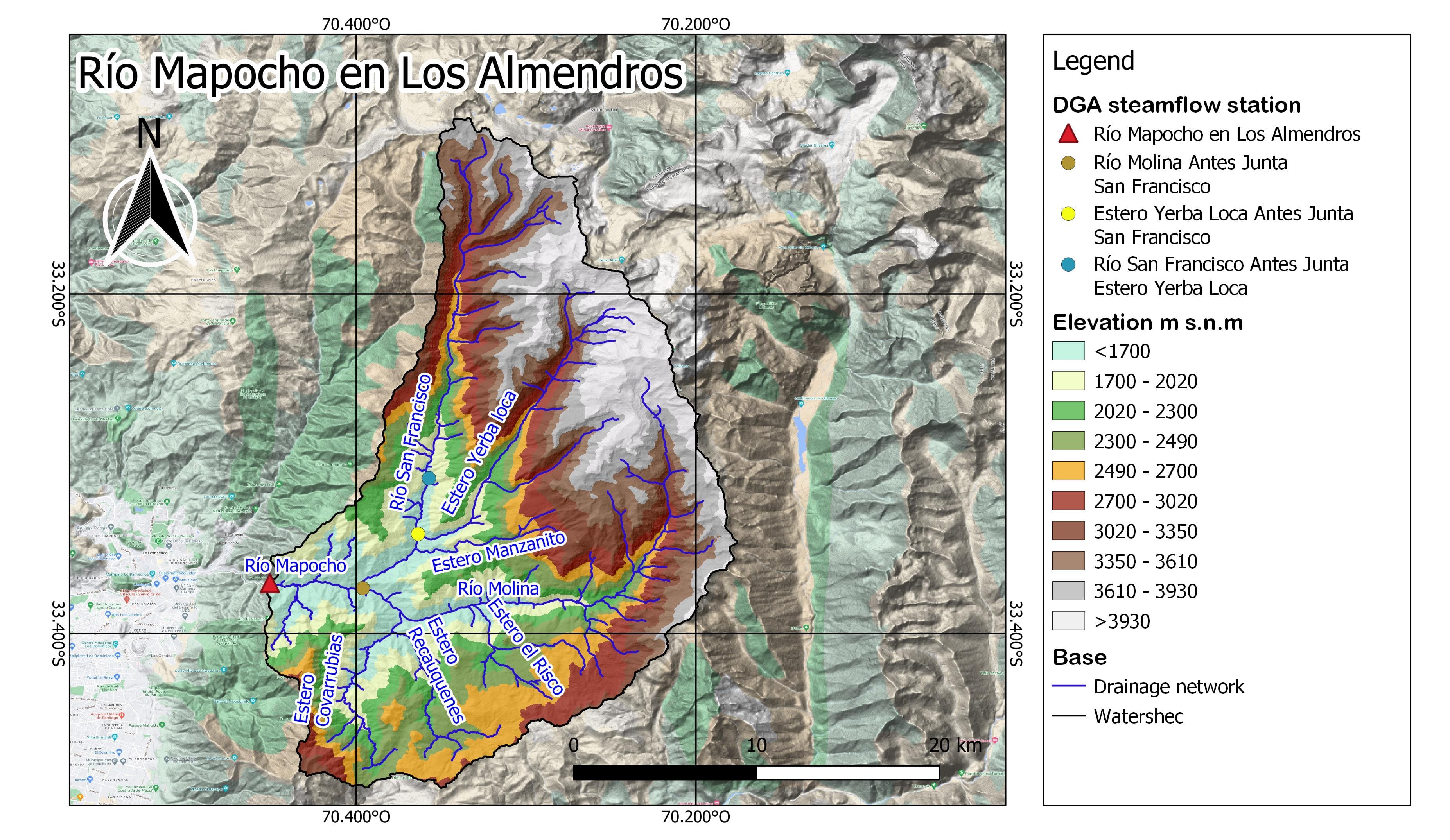
Figure 1. Elevation map of the Mapocho River Basin in Los Almendros.
The main sub-basins of the Mapocho River are the Molina River Before the San Francisco Junction, the San Francisco River Before the Yerba Loca Creek Junction, and the Yerba Loca Creek Before the San Francisco Junction, which can be seen in Figures 2, 3, and 4, respectively.
Regarding the Molina River Before the San Francisco Junction, this sub-basin has an area of 224 km², with elevations ranging from 1204 to 5293 meters above sea level.
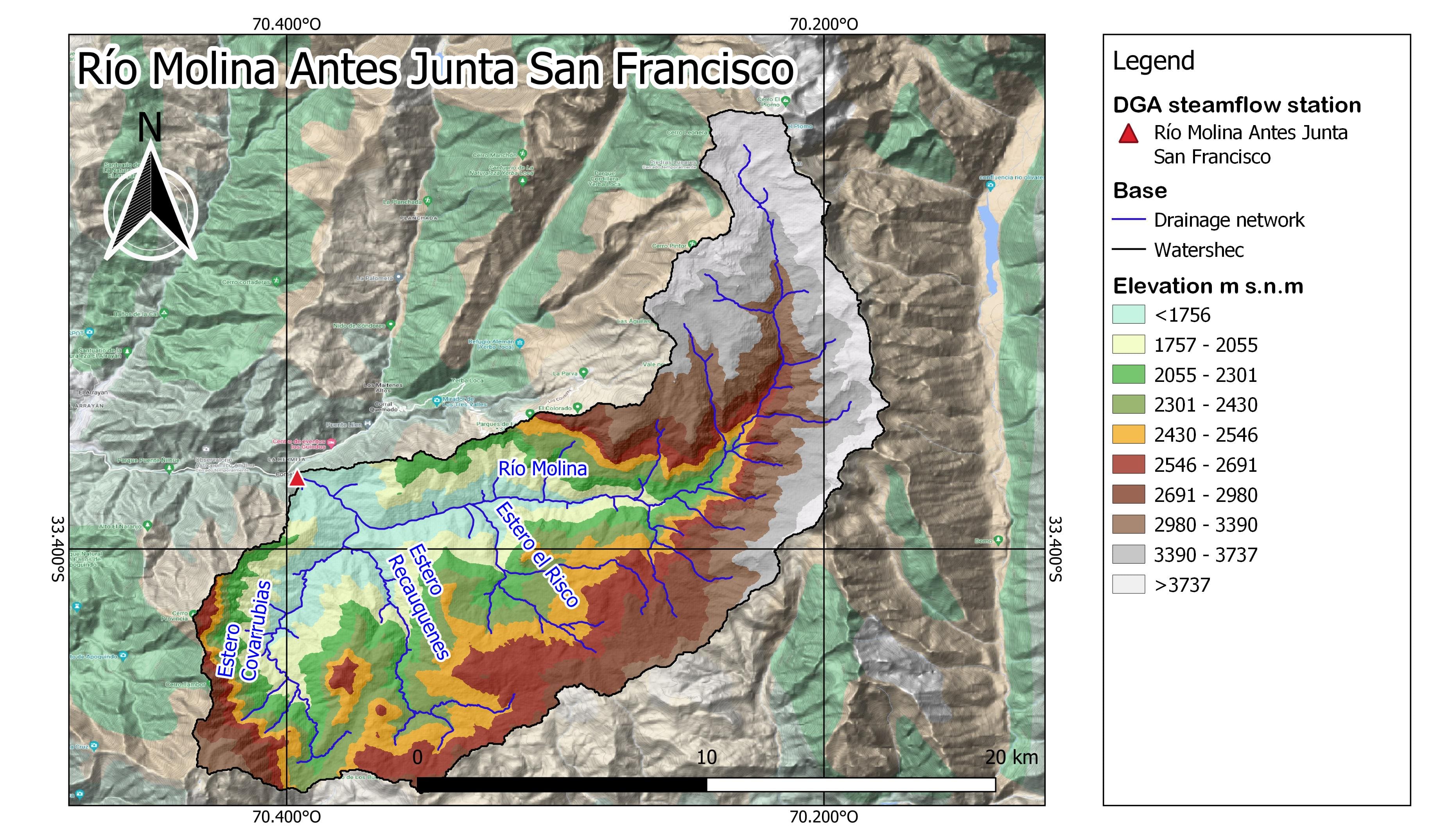
Figure 2. Elevation map of the Molina River Sub-basin Before the San Francisco Junction.
On the other hand, the San Francisco River Sub-basin Before the Yerba Loca Creek Junction covers an area of 184 km², with elevations between 1551 and 4527 meters above sea level.
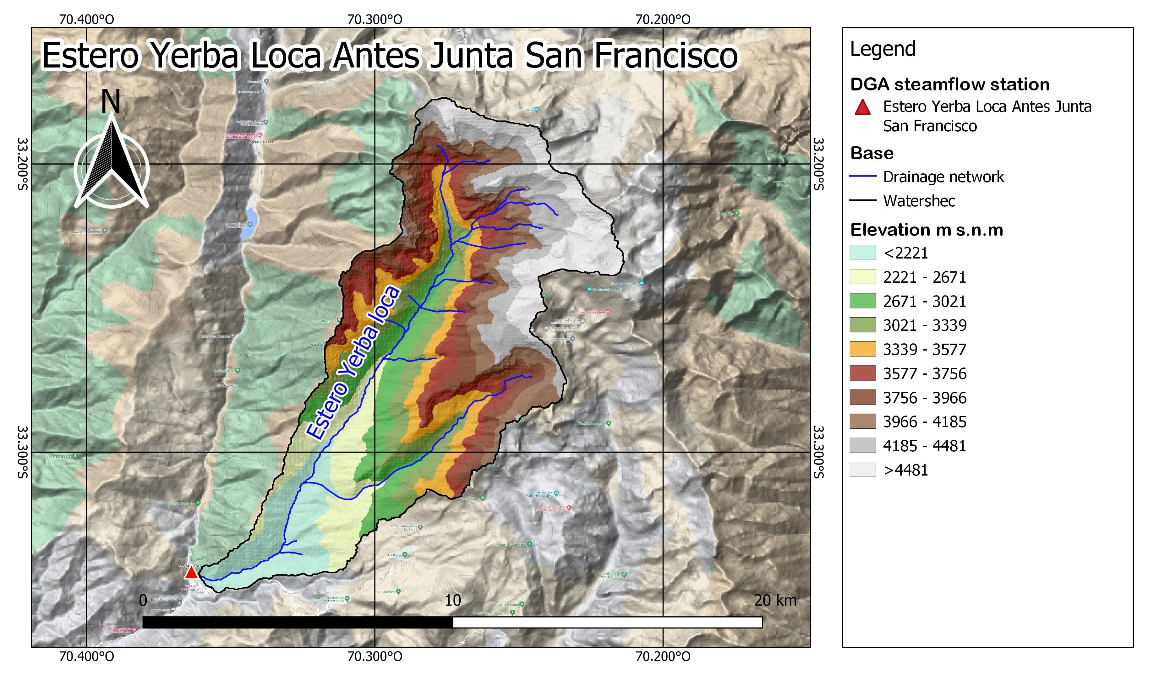
Figure 3. Elevation map of the San Francisco River Sub-basin Before the Yerba Loca Creek Junction.
Finally, the Yerba Loca Creek Sub-basin Before the San Francisco Junction has an area of 254 km², with elevations ranging from 1382 to 5404 meters above sea level.
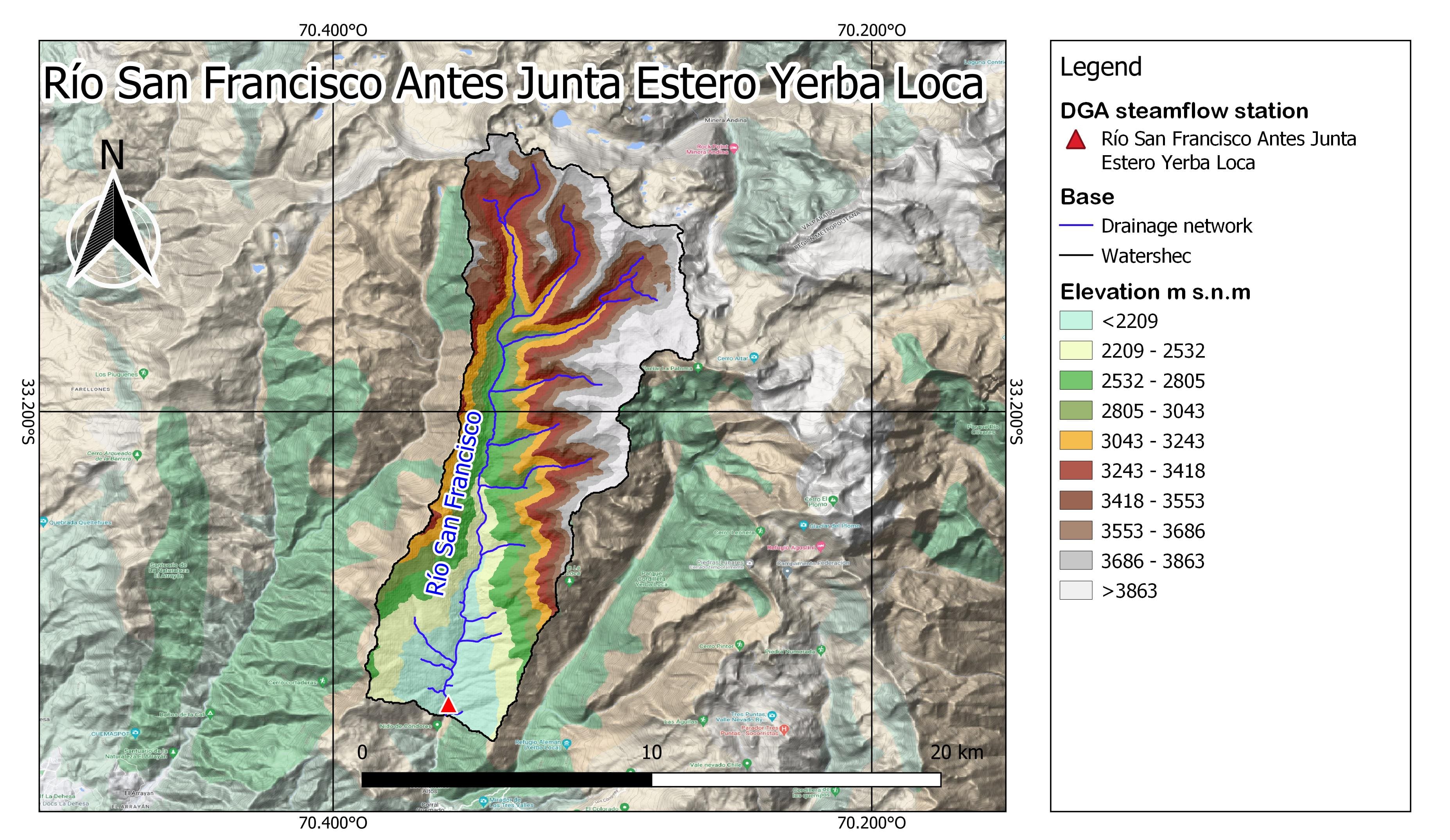
Figure 4. Elevation map of the Yerba Loca Creek Sub-basin Before the San Francisco Junction.
Both the main basin of the Mapocho River in Los Almendros and the three sub-basins that compose it present a nival-pluvial regime, which combines the influence of snow accumulation and rainfall throughout the year. As a result, the basin exhibits a distinctive flow pattern that varies seasonally. During the spring months, especially in September, October, and November, there is a significant increase in river and stream flows in the basin. This increase is due to the melting of snow accumulated in the mountainous regions during winter. Snowmelt provides a substantial amount of water to watercourses, resulting in higher flows.
In contrast, the winter season, covering June, July, and August, is characterized by increased rainfall. Despite the abundant rains during this period, flows in the basin are relatively lower compared to the spring. This is because the primary contribution comes from the snowmelt process accumulated in the mountains. As summer approaches, precipitation tends to decrease, and the basin experiences a gradual reduction in rainfall. Nevertheless, flows continue to rise due to the ongoing snowmelt, which contributes to the steady flow of water in the basin’s rivers and streams.
Hydrology
The Mapocho River basin encompasses several main channels, with the San Francisco River, the Yerba Loca Creek, and the Molina River being the most prominent. These rivers are tributaries of the Mapocho River, and their main use is irrigation for both agricultural crops and forestry plantations as well as natural meadows (CADE-IDEPE, 2004).
The basin is divided into five sub-basins: Yerba Loca Creek before the San Francisco River junction, Molina River before the San Francisco River junction, San Francisco River before the Yerba Loca Creek junction, Mapocho River between the San Francisco River confluence and Los Almendros, and San Francisco River before the Yerba Loca Creek junction.
The Yerba Loca Creek sub-basin has a total area of 119 km², of which 8.1% corresponds to glaciers. This sub-basin has been designated as a protected area under the category of Nature Sanctuary and ecological preservation.
On the other hand, the Molina River basin covers an area of 300 km², with 4% of its area occupied by glaciers. Much of this basin is used for livestock activity.
Lastly, the San Francisco River sub-basin has an area of 108 km², making it the smallest of those mentioned above, with 4.4% rocky glacier coverage (Anglo American, 2021).
Climate
According to the Köppen-Geiger classification, five climate types are observed in the basin (Beck et al., 2018). The lower part (up to 2480 meters above sea level) is characterized by a prolonged temperate dry summer. As elevation increases, a drier and colder climate appears, with low temperatures favoring snow accumulation.
For a future climate classification (2071-2100), Figure 5 shows how the prolonged temperate dry summer extends to elevations up to 3464 meters above sea level, causing a reduction in the area that previously experienced a drier and colder climate. This negatively impacts snow accumulation in the upper zone, as accumulation would tend to decrease.
In the context of the Mapocho River Basin in Los Almendros, the following climate types have been identified for the current and future periods:
- Bsk: Cold steppe climate. This type is characterized by cold, dry winters and warm summers. Precipitation is generally scarce, and the vegetation is adapted to drought conditions.
- Csb: Temperate climate with dry, warm summers. Similar to Csa, but with slightly milder summer temperatures. Rainy seasons occur in winter, with more evident droughts in summer. Common in coastal regions with maritime influence.
- Csc: Temperate climate with dry, cool summers. Summers are dry and cool rather than warm, with moderate temperatures and more abundant winter precipitation. Typical of areas with less oceanic influence.
- Dsc: Cold climate with dry, cool summers. Similar to Dsb but with cooler summers. Precipitation is low year-round, with short, cool summers. Found in cold areas with maritime influence.
- EF: Polar ice cap climate, characterized by extremely low temperatures year-round, with very scarce precipitation and permanent ice coverage.
- ET: Polar tundra climate, with very short, cold summers and low-growing tundra vegetation adapted to the cold.
These climate categories are essential for understanding the region’s climate characteristics, both in the present and in future projections. Analyzing climate trends is crucial for decision-making regarding planning and adaptation to potential climate changes.
Figure 5. Köppen-Geiger climate classification map of the Río Mapocho Basin in Los Almendros for the present period (1980–2016) and the future (2071-2100). Source: Beck et al., 2018.
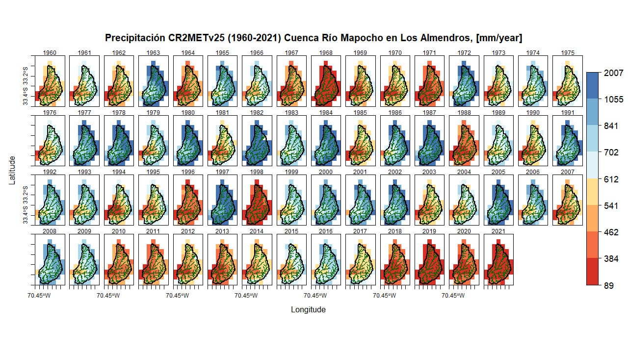
Figure 6. Annual precipitation (1960-2021) Río Mapocho Basin in Los Almendros.
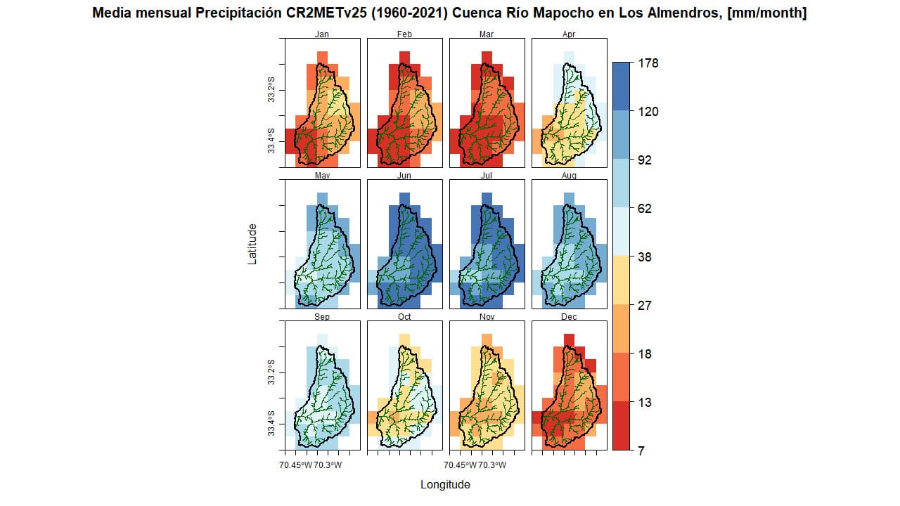
Figure 7. Average monthly precipitation (1960-2021) Río Mapocho Basin in Los Almendros.
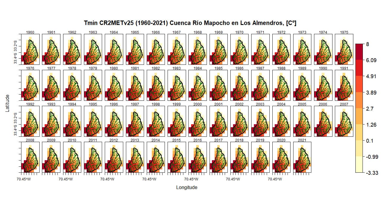
Figure 8. Annual minimum temperature (1960-2021) Río Mapocho Basin in Los Almendros.
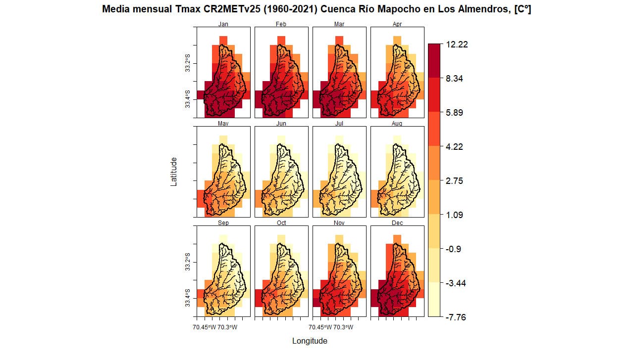
Figure 9. Average monthly minimum temperature (1960-2021) Río Mapocho Basin in Los Almendros.
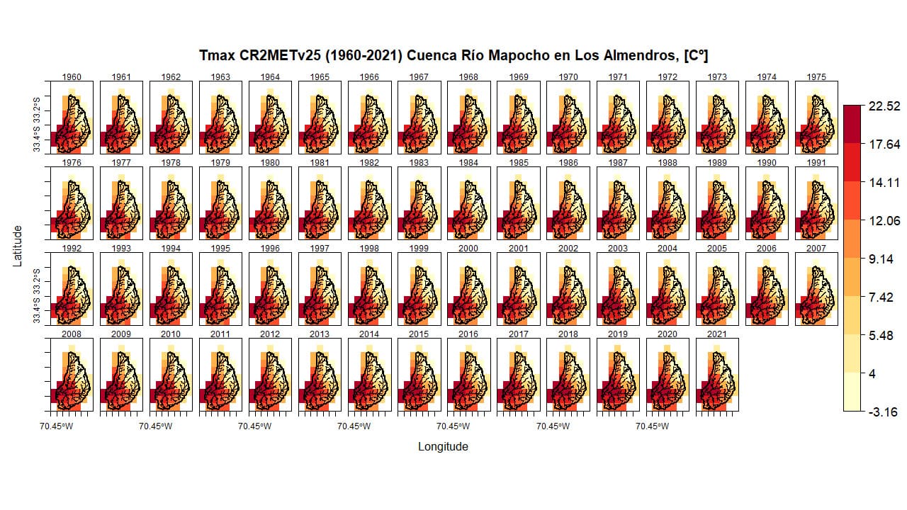
Figure 10. Annual maximum temperature (1960-2021) Río Mapocho Basin in Los Almendros.
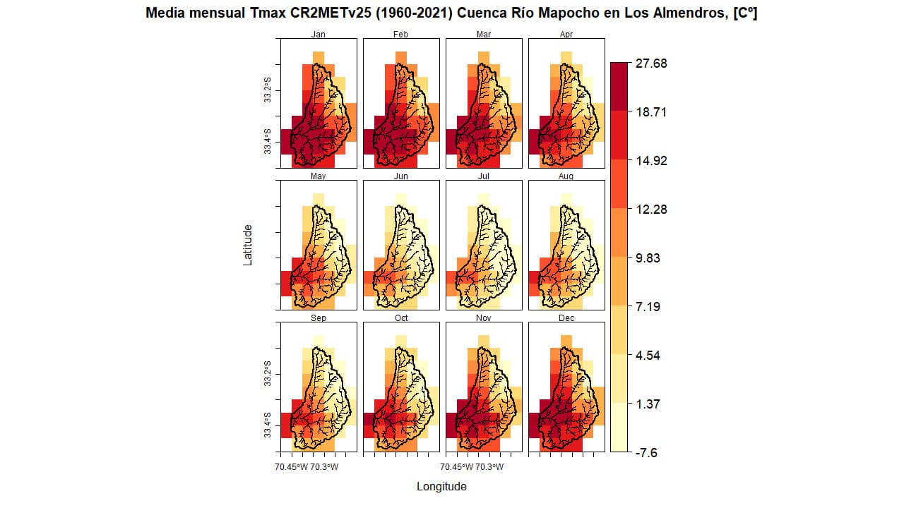
Figure 11. Average monthly maximum temperature (1960-2021) Río Mapocho Basin in Los Almendros.
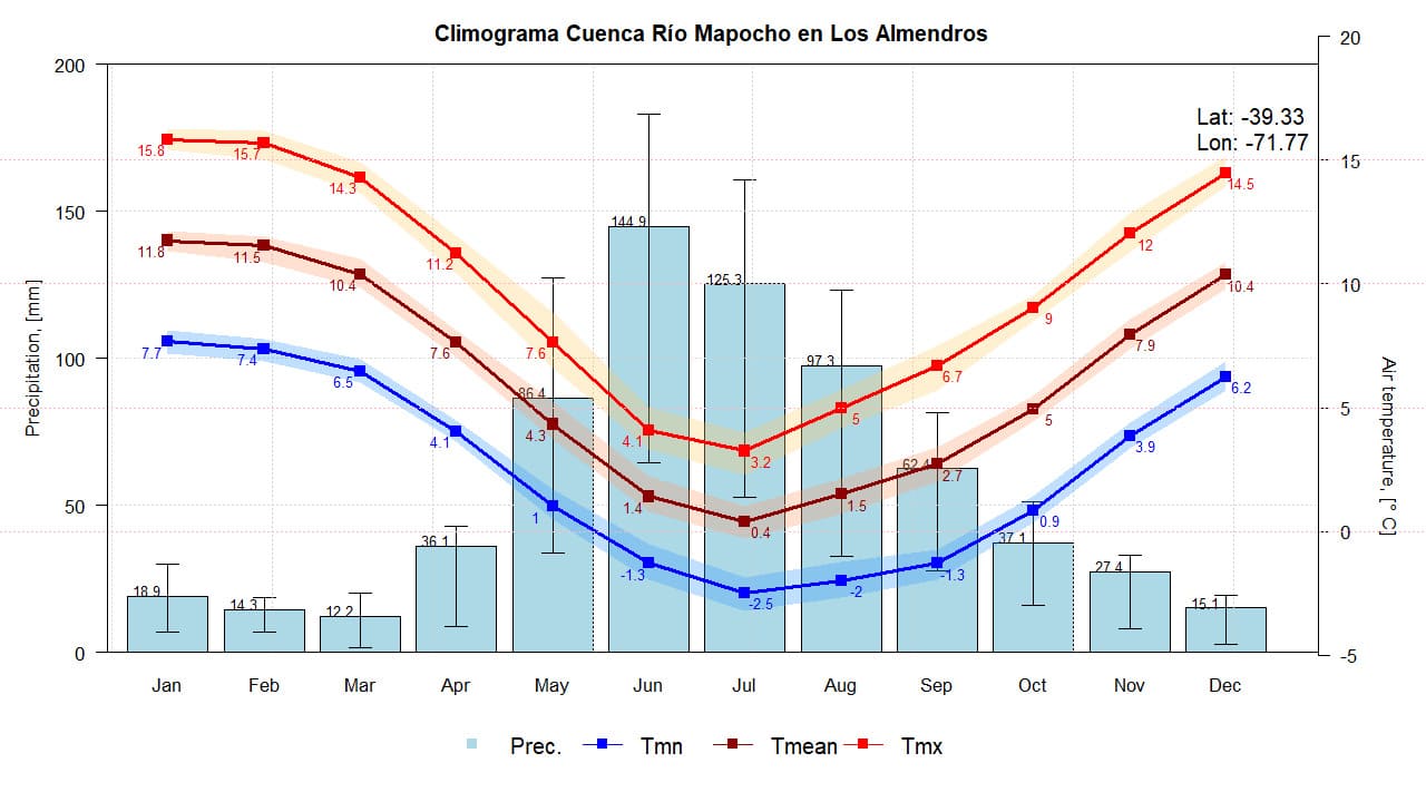
Figure 12. Climograph of the Río Mapocho Basin in Los Almendros. Prepared using CR2METv2.5 data.
Land Use
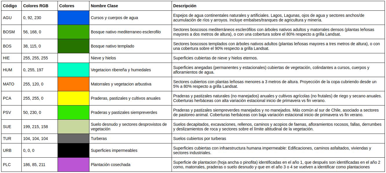
In the lower part of the basin (up to 2480 m.a.s.l.), there is a significant presence of shrubs and bush-type vegetation, and above 2500 m.a.s.l., the high Andean desert areas begin, with sparse or no vegetation. The following figure shows how these land uses vary over time.
Figure 13. Land use map of the Río Mapocho Basin in Los Almendros. Source: Ceballos et al. (2021) y Galleguillos et al. (2024).
Table 1. Descriptive table of land cover in the Río Mapocho Basin in Los Almendros.
Soil Type
In the lower part, volcano-sedimentary sequences are distinguished, with epiclastic and pyroclastic rocks, and basaltic to dacitic lavas. The higher part presents a skeletal soil over rock outcrops, with partially eroded volcanic complexes and volcanic sequences, including lavas, breccias, domes, and pyroclastic rocks ranging from andesitic-basaltic to dacitic compositions. Due to erosion on the slopes with steep gradients, surface material is carried toward the riverbeds (Sernageomin, 2003).
Additionally, in the high valleys, morainic forms exist (Araya-Vergara, 1985), which during the Quaternary were associated with glacial cirques, while today they are associated with the snow and periglacial domains. Thus, the slopes have good capacity for generating debris through frost weathering, classifying these areas as avalanche zones (Castro et al., 2004).
Geology
In the upper elevations of the mountain range, the area is characterized by skeletal soil found over rock outcrops. The underlying geology in the basin allows for limited surface infiltration and poor groundwater accumulation and transmission. Erosion on steep slopes leads to the redistribution of material into the riverbeds (CADE-IDEPE, 2004).
In the lower regions of the basin, volcano-sedimentary sequences can be distinguished, including basaltic to dacitic lavas, as well as epiclastic and pyroclastic rocks. In the higher areas, volcanic complexes have undergone partial erosion. Additionally, volcanic sequences are observed, consisting of lavas, breccias, domes, and pyroclastic rocks, with compositions ranging from andesitic-basaltic to dacitic (SERNAGEOMIN, 2003).
The vegetation found in the basin is typical of high mountain environments, where altitude and rugged, mountainous terrain play a decisive role in the composition of plant communities. In the lower areas of the basin, sub-Andean and Andean shrublands extend up to approximately 2000 meters above sea level. Above this altitude, the characteristic vegetation of the high Andean steppe prevails, which is marked by the presence of short-stature plants. In the highest parts of the basin, located above 3000 meters, the high Andean desert is found, where vegetation is scarce or virtually non-existent (Muñoz et al., 2000).
Relevant references:
- Anglo American. (2021). Ecosistemas de montaña de la cuenca alta del río Mapocho (1.a ed). Centro de Ecología Aplicada y Sustentabilidad de la Pontificia Universidad Católica de Chile.
- Araya Vergara, J. F. (1985). Análisis de la carta geomorfológica de la cuenca del Mapocho. Investigaciones Geográficas. Investigaciones Geográficas, (32), 31-44.
- CADE-IDEPE (2004). Diagnóstico y clasificación de los cuerpos de agua según objetivos de calidad: Cuenca del Río Maipo. Gobierno de Chile. Ministerio de Obras Públicas. Dirección General de Aguas. julio, 2004.
- Castro, C. P., Soto, M. V., & Chávez, C. (2004). Caracterización geomorfológica del corredor de comercio Las Leñas, valle del Río Cachapoal, Andes de Chile central. Revista de Geografía Norte Grande, (31), 85-98.
- Ceballos-Comisso, A.; Galleguillos, M.; Gimeno, F.; Lara, A. (2021). A semi-automatic algorithm for historical Land Cover Mapping in a complex dynamic landscape of central Chile. Technical report.
- Galleguillos, M., Ceballos-Comisso, A., Gimeno, F., & Zambrano-Bigiarini, M. (2024). CLDynamicLandCover [Data set]. Zenodo. https://doi.org/10.5281/zenodo.13153631
- Muñoz Schick, M., Moreira-Muñoz, A., & Villagrán, C. (2000). Caracterización florística y pisos de vegetación en Los Andes de Santiago, Chile Central.
- Pauta (2022). Paso a paso: cómo funcionaría el plan de racionamiento de agua en Santiago. abril 12, 2022.
- Pérez, W., Pardo-Pascual, J., Briceño, I., & Vidal, P. (2019). Study of natural hazards in the upper part of the Mapocho river basin, Metropolitan Region of Chile, using satellite imagery.
- Sernageomin (2003). Mapa Geológico de Chile: versión digital. Gobierno de Chile. Servicio Nacional de Geología y Minería, Publicación Geológica Digital, No. 4 (CD-ROM, versión1.0, 2003). Santiago.
Related videos:
- 24horas TVN. (2023, 29 de junio). Así es el “sucio negocio” de la basura clandestina.
- 24horas TVN. (2023, 24 de junio). Mapocho: ¿hay riesgo de desbordes o derrumbes en el río capitalino?.
- CNN. (2022, 27 de abril). Santiago de Chile activará un plan de racionamiento de agua ante los bajos niveles del Río Mapocho.
- 24horas TVN. (2016, 18 de abril). Las historias del Río Mapocho: un poder incontenible.
Related news:
- 24horas TVN. (2023, 23 de agosto). Aguas Andinas inicia uso de reservas por alta turbiedad de río Maipo.
- 24horas TVN. (2023, 23 de junio). Lo Barnechea: evacúan a 30 personas por desborde de río Mapocho.
- 24horas TVN. (2023, 23 de junio). Fuerte aumento del caudal en río Mapocho aumenta riesgo de desborde en la RM.
- 24horas TVN. (2023, 23 de junio). Alerta Roja en la RM: Dirección de Aguas advierte por crecidas en ríos Maipo y Mapocho.
- Alvarez-Garreton, C., Boisier, J.P., & Marinao, R. (2022, 24 de junio). Análisis (CR)2 La crítica situación del agua potable en la Región Metropolitana. (CR)2.
- Torres, C. (2022, 21 de junio). Preocupación en Chile por la desaparición del agua de uno de sus ríos más emblemáticos ubicado en plena capital. Infobae.
- Broschek, U. (2022, 22 de marzo). Sin un cambio de mirada de nuestras autoridades no habrá solución a la crisis hídrica. Escenarios Hídricos 2030. marzo 22, 2022.
- Fundación Terram (2022, 22 de marzo). La dramática sequía de los ríos Maipo y Mapocho.
- Nahuelhual, J. (2022, 16 de enero). La crisis hídrica llega a nivel histórico en zona central y agudiza riesgo en comunas del sector oriente de la capital. La Tercera.
- Agenda París (2020, 19 de agosto). Hasta 75% disminuirá el aporte de caudales glaciares al Río Maipo que abastece a la RM. El Mostrador.