Petorca River in Longotoma
Context
The Petorca River Basin is an emblematic case study of the lack of water security, environmental injustice, and inequality.
For over a decade, rainfall in the area has not reached normal levels, affecting the available water flow for human consumption and agricultural use. In 2018, more people had to receive potable water through water trucks. However, some publications blame not only the drought but also the agro-export model that has altered the region’s productive structure.
To address the water shortage issues in the basin, the government has implemented various measures, including strict control of wells from which water is extracted, the formation and empowerment of farmer monitoring boards to observe and demand compliance with the law, and the allocation of a budget of US$ 173,000,000 for the construction of the Las Palmas reservoir, with a capacity of 55 million cubic meters, which is set to become operational in 2024.
This case study aims to understand the water crisis that has unfolded in Petorca over the past decade, quantifying the spatial and temporal variation of the main hydrological processes in the basin. Additionally, the institutional response to water scarcity problems will be evaluated. Finally, we aim to identify the minimum requirements that must be addressed to overcome this crisis in the context of climate change adaptation.
Description
The Petorca River Basin is located in the Valparaíso Region, between parallels 33.00 and 33.05ºS and between meridians 71.06 and 70.06ºW, covering parts of the Petorca and La Ligua communes. This basin is bordered to the north by the Choapa River Basin and to the south by the La Ligua River Basin. It stretches from the Andes Mountains to the Coastal Range (33.00ºS - 33.08ºS), with a general NE-SW orientation and a length of about 90 km in that direction, while its average width in the N-S direction is approximately 20 km (DGA, 2006). The basin has a total area of 1969.5 km². Elevations within the basin reach up to 3721 meters above sea level at its highest point, while the defining gauging station is located at 126 meters above sea level.
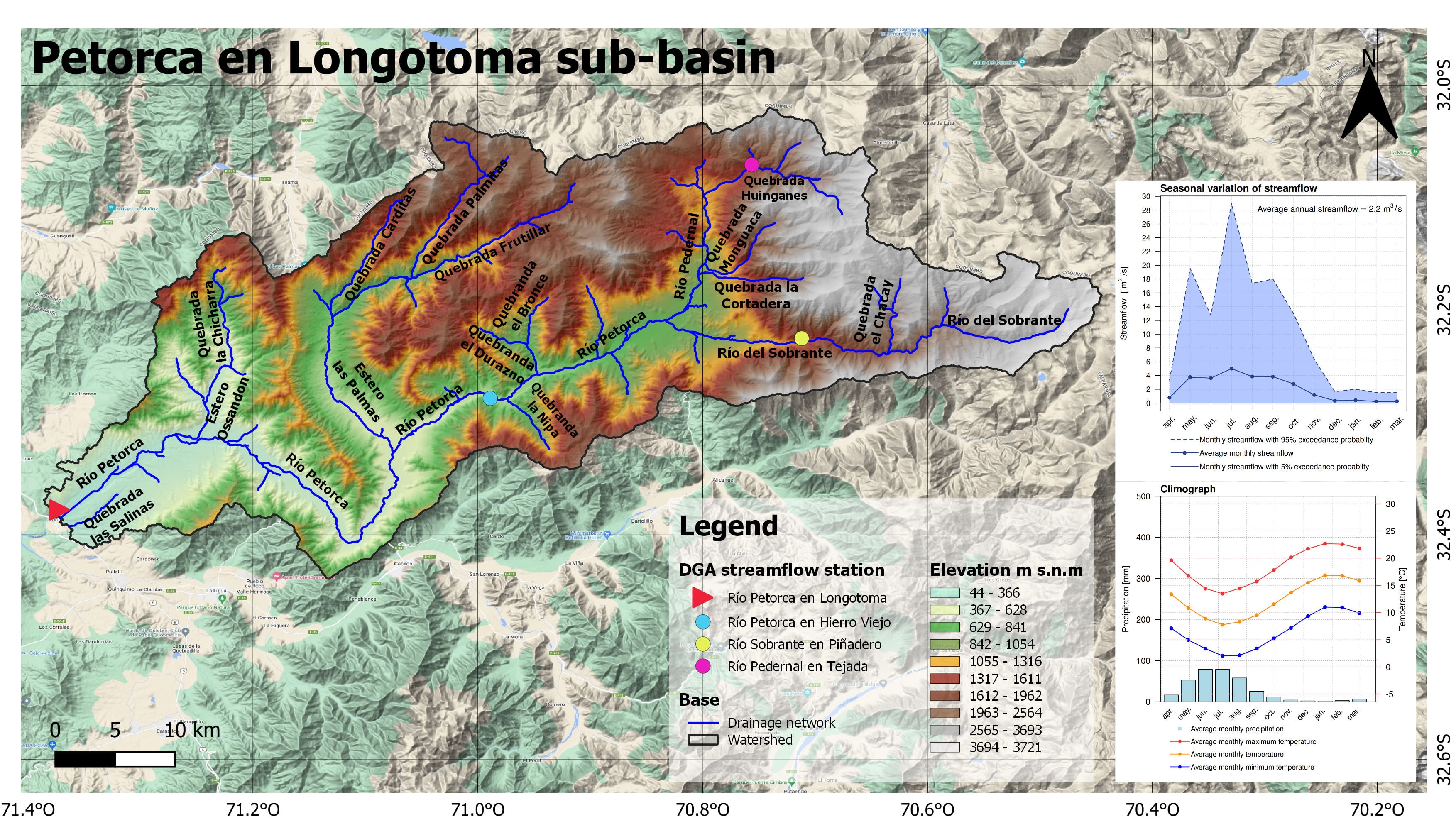
Figure 1. Elevation map of the Petorca River Basin in Longotoma.
The main sub-basins of the Petorca River are the Pedernal River in Tejada, the Sobrante River in Piñadero, and the Petorca River in Hierro Viejo, which can be seen in Figures 2, 3, and 4.
The Pedernal River sub-basin in Tejada is the smallest, with an area of 81.1 km² and elevations ranging from 1372 to 3485 meters above sea level.
The sub-basin has a snow-rain hydrological regime, characterized by higher flows in the spring months due to snowmelt. During the winter season (June, July, and August), high precipitation occurs compared to other months, but with lower flow compared to the spring season (September, October, November), when precipitation decreases as summer approaches, but flows increase due to snowmelt.
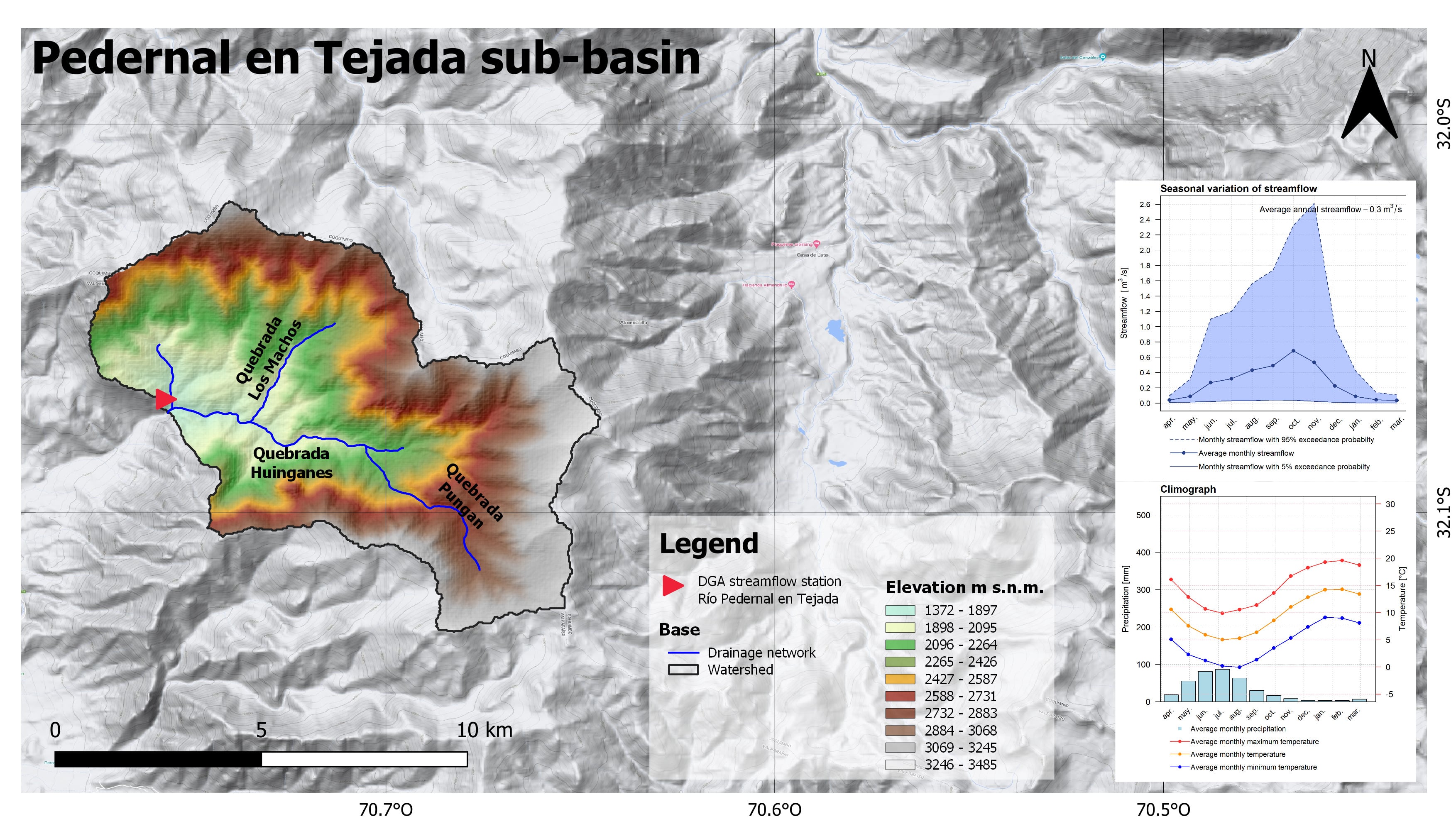
Figure 2. Elevation map of the Pedernal River Sub-basin in Tejada.
On the other hand, Figure 3 shows the Sobrante River sub-basin in Piñadero, which originates from the Sobrante Lagoon, located at about 3240 meters above sea level (DGA, 2006), and is classified as a basin with a low level of human intervention (Muñoz et al., 2020). This basin has an area of 241.1 km², with elevations ranging from 1176 to 3721 meters above sea level.
This sub-basin also has a snow-rain hydrological regime, similar to the Pedernal River sub-basin in Tejada, characterized by higher flows in the spring months compared to winter flows.
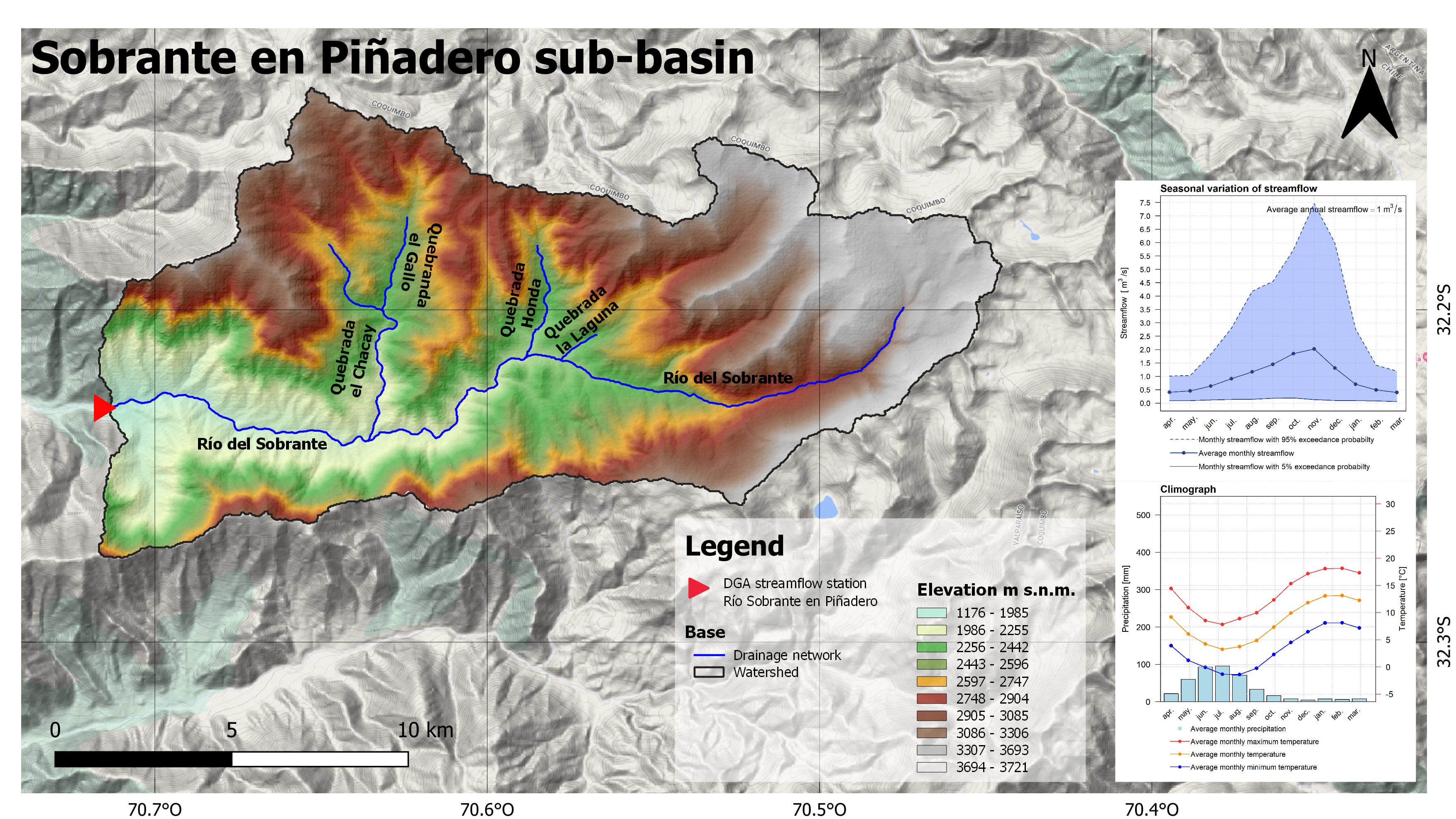
Figure 3. Elevation map of the Sobrante River Sub-basin in Piñadero.
Finally, the Petorca River sub-basin in Hierro Viejo, shown in Figure 4, includes the two previously mentioned sub-basins, making its total area 947.2 km², with elevations ranging from 453 to 3721 meters above sea level. The main tributaries are the Pedernal River and the Sobrante River.
This sub-basin has a snow-rain hydrological regime, influenced by the regimes of the Pedernal River in Tejada and the Sobrante River in Piñadero, as they are part of the area of the Petorca River sub-basin in Hierro Viejo.
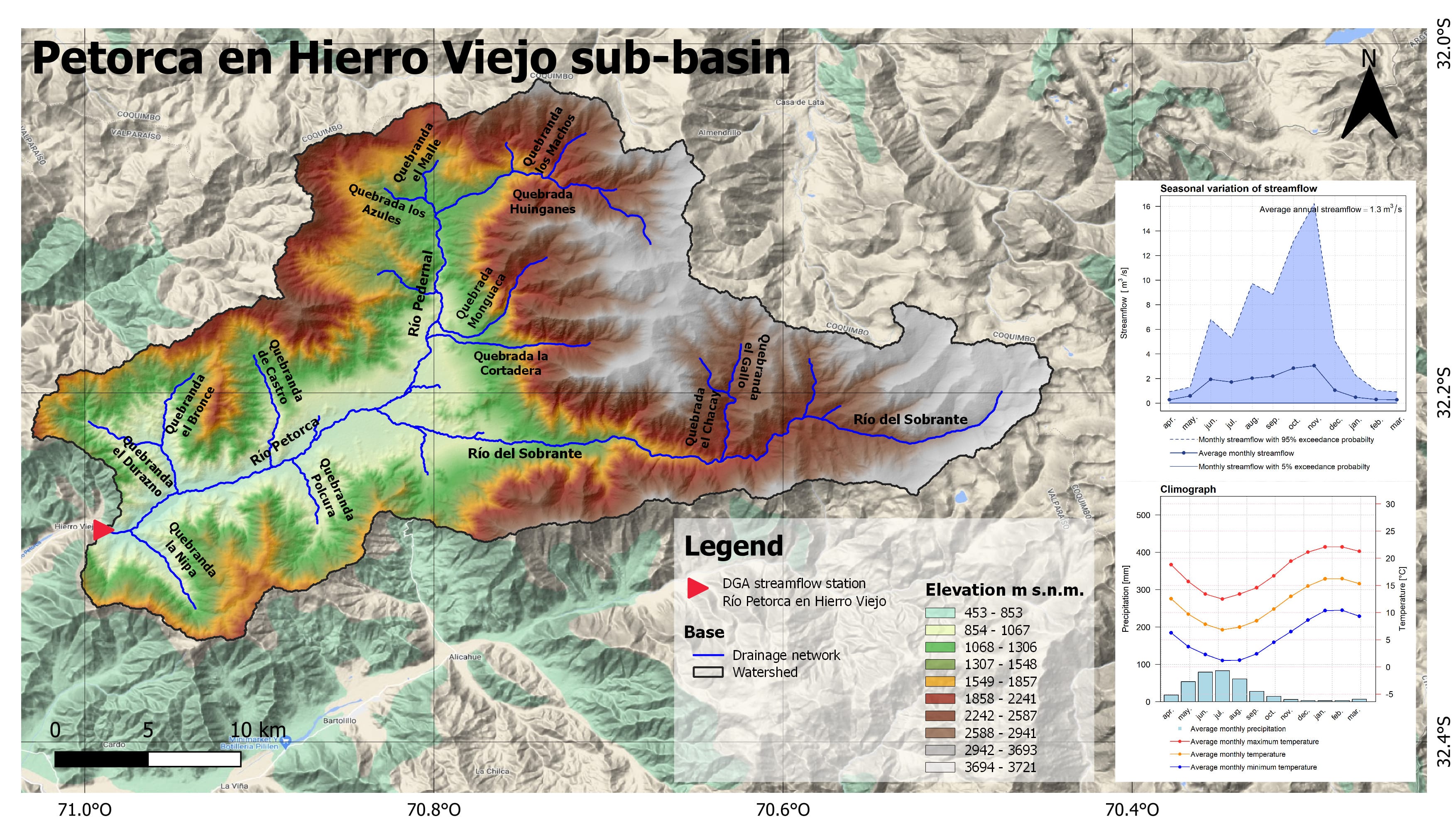
Figure 4. Elevation map of the Petorca River Sub-basin in Hierro Viejo.
Hydrography
The Petorca River originates in the Andes Mountains, at the confluence of the Pedernal River (to the north) with the Sobrante River (to the south), near the town of Chincolco (650 m above sea level). After a journey of approximately 100 km, flowing southwest with a slope of 3.22%, it empties into the sea at a place called Las Salinas de Pullally, near the mouth of the La Ligua River. Most of the tributaries are short, especially those originating from the southern slope, corresponding to the Sobrante River. The main tributaries of the Pedernal River are La Tejada and Chacalo streams, while for the Sobrante River, the main watercourses are La Laguna stream (where the Laguna del Sobrante is located), Los Nacimientos stream, and El Chacay stream. In its lower course, the Petorca River receives waters from Las Palmas and Ossandón streams, along with several other streams, including Castro, El Bronce, and Ñipa. Figure 1 shows the main watercourses of the Petorca River Basin.
The primary use of its waters is for irrigation in the Petorca Valley (BCN).
Climate
The Köppen-Geiger climate classification for the period 1980–2016 presents six climate types: BSk, CSb, Csc, Dsb, Dsc, and ET (Beck et al., 2018). The lowest part of the basin (44–1316 m above sea level) is characterized by a cold semi-arid steppe climate (BSk). As the elevation increases (up to 2565 m above sea level), a long, dry summer with mild temperatures begins (Csb, Csc). Above 2565 m, a colder but still dry climate (Dsb, Dsc) starts, and above 3694 m, tundra-type polar climates (ET) dominate, which typically feature low precipitation and average temperatures below 10°C year-round, dropping below 0°C in winter (see Figure 5).
For the period 2071–2100, a significant change in the climate of the basin is projected. In higher areas, the tundra climate (ET) will disappear, and temperatures will rise, leading to a drier climate with less snow accumulation in the upper areas. In the lower part of the basin, temperatures will increase, resulting in an arid, warm-to-hot climate, which will reduce the areas previously characterized by a cooler, semi-arid climate.
In the context of the Petorca River Basin at Longotoma, the following climate types have been identified for the present and future periods:
- BSk: Cold steppe climate, characterized by cold, dry winters and warm summers. Precipitation is generally scarce, and the vegetation is adapted to drought conditions.
- Bsh: Cold arid steppe climate, similar to BSk but with even less rainfall, resulting in a more arid and dry environment.
- Bwh: Cold desert climate, with cold, dry winters and warm summers. Precipitation is extremely scarce year-round, creating a desert environment.
- Bwk: Cold desert climate with cold winters, similar to Bwh but with colder winters and cooler summer temperatures.
- Csb: Temperate climate with dry, warm summers. Similar to the Csa climate, this type has dry, warm summers, but temperatures may be more moderate. Rainy seasons are concentrated in winter, with more noticeable drought in summer. Common in coastal regions with maritime influence.
- Csc: Temperate climate with dry, cool summers. Summers are dry and cool rather than warm. Temperatures tend to be more moderate year-round, with more precipitation in winter and less in summer. Characteristic of areas with less oceanic influence.
- Dsb: Cold climate with dry, warm summers. Similar to BSk, but with colder winters and lower temperatures. Precipitation is low throughout the year, but summers are brief and warmer than in Dsc climates. Found in cold areas with maritime influence.
- Dsc: Cold climate with dry, cool summers. Similar to Dsb, but summers are cooler rather than warm. Precipitation is low year-round, with shorter and cooler summers. Found in cold areas with maritime influence.
- ET: Polar tundra climate, found in polar regions with extremely low temperatures year-round. Summers are very short and cold, with tundra vegetation adapted to the cold climate.
These climate categories are essential for understanding and describing the distinct characteristics of the region’s climate, both in the present and in future projections. Analyzing climate trends is vital for decision-making in planning and adaptation to potential climate changes.
Figure 5. Köppen-Geiger climate classification map of the Petorca River Basin in Longotoma for the present (1980–2016) and future (2071-2100). Source: Beck et al., 2018.
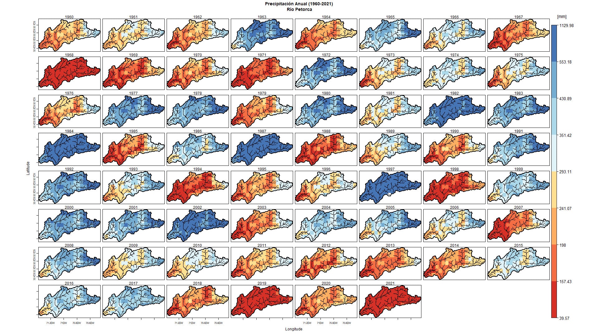
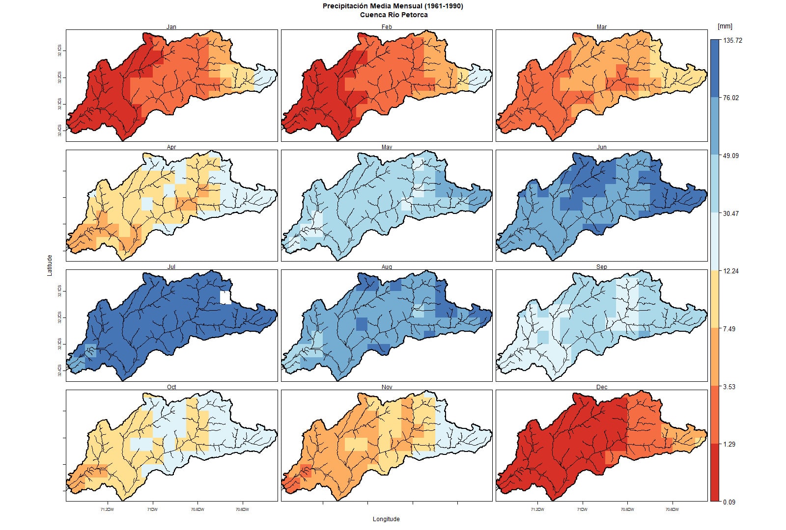
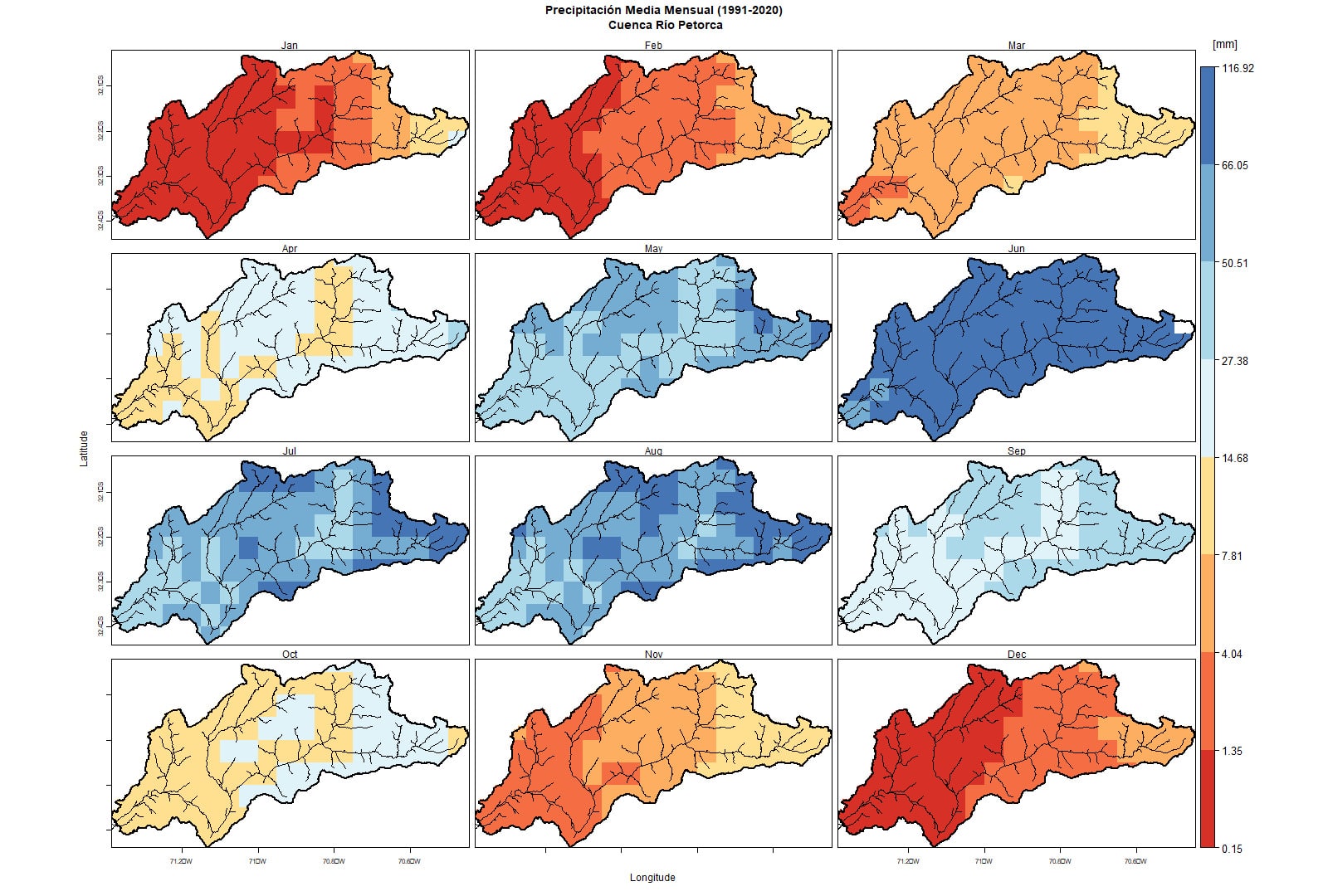
Figure 6. Spatial distribution of precipitation in the Petorca River Basin. Prepared from CR2METv2.5 data.
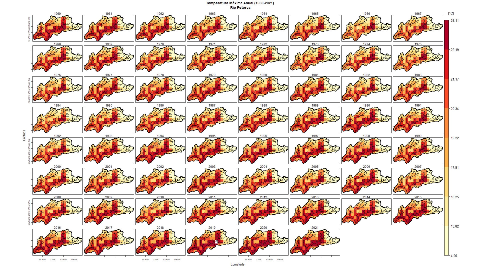
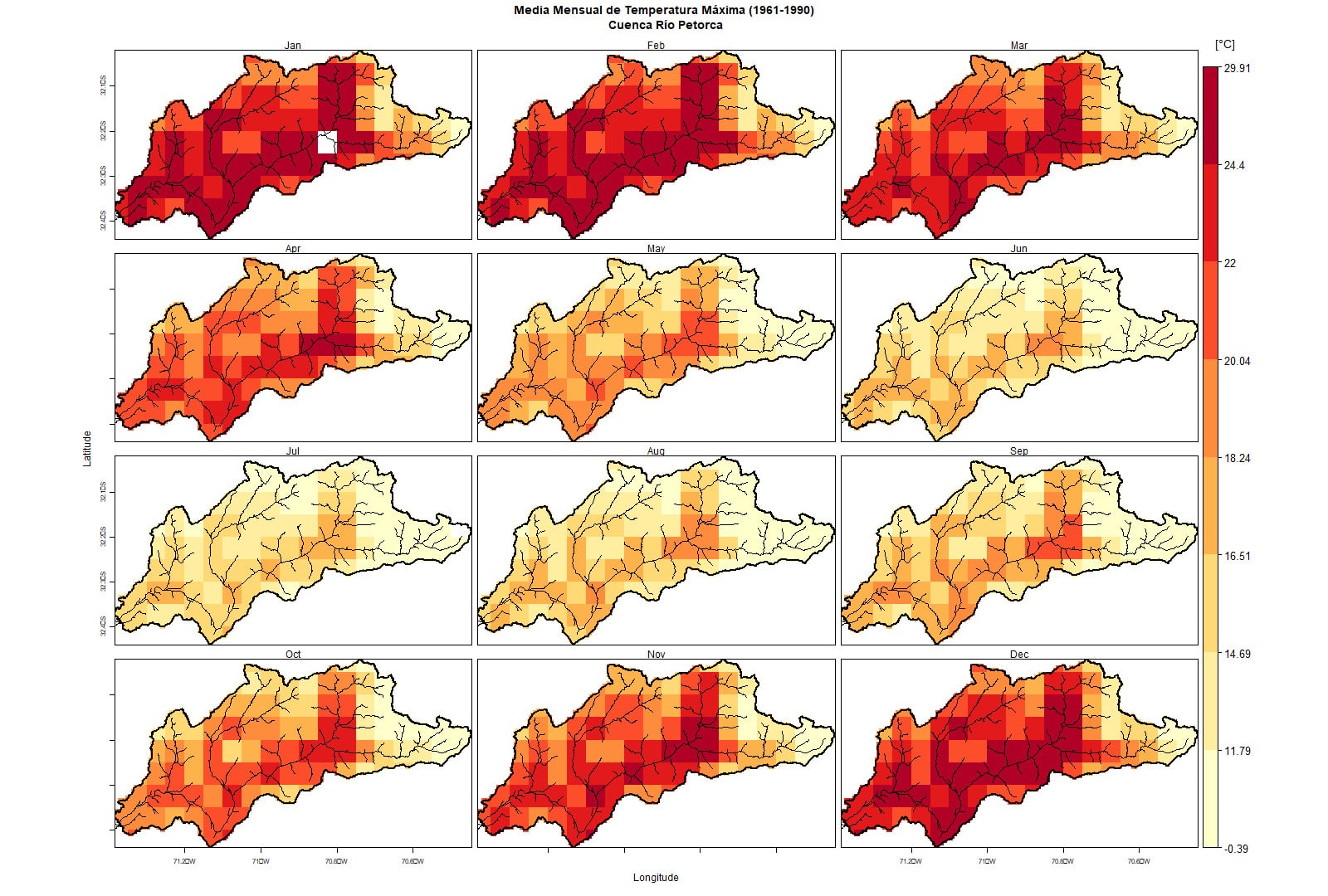
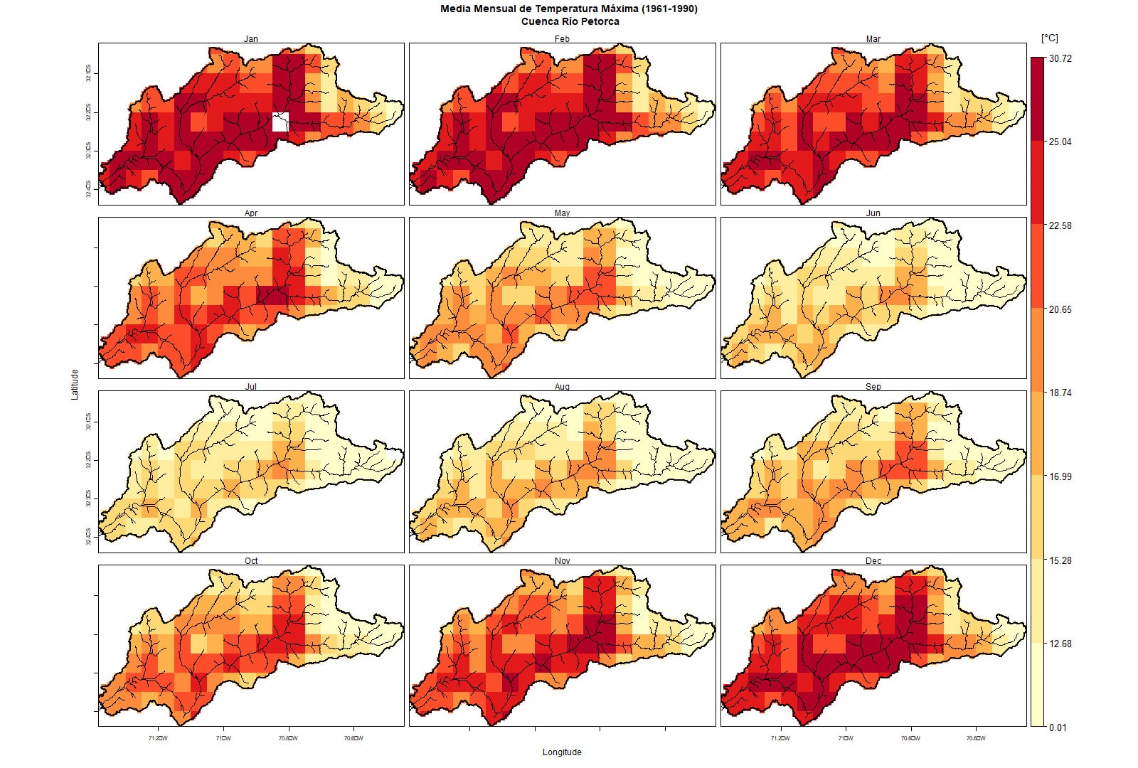
Figure 7. Spatial distribution of the Maximum Temperature in the Petorca River Basin. Prepared from CR2METv2.5 data.
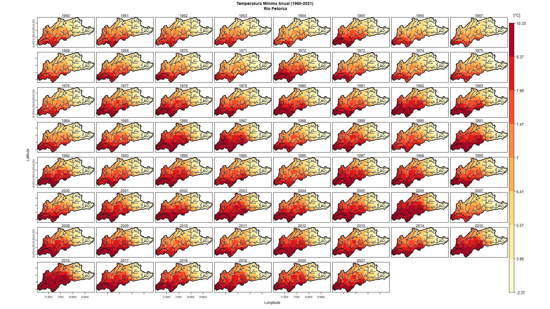
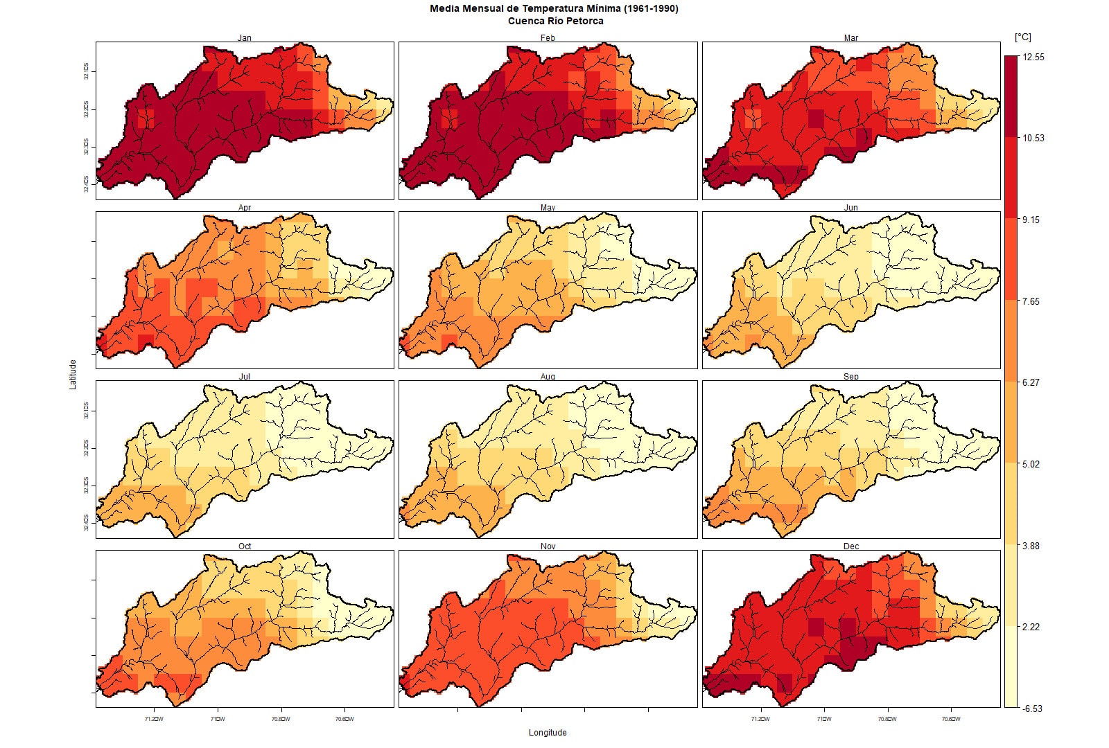
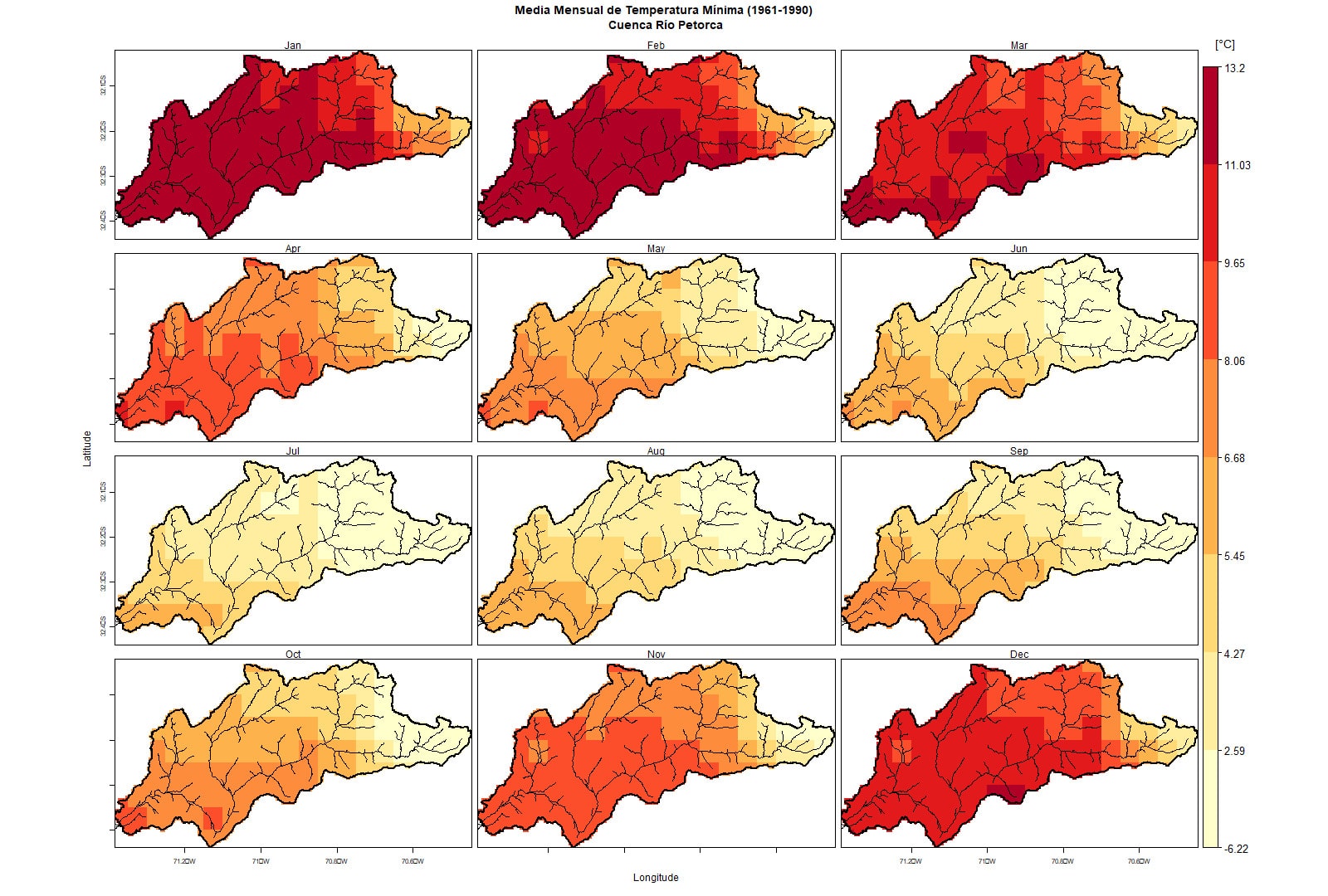
Figure 8. Spatial distribution of the Minimum Temperature in the Petorca River Basin. Prepared from CR2METv2.5 data.
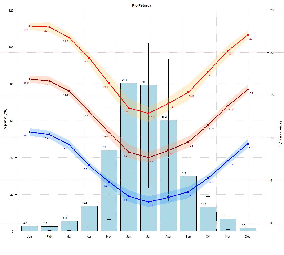
Figure 9. Climogram of the Petorca River Basin. Prepared from CR2METv2.5 data.
Land Use
87% of the watershed is covered by shrubland and bush-type vegetation, largely due to the semi-arid climate present in the region. In some specific areas, such as the lower part of the watershed, there are high-altitude desert areas with sparse or no vegetation, similar to the high-elevation zones.
Figure 10. Land use map of the Petorca Basin in Longotoma. Source: Ceballos et al. (2021) y Galleguillos et al. (2024).
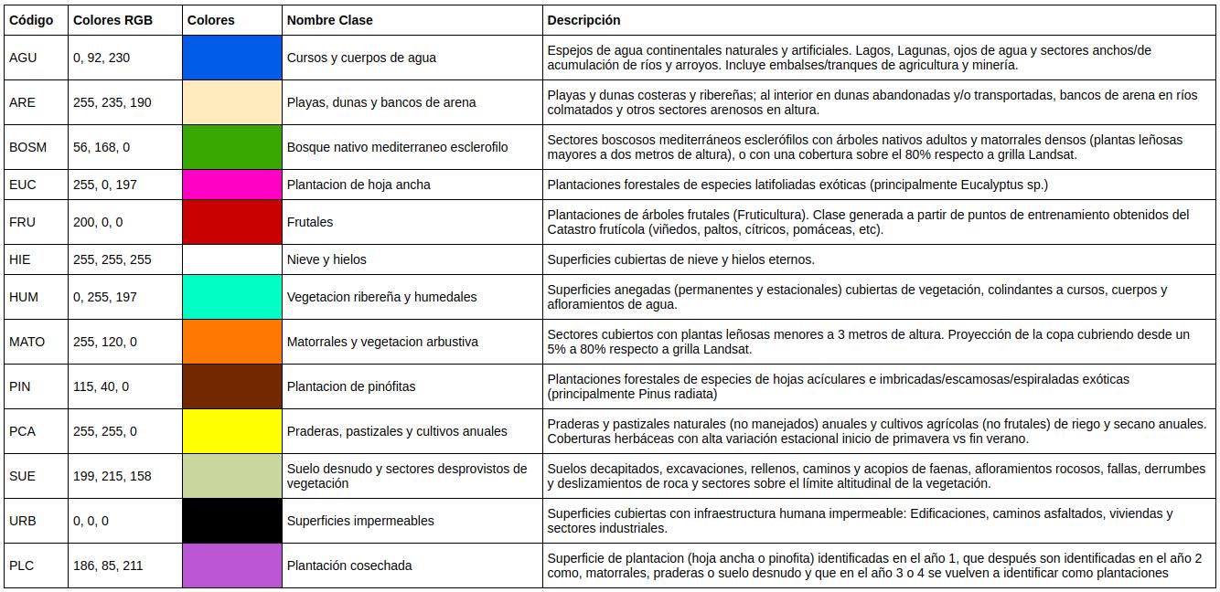
Table 1. Descriptive table of land cover in the Petorca River Basin in Longotoma.
Soil Type
Figure 11 presents the soil characterization based on depth, showing that at depths between 0 and 5 cm, the soil is predominantly sandy loam (LoSa), with a high sand content (80%), but also containing 15% silt and 10% clay. Additionally, there is a significant percentage of sandy loam soil (SaLo), containing 65% sand, 25% silt, and 10% clay.
As soil depth increases (from 5 to 15 cm), a reduction in sandy loam (LoSa) is observed, while sandy clay loam (SaClLo) increases. The latter consists of 35% sand, 35% silt, and 30% clay. This results in a decrease in sand and an increase in silt compared to surface soil.
At depths between 15 and 30 cm, a significant reduction in sandy loam (SaLo) is noted, with an increase in sandy clay loam (SaClLo). Additionally, in the lower part of the basin, sandy loam (LoSa) reappears.
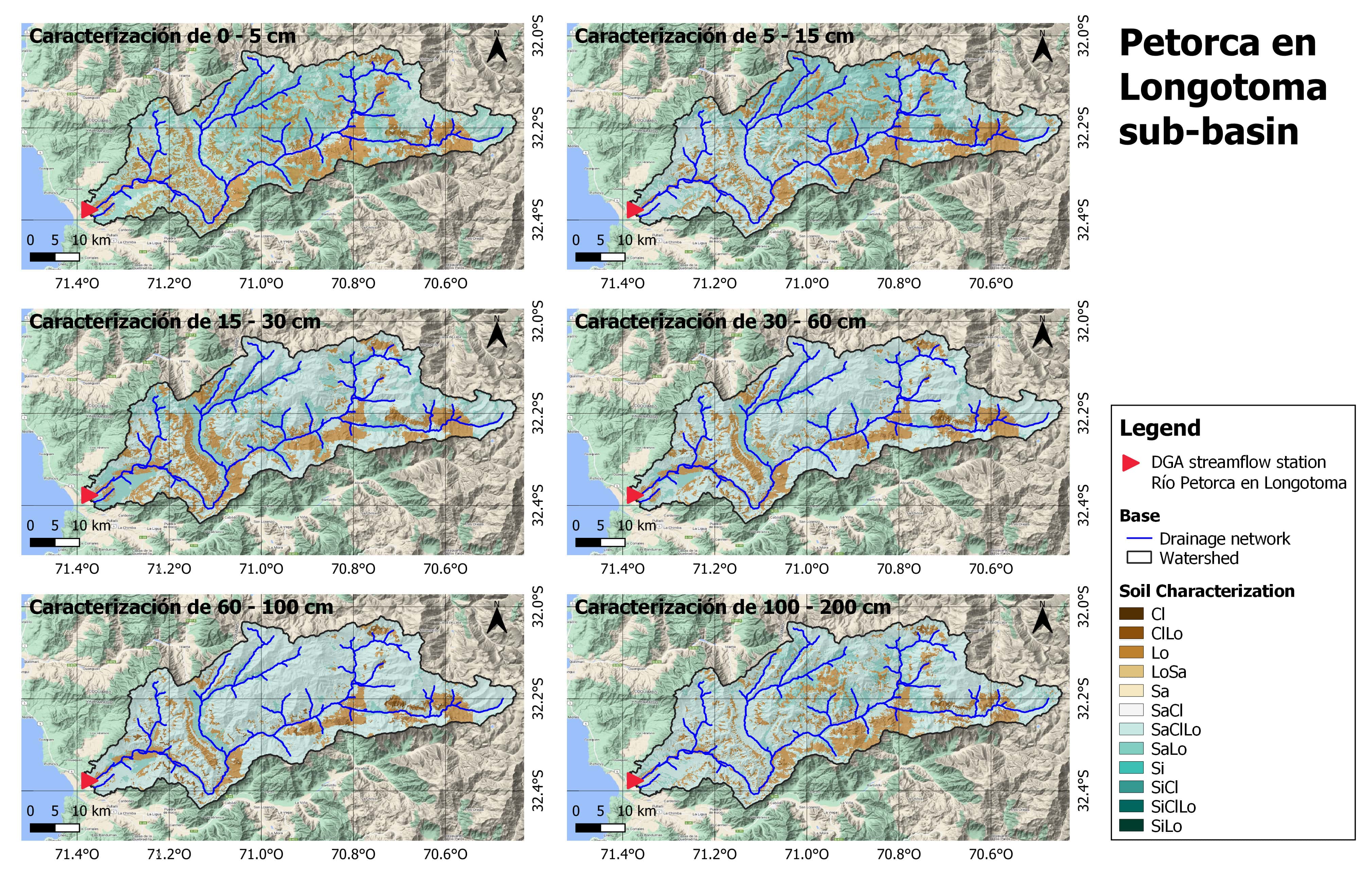
Figure 11. Soil type map of the Petorca River Basin in Longotoma. Source: Galleguillos et al., 2022
Geology
The lower part of the basin features volcanic and marine sedimentary sequences from the Jurassic period. In the middle section, sedimentary and volcanic sequences from the Lower Cretaceous period dominate, with andesite and basalt formations, which are prominent in the coastal mountain range between the Atacama and Metropolitan regions. Finally, in the upper part of the basin (sub-basins of the Sobrante River in Piñadero and the Pedernal River in Tejada), continental volcanic-sedimentary sequences prevail. At the highest point of the Sobrante River sub-basin, volcanic rocks generated in an intrusive environment are found, while at the confluence of the Pedernal River with the Sobrante River, continental sedimentary and volcanic sequences are observed (Peña, 2021).
Water Resources
Water use in the basin is mainly allocated to agriculture, which is developed in areas near river valleys, with avocado and lemon plantations prevailing (Peña, 2021). This is largely due to land purchases at low prices since the 1990s, which led to an excessive granting of provisional water rights by the DGA, resulting in a constant increase in water use and over-exploitation of the basin.
Due to constant water extractions by agricultural entrepreneurs, Petorca is currently experiencing a progressive water crisis (Panez-Pinto, Faúndez & Mansilla, 2017). It is projected that drought scenarios will persist and worsen (Morgan, 2020).
Currently, much of the Petorca population relies on water delivery trucks for their supply. This is due to several factors, including the uninterrupted Mega Drought since 2010, which has caused an annual decrease in precipitation, river flows, reservoir volumes, and groundwater levels (Garreaud et al., 2017).
Monitoring Points
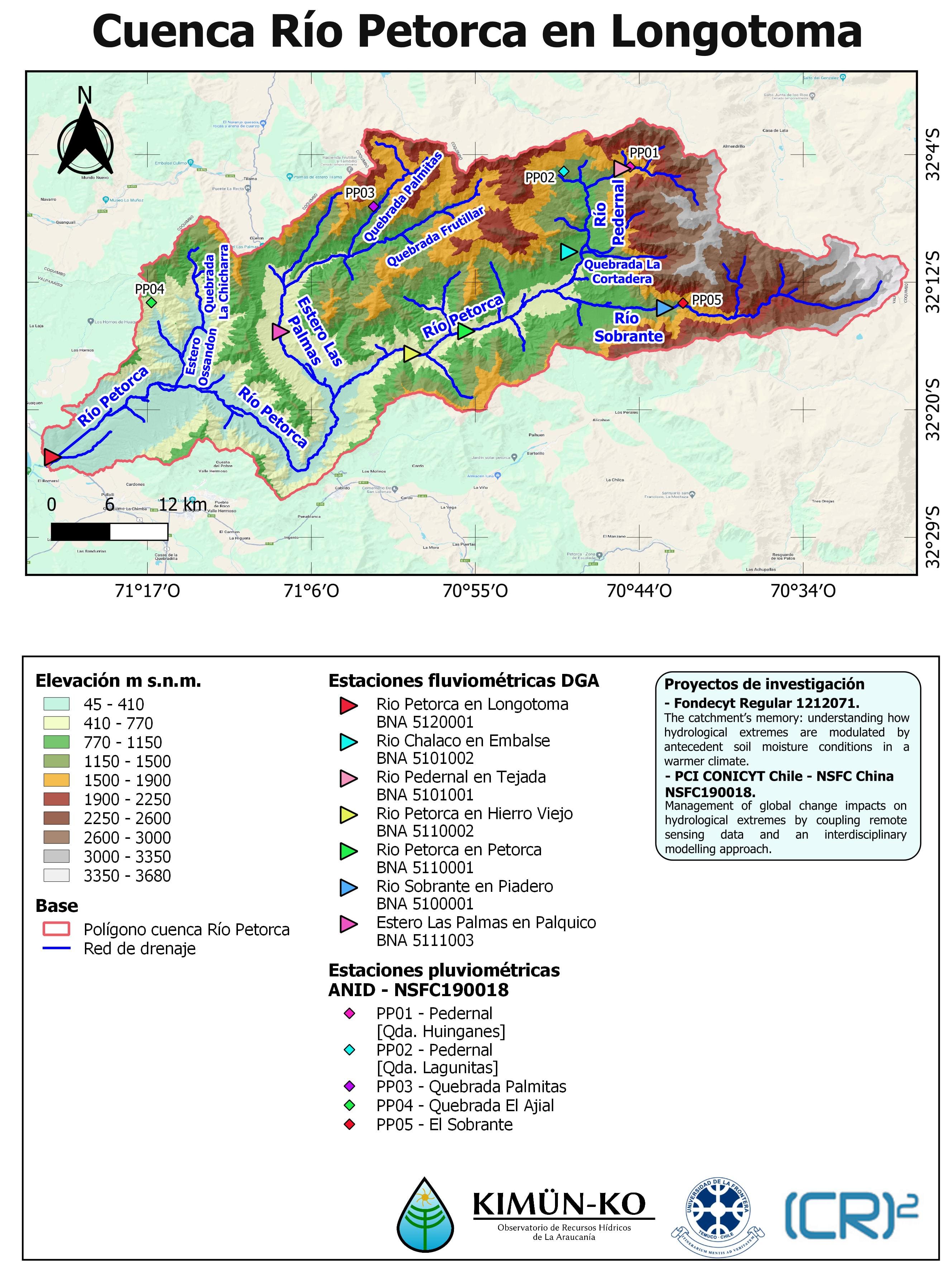
Figure 12. Precipitation monitoring points.
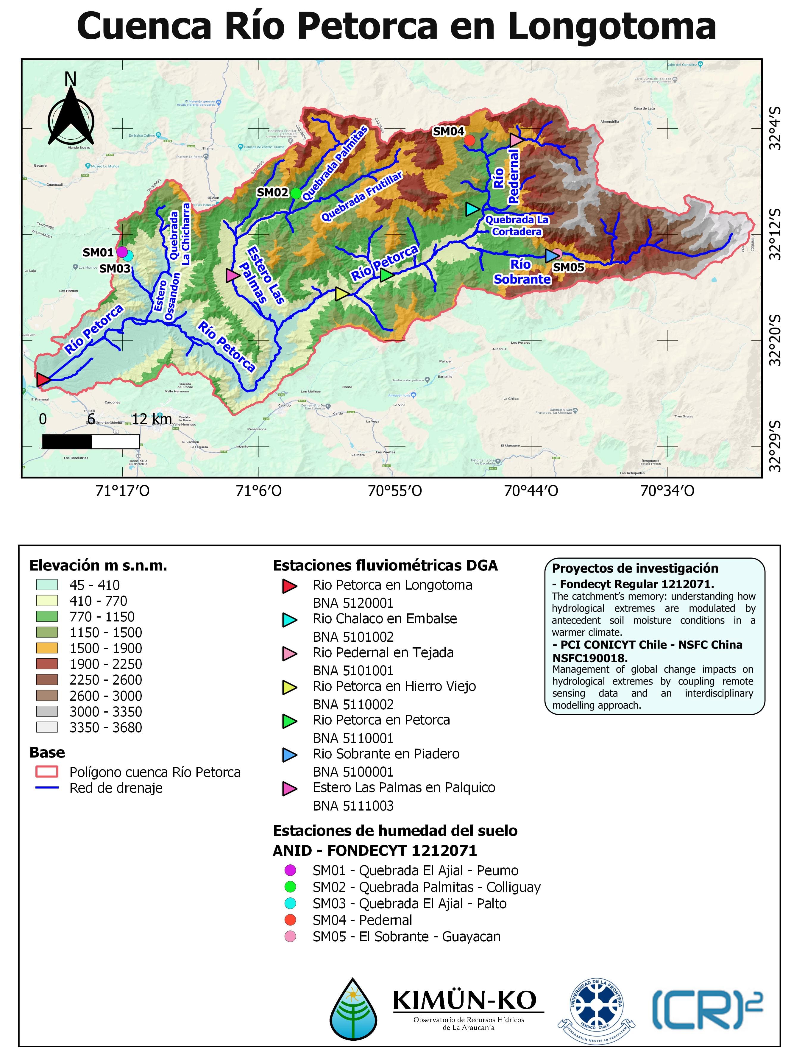
Figure 13. Soil moisture monitoring points.
Precipitation Intensity-Duration Curves
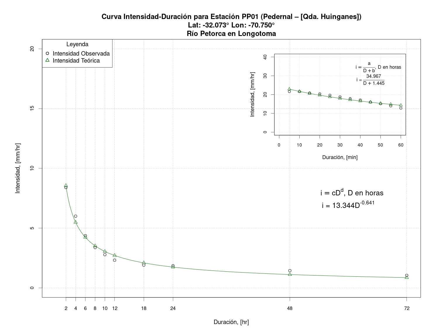
Figure 14. Intensity-Duration curve for Pedernal Station - Quebrada Huinganes (PP01).
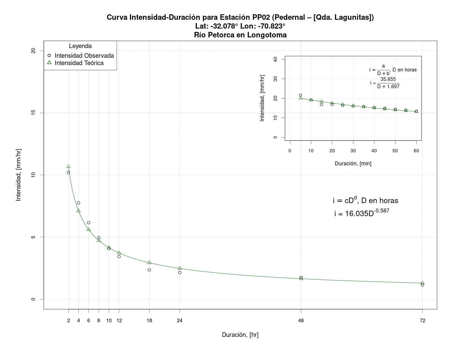
Figure 15. Intensity-Duration curve for Pedernal Station - Quebrada Lagunitas (PP02).
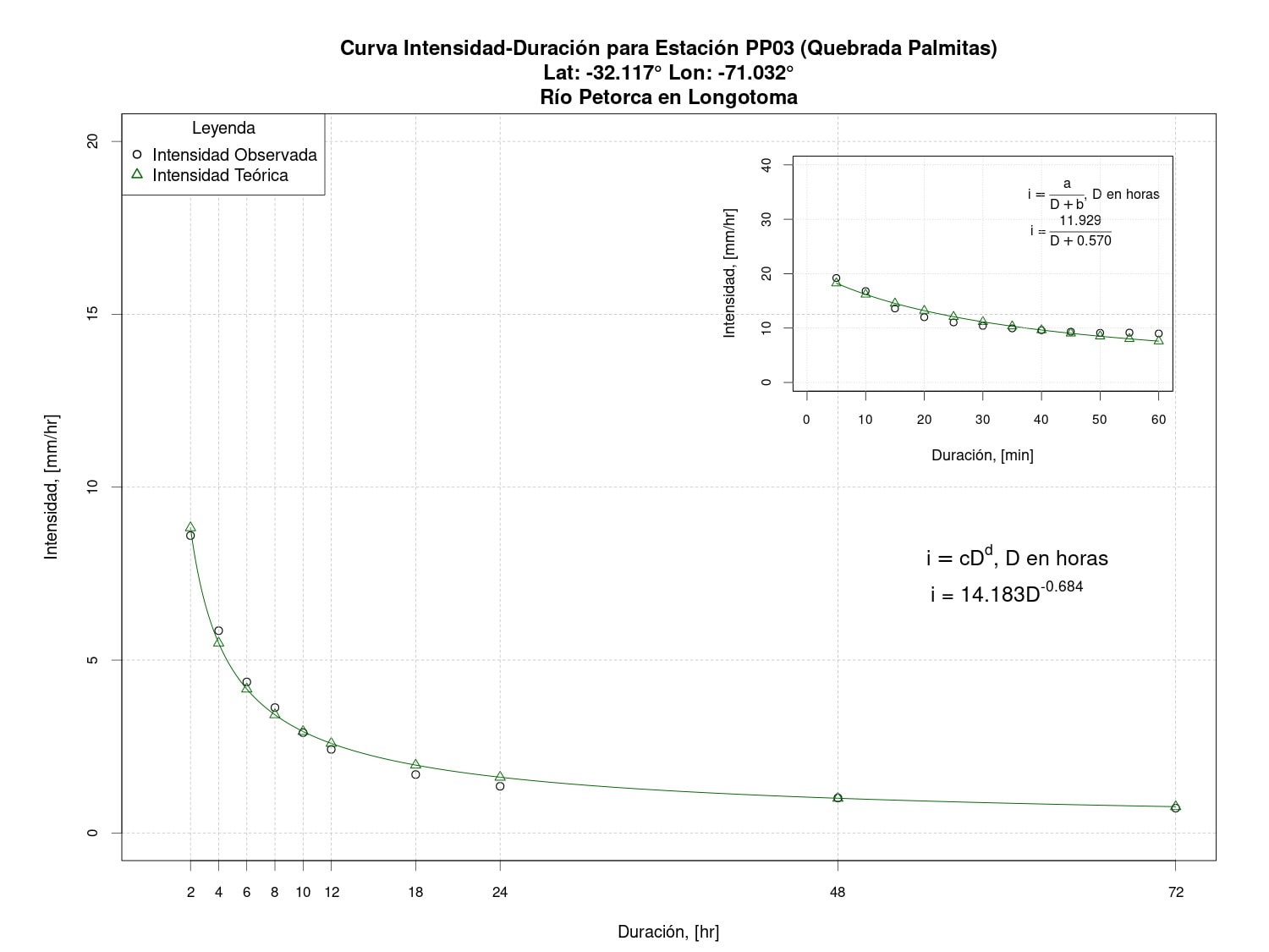
Figure 16. Intensity-Duration curve for Quebrada Palmitas Station (PP03).
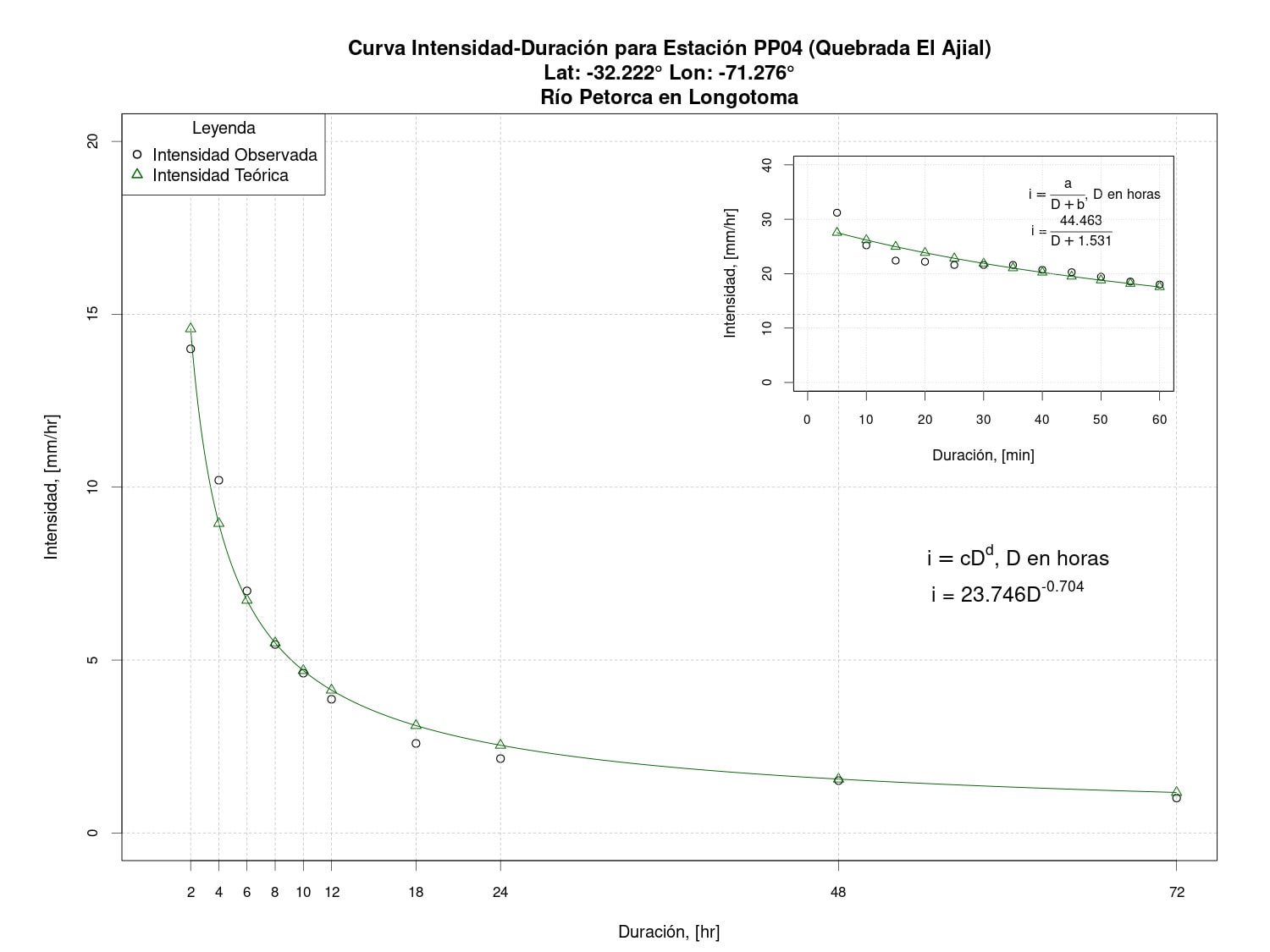
Figure 17. Intensity-Duration curve for Quebrada El Ajial Station (PP04).
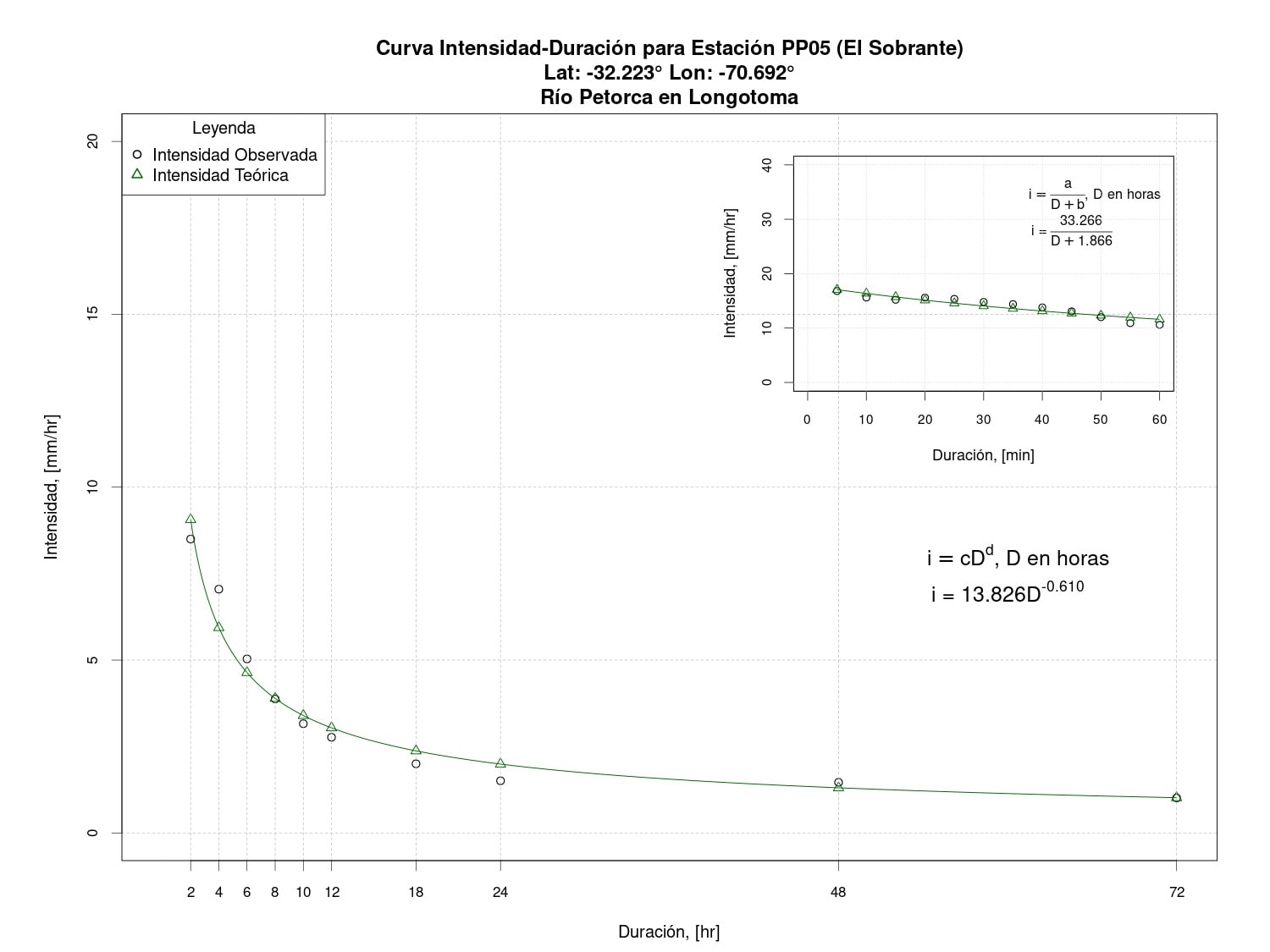
Figure 18. Intensity-Duration curve for El Sobrante Station (PP05).
Water Rights
According to the General Directorate of Water (DGA, 2023), responsible for granting Water Rights (DAA), a total of 2,053 DAAs are registered in its database for the Petorca River Basin, all of which correspond to consumptive rights.
Photos
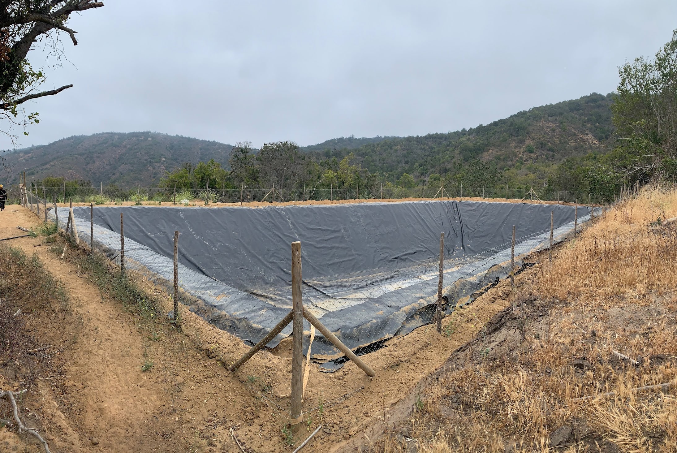
![PP01 - Pedernal [Qda. Huinganes]](/assets/images/petorca/PP01.jpg)
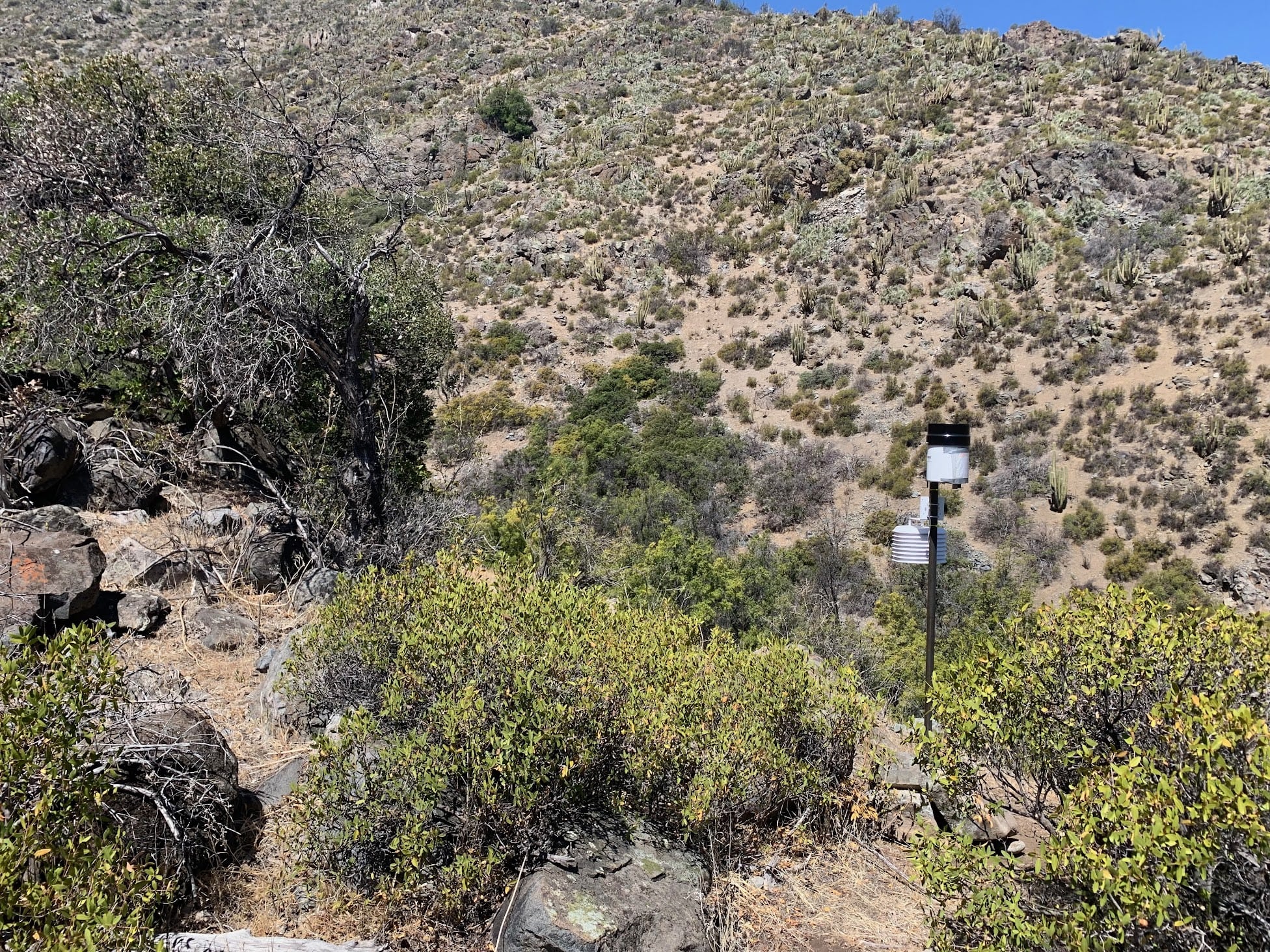
![PP02 - Pedernal [Qda. Lagunitas]](/assets/images/petorca/PP02.jpg)
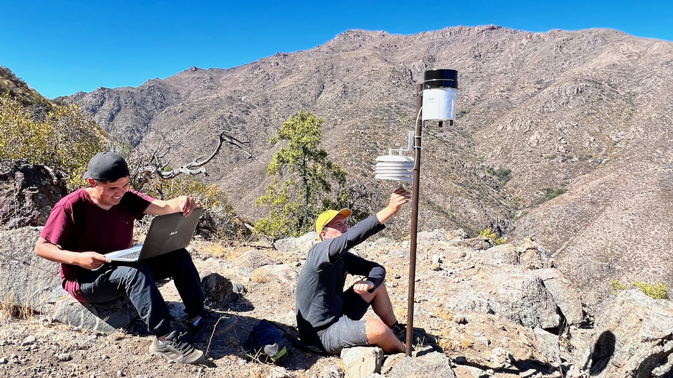
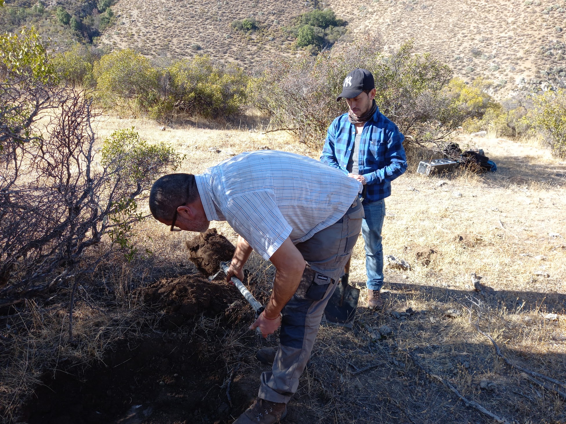
![SM01 - Qda El Ajial [Peumo]](/assets/images/petorca/SM01.jpg)
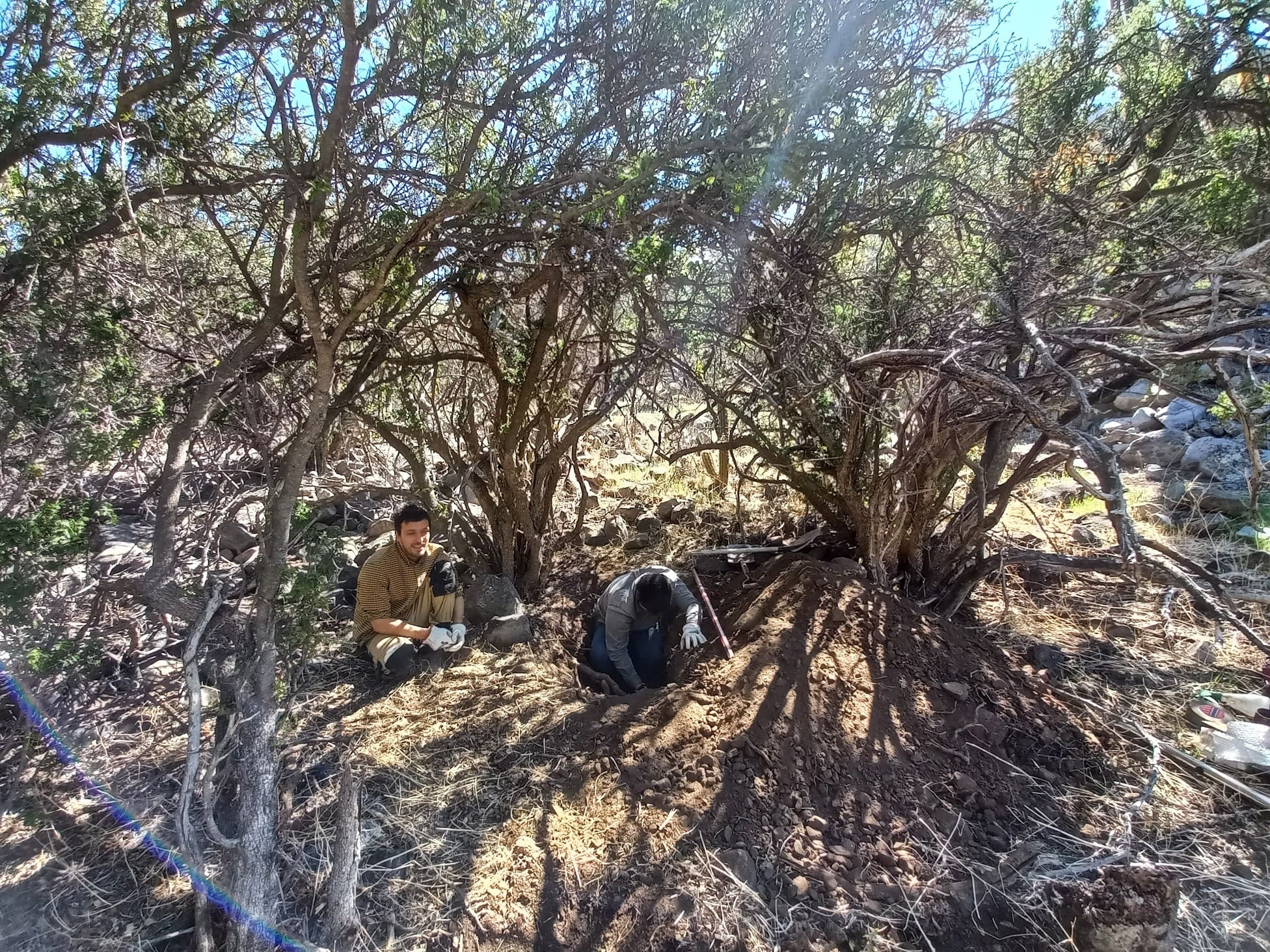
![SM03 - Qda El Ajial [Palto]](/assets/images/petorca/SM03.jpg)
![SM04 - Morro de Chivato [Pedernal]](/assets/images/petorca/SM04.jpg)
Relevant references:
- Iñiguez, B. (2021). Huella hídrica del proceso productivo de paltos en la Cuenca de Petorca-La Ligua: análisis de su sostenibilidad. Memoria para optar al título profesional de Ingeniero en Recursos Naturales Renovables. Universidad de Chile, Facultad de Ciencias Agronómicas, Escuela de Agronomía. Santiago, 2021.
- Madariaga, A.; Maillet, A.; Rozas, J. (2021). Multilevel business power in environmental politics: the avocado boom and water scarcity in Chile. Environmental Politics, 1-22. doi:10.1080/09644016.2021.1892981.
- Peña, M. (2021). Análisis del efecto de la intensificación en la fruticultura de riego sobre el balance hídrico de la Cuenca de Petorca, Chile. REPOSITORIO ACADÉMICO de la Universidad de Chile.
- Rojas, R. A. G., & Fragkou, M. C. (2021). ¿Infraestructura ante la crisis hídrica? Políticas de Estado en los ríos Petorca y La Ligua1. Pandemia y miedo: Una reflexión preliminar, Cuad Méd Soc. 61(1), 61-71.
- Muñoz, A.A.; Klock-Barría, K.; Alvarez-Garreton, C.; Aguilera-Betti, I.; González-Reyes, Á.; Lastra, J.A.; Chávez, R.O.; Barría, P.; Christie, D.; Rojas-Badilla; M. and Quesne, C.L. (2020). Water Crisis in Petorca Basin, Chile: The Combined Effects of a Mega-Drought and Water Management. Water, 12(3), p.648. doi:10.3390/w12030648
- Bolados, M. (2020). El ciclo antisocial del agua: injusticia hídrica en la provincia de Petorca. Memoria para optar al título de Geógrafa. Universidad de Chile, Facultad de Arquitectura y Urbanismo, Departamento de Geografía. Santiago, 2020.
- Ceballos-Comisso, A.; Galleguillos, M.; Gimeno, F.; Lara, A. (2021). A semi-automatic algorithm for historical Land Cover Mapping in a complex dynamic landscape of central Chile. Technical report.
- Galleguillos, M., Ceballos-Comisso, A., Gimeno, F., & Zambrano-Bigiarini, M. (2024). CLDynamicLandCover [Data set]. Zenodo. https://doi.org/10.5281/zenodo.13153631
- Morgan, M. (2020). La escasez hídrica y su medida de mitigación en la cuenca del Río Petorca: una evaluación a partir de la experiencia de comités de agua potable rural. Tesis para optar al grado de Magíster en Geografía. Universidad de Chile, Facultad de Arquitectura y Urbanismo, Magíster en Geografía. Santiago, 2020.
- Fragkou, M. C., & Budds, J. (2019). Desalination and the disarticulation of water resources: Stabilising the neoliberal model in Chile. Transactions of the Institute of British Geographers, 45(2), 448-463. doi:10.1111/tran.12351
- Rybertt, J.A. (2019). Hidrogeología y modelo conceptual del acuífero de Petorca en el sector alto de la cuenca del río Petorca, región de Valparaíso. Memoria de pregrado para optar al título de Geóloga. Universidad Nacional Andrés Bello, Departamento Geología. Viña del Mar, 2019.
- López, O.A. (2019). Identificación de áreas con posible extracción ilegal de agua en la cuenca de Petorca, Chile, mediante la estimación de áreas agrícolas sin derechos de aprovechamiento de agua asignados. Memoria para optar al título de Ingeniero Civil. Universidad de Chile, Facultad de Ciencias Físicas y Matemáticas, Departamento de Ingeniería Civil. Santiago, 2019.
- Miranda, F. (2018). Erosión de Suelos y Crisis Hídrica: Las Sombras del Modelo Agroexportador de Palto. Septiembre 2018. Fundación TERRAM. Santiago, Chile.
- DGA (2019). Actualización de la modelación del sistema acuífero la Ligua-Petorca. Resumen ejecutivo. Realizado por AC Ingenieros. S.I.T. Nº442. Santiago, agosto 2019.
- DGA (2018). Evaluación del actual nivel de explotación de los acuíferos de la Ligua y Petorca. Ministerio de Obras Públicas, Dirección General de Aguas, Departamento de Administración de Recursos Hídricos. S.D.T. 415. Santiago, Mayo 2018.
- DGA (2013). Actualización informe evaluación de los recursos hídricos superficiales de las cuencas del río Petorca y río La Ligua, Región de Valparaíso : informe técnico. Ministerio de Obras Públicas, Dirección General de Aguas, Departamento de Administración de Recursos Hídricos. S.D.T. 340. Santiago, Junio 2013.
- DGA (2006). Evaluación de los recursos hídricos superficiales de las cuencas de los ríos Petorca y La Ligua, V Región. Ministerio de Obras Públicas, Dirección General de Aguas, Departamento de Administración de Recursos Hídricos. S.D.T. 226. Santiago, Abril 2006.
- Bolados, P., Henríquez, F., Ceruti, C., & Cuevas, A. S. (2018). An Eco-Geo-Politic of Water: A proposal from the Territories in the Struggles for the Reclamation df Water in Petorca Province (Central Zone of Chile). Revista Rupturas, 8(1), 159-191. doi:10.22458/rr.v8i1.1977.
- Panez-Pinto, A., Mansilla-Quiñones, P., & Moreira-Muñoz, A. (2018). Water, soil and sociometabolic fracture of agribusiness. Fruit activity in Petorca, Chile. Bitácora Urbano Territorial, 28(3), 153-160. doi:10.15446/bitacora.v28n3.72210.
- Garreaud, R. D., Alvarez-Garreton, C., Barichivich, J., Boisier, J. P., Christie, D., Galleguillos, M., LeQuesne, C., McPhee, J., and Zambrano-Bigiarini, M. (2017). The 2010-2015 megadrought in central Chile: impacts on regional hydroclimate and vegetation. Hydrology and Earth System Sciences, 21(12), 6307-6327.
- Panez-Pinto, A., Faúndez-Vergara, R., Mansilla-Quiñones, C. (2017). Politización de la crisis hídrica en Chile: Análisis del conflicto por el agua en la provincia de Petorca. Agua y Territorio / Water and Landscape, (10), 131-148. doi:10.17561/at.10.3614.
- Guiloff, M. (2013). El derecho al agua como derecho humano: el caso de la provincia de Petorca. In Informe anual sobre derechos humanos en Chile 2013 (pp. 255-284). Universidad Diego Portales.
- CNR (2016). Estudio básico diagnóstico para desarrollar plan de riego en las cuencas de los ríos La Ligua y Petorca : informe final. Realizado por Departamento de Recursos Hídricos, Facultad de Ingeniería Agrícola, Universidad de Concepción. CNR-0453.
- CNR (2013). Mejoramiento de agua subterránea para riego Ligua y Petorca. Realizado por GCF Ingenieros Ltda. CNR-0364.
- CNR (2011). Estudio diagnóstico de los recursos subterráneos en el sistema Ligua y Petorca : informe final.. Realizado por GCF Ingenieros Ltda. CNR-0346
- Guiloff, M. (2013). El derecho al agua como derecho humano: el caso de la provincia de Petorca. In Informe anual sobre derechos humanos en Chile 2013 (pp. 255-284). Universidad Diego Portales.
- Velasco, M., Pohl, N., & Nieto, I. (2005). Water Issues in Chile: How Does a Dry River Sound.
- IPLA (1996). Análisis uso actual y futuro de los recursos hidricos de Chile, Vol II Regiones V, M, VI, VII. Realizado por IPLA LTDA. Enero 1996. SIT Nº26.
- Ceballos-Comisso, A., Galleguillos, M., Gimeno, F., Lara, A. (2021) An semi-automatic algorithm for historical Land Cover Mapping in a complex dynamic landscape of central Chile. in press.
- Galleguillos, Mauricio, Dinamarca, Diego, Seguel, Oscar, & Faundez, Carlos. (2022). CLSoilMaps: A national soil gridded product for Chile [Data set]. In Earth Science System Data (Version V1). Zenodo. https://doi.org/10.5281/zenodo.7464210
Related videos:
- Servicio País (2020). PETORCA cuando el río suena. Documental de Fundación Superación de la Pobreza - Servicio País. Marzo 20, 2020.
- Deutsche Welle Español (2019). Al rescate del agua en Chile. Diciembre 13, 2019.
- Muy Buenos Días TVN (2019). Guerra del agua en Petorca: ¿Por qué solo algunos tienen agua?. Octubre 7, 2019.
- BBC News (2019). ¿Agua o aguacates? El conflicto por la palta, el oro verde de Chile. Junio 14, 2019.
- RT en Español (2019). Las lágrimas secas de Chile. enero 21, 2019.
- Deutsche Welle Documental (2018). El aguacate - El lado oscuro del superalimento. Mayo 4, 2018. (notese la explicación de agua como bien pública, minuto 23)
- Secos TV (2016). Secos: documental (2016). Diciembre 12, 2016.
Related news:
- BíoBío (2021). Embalse Las Palmas: concesionaria pide suspender contrato por insuficiencia de agua en Petorca. Sep, 3, 2021.
- Alvarado, R. (2022).Desigualdad hídrica en Petorca: Estudio revela que proveedores de agua de camiones aljibe son agricultores de la misma zona. Comunicaciones FAU, Universidad de Chile. Febrero 11, 2022.
- Mongbay (2021). “Te vamos a matar, déjate de ‘hueviar’ por el agua”. Entrevista a Verónica Vilches, defensora del agua en Chile. Junio 21, 2021.
- MinDesarrollo (2020). Crisis Hídrica: Desarrollo Social y Familia sigue aplicando la Ficha Básica de Emergencia Hídrica en la comuna de Petorca. Feb 25, 2020.
- UDP-Vergara240 (2020). Mercado del agua: el rentable negocio de un empresario que vendió en $184 millones al Estado derechos de agua en Petorca. Dic 21, 2020.
- Diario El Día (2020). Entra en vigencia la nueva Ley de Servicios Sanitarios Rurales. Nov 23, 2020.
- Chloris Chilensis (2020). Fundamentos Científicos acerca del Impacto Ambiental del Otorgamiento de Planes de Manejo de Corta de Vegetación Nativa para la Recuperación de Terrenos con Fines Agrícolas. Jul 31, 2020.
- Barraza, J. (2020). Policy brief (CR)2: Crisis hídrica en la cuenca de Petorca: una combinación entre la megasequía y el manejo del agua. Mayo 18, 2020.
- BBC News Mundo. (2021). Petorca, el pueblo de Chile que está cerrando escuelas por culpa de la sequía. Diciembre 16, 2021.
- Mundo Agropecuraio (2020). Estudio es concluyente: Cultivo de paltos en Chile es positivo y contribuye medioambiental y socialmente. Oct 20, 2020.
- Portal del Campo (2020). Estado del arte ambiental de plantaciones de Persea americana Mill (palto) en Chile. Oct 14, 2020. Estudio CAZALC
- CNN Chile (2020). Petorca: INDH ingresa recurso de protección por escasez de agua durante la pandemia del COVID-19. May 22, 2020.
- El Diario de La Ligua (2020). Para enfrentar a la crisis hídrica: Gobernadora de Petorca encabezó la entrega de estanques acumuladores de agua. Ago 28, 2020.
- La Tercera (2020). Petorca: Vivir la pandemia en medio de la peor sequía en 700 años. Abril 22, 2020.
- Deutsche Welle Español (2019). Al rescate del agua en Chile. Diciembre 13, 2019.
- El Mostrador (2019). Todo sigue igual: especialistas aseguran que la crisis del agua en Petorca ha empeorado. Mar 22, 2019.
- INDH (2019). INDH sostiene que persiste crisis hídrica en Petorca. Ene 10, 2019.
- CIPER (2019). Petorca, El Kilómetro Cero
- Deutsche Welle (2019). Chileno premiado en Alemania por luchar por el derecho al aguacate. 22 Sep, 2019.
- Fundación Terram (2018). Erosión de suelos y crisis hídrica: las sombras del modelo agroexportador de palto. Oct 29, 2018.
- DGA (2018). Ministerio de Obras Públicas impulsa Plan Agua para Petorca que contempla 28 medidas de gestión, fiscalización e inversión por $15.600 millones. Ago 21, 2018.
- MODATIMA (2018). Un plan hídrico para Petorca a la medida de los usurpadores - Declaración Pública. Ago 21, 2018
- CIPER (2018). La naturaleza política de la sequía en Petorca. Abr 27, 2018.
- The Guardian (2018). Chilean villagers claim British appetite for avocados is draining region dry. May 17, 2018.
- Deutsche Welle (2018). Las paltas de Chile y el conflicto por el agua. Jul 6, 2018.
- Deutsche Welle (2018). Chile: los inconvenientes del auge del aguacate. Jun 22, 2018.
- CIPER (2017). Corte Suprema zanjó polémica disputa por derechos de agua en Petorca. May 4, 2017.
- Deutsche Welle (2017). UE-Chile: más comercio, más paltas, ¿más agua?. Nov 29, 2017.
- Diario El Observador (2016). Petorca como zona de escasez hídrica: ¿efectivas y adecuadas medidas para mitigar la sequía?. Abril 22, 2016.