Trancura River before Llafenco
Context
Territorially, the Trancura River basin fully encompasses the municipality of Curarrehue, which has a population of 7,489 inhabitants, with 30% residing in the urban center (Curarrehue) and 70% in rural areas.
In terms of natural hazards, the main concern in the area is flooding, which has historically affected the municipality of Curarrehue, particularly the overflows of the Trancura River in the rural area of Catripulli (12 km west of the urban center), which have been recurring since at least 2010.
As of 2019, the sectors with the highest annual sales in Curarrehue are wholesale/retail trade (43%) and the sector that includes agriculture, livestock, forestry, and fishing (41%). In smaller proportions, revenues are recorded in the construction sector (7%); accommodation and food services (4%); manufacturing (3%); and transportation and storage (2%). To provide a reference, Curarrehue’s annual sales represent only 6% of the sales of Pucón, a neighboring municipality with higher income from commerce, tourism, and real estate (Servicio de Impuestos Internos, 2023).
Regarding the economic prospects of Curarrehue, rural tourism emerges as a potential development alternative (Garin & Quinteros, 2020), an activity that contributes to nature conservation, better community development, and the quality of life of residents. On the other hand, there are ongoing initiatives for the development of aquaculture projects and run-of-river hydroelectric plants, driven by external capital. The latter face significant opposition from local communities (Chile Sustentable, 2015; Peralta, 2017) due to the externalities they generate on the local ecosystem.
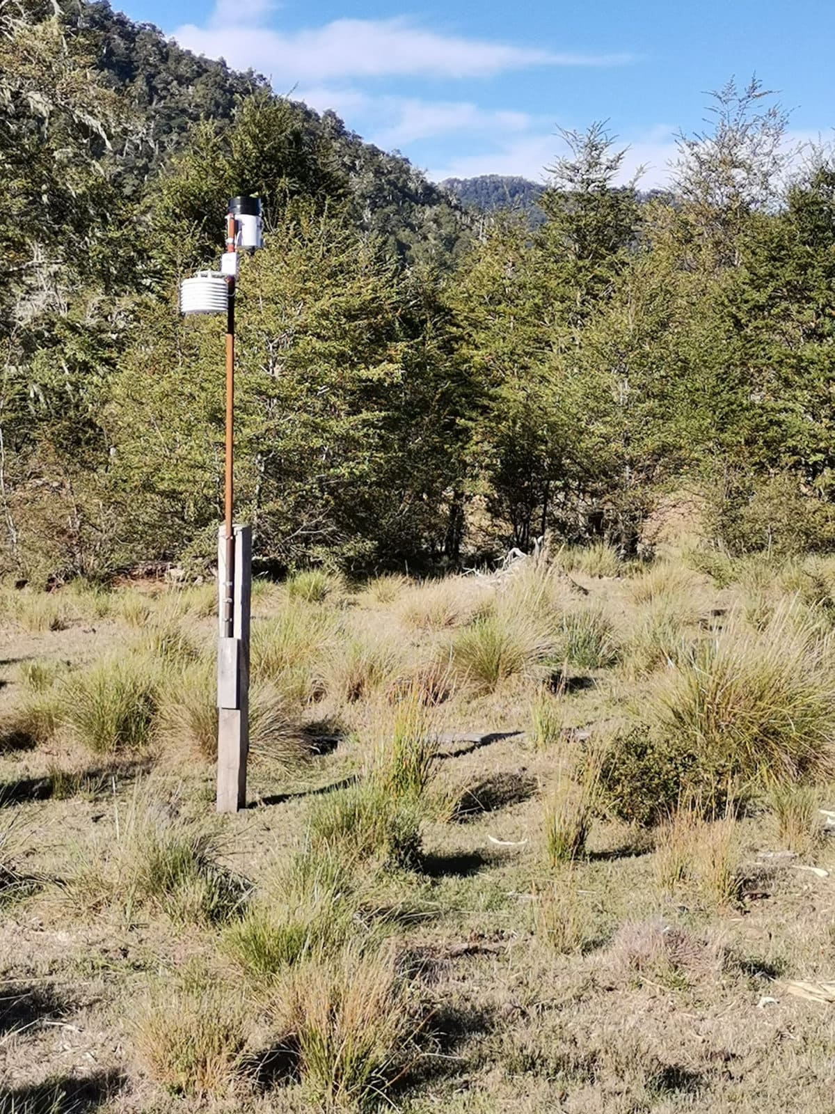
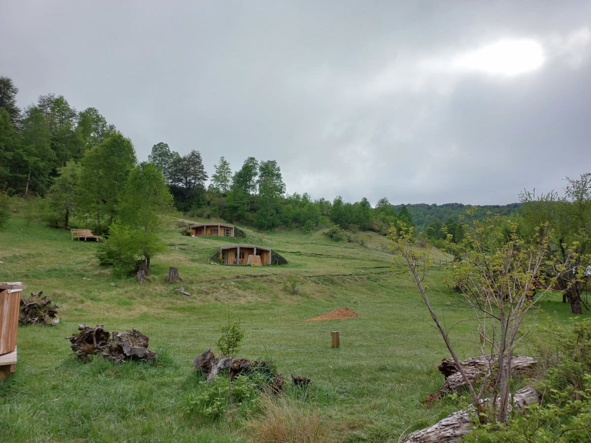
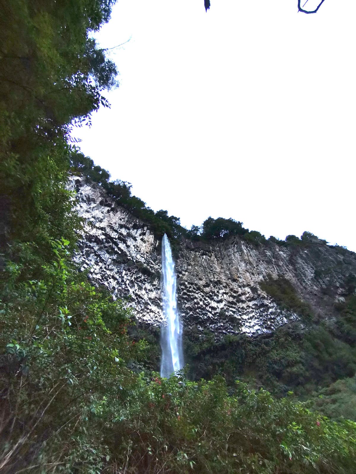
Description
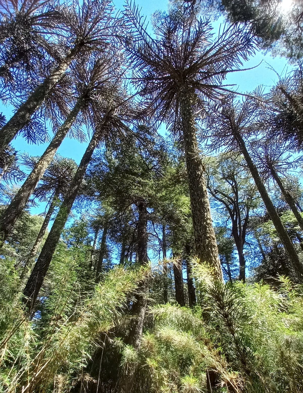
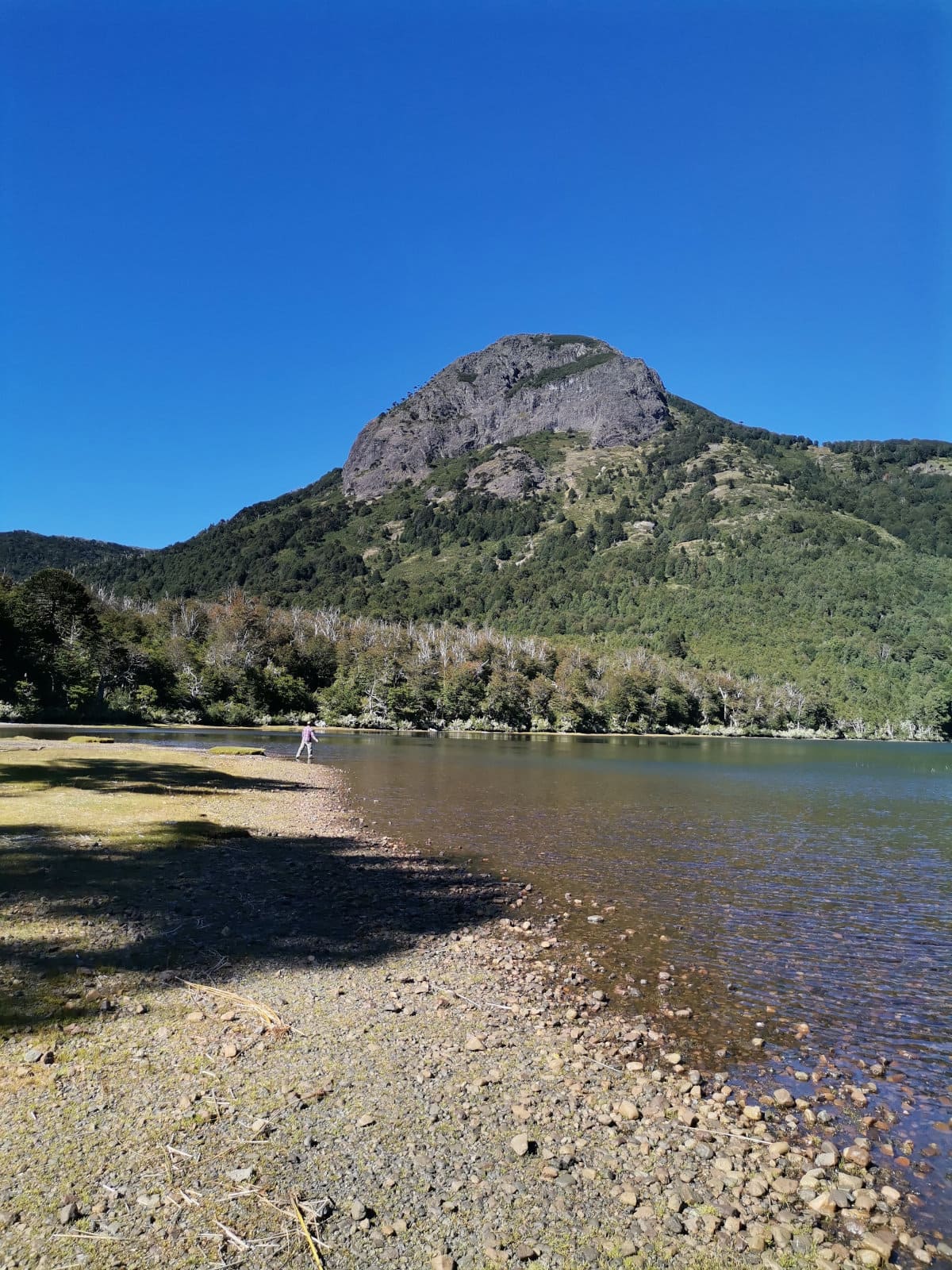
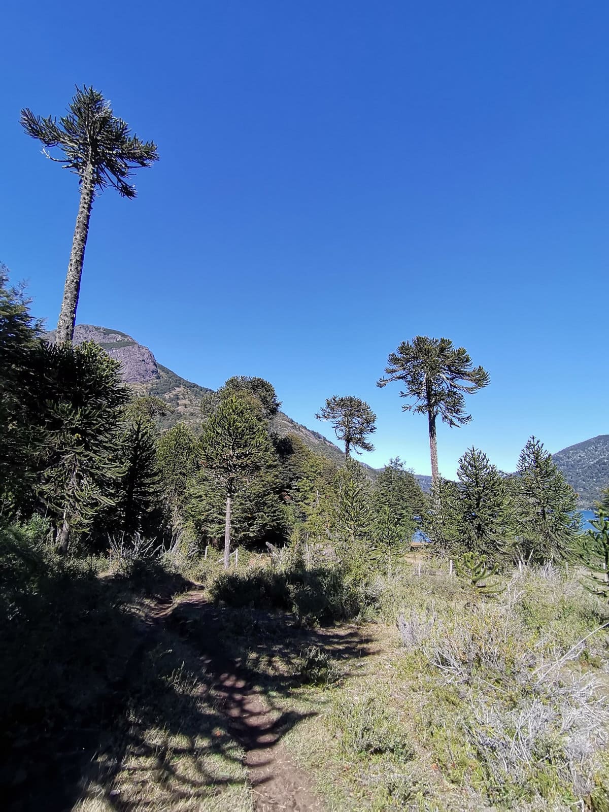
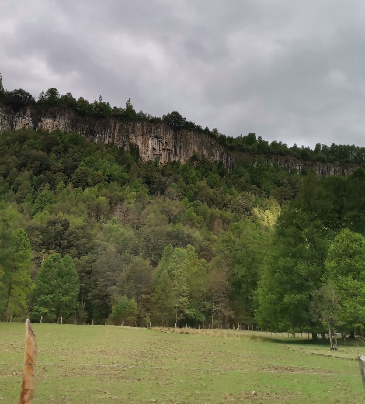
The Trancura River Sub-basin, Before Llafenco, is located in the Araucanía Region and is a tributary of the Toltén River Basin. This watershed has elevations ranging from 353 to 3740 m.a.s.l. The contributing area of this basin is delineated by the Trancura River Station Before Llafenco (RTL) (BNA code 9414001) and is characterized by extensive forest coverage at the foot of the Andes mountains (DGA, 2011).
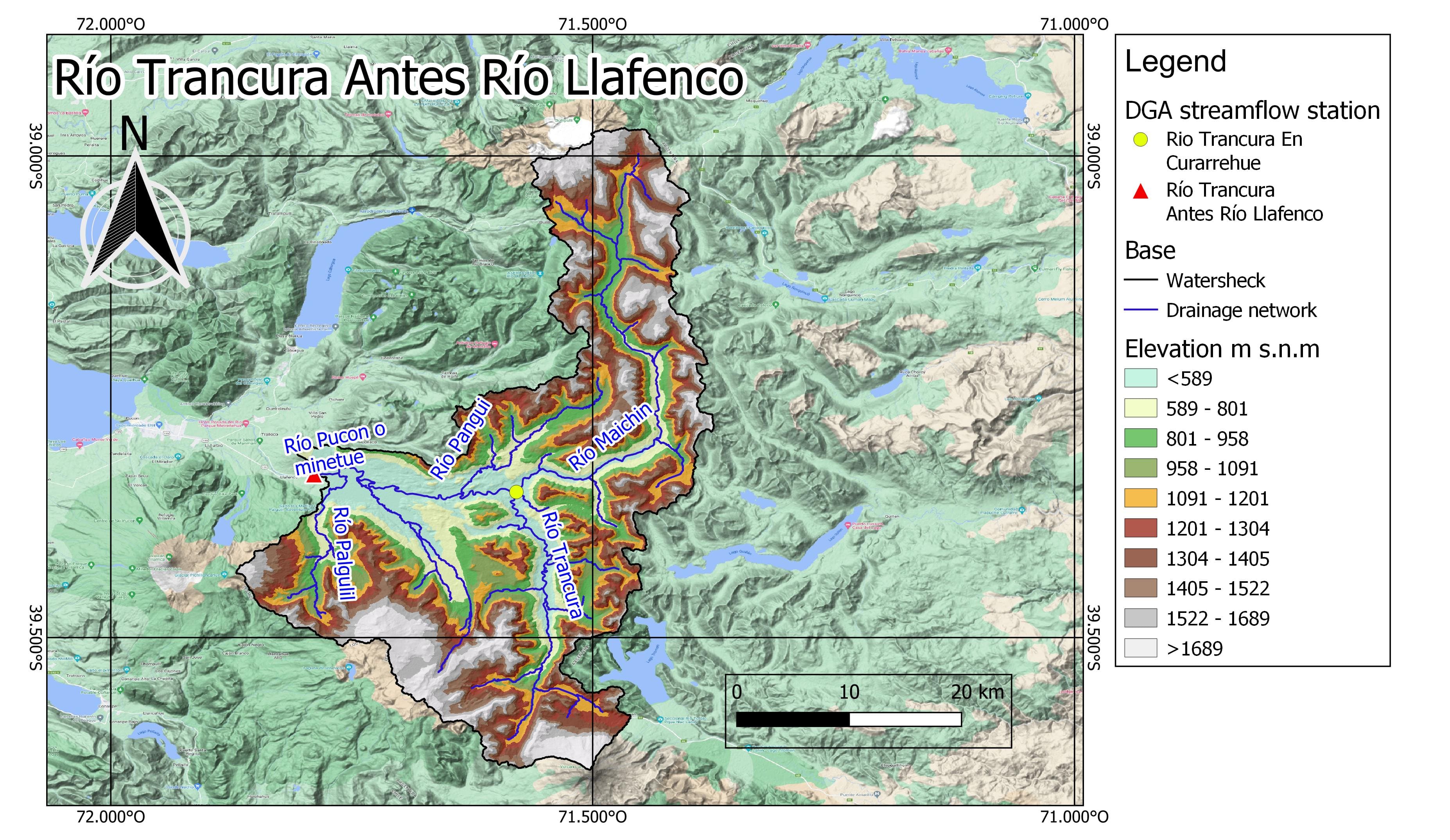
Figure 1. Elevation Map of the Trancura River Basin Before Llafenco.
Regarding the Trancura River Sub-basin In Curarrehue, it covers an area of 224 km², with elevations ranging from 407 to 3389 m.a.s.l.
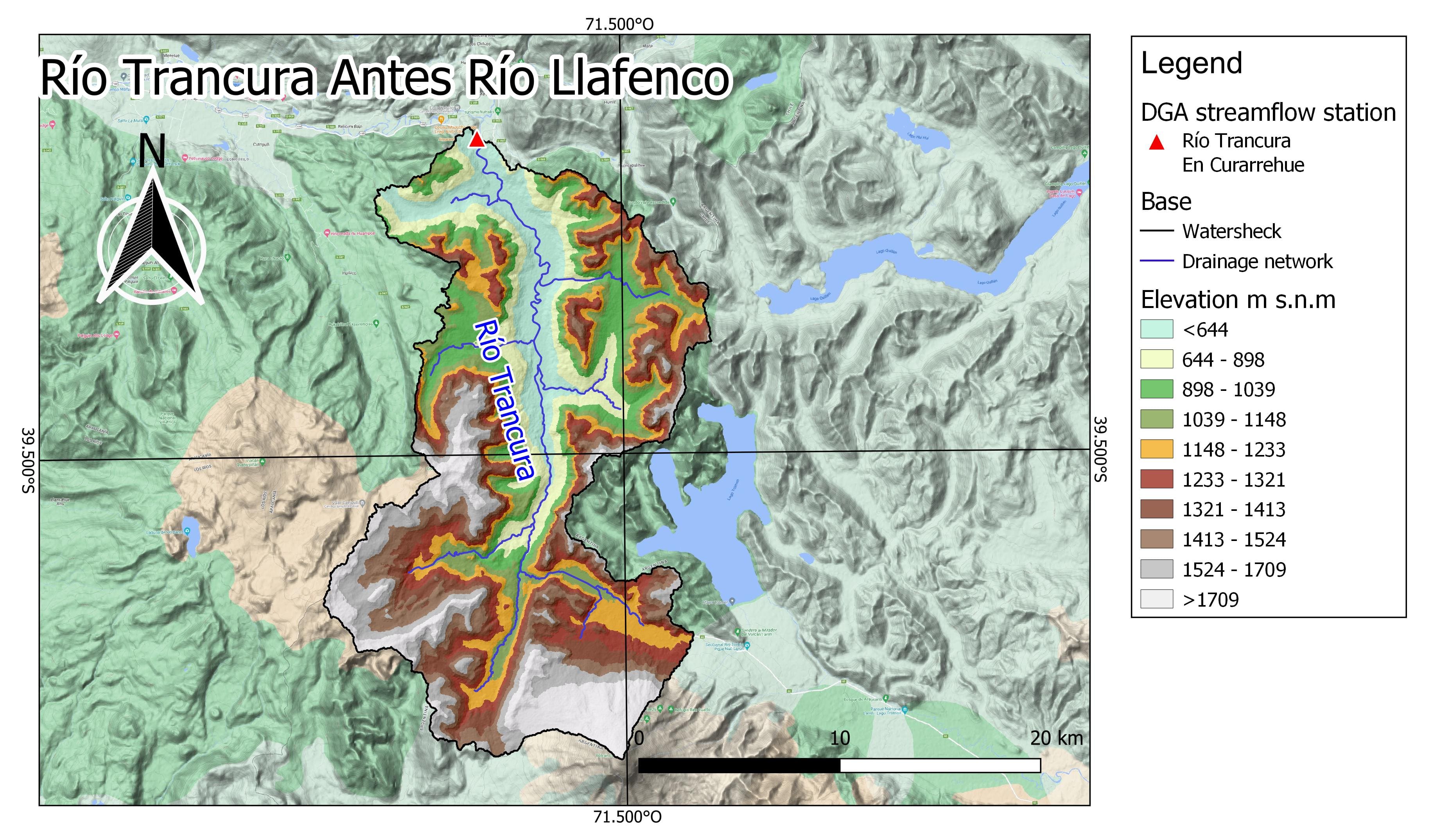
Figure 2. Elevation Map of the Trancura River Basin In Curarrehue.
The basin and sub-basin exhibit a pluvio-nival hydrological regime (DGA, 2004), combining both snow accumulation and rainfall throughout the year. This interaction between climatic factors results in a characteristic flow pattern with seasonal variations. During the spring season, especially in September, October, and November, there is a marked increase in river and stream flows within the basin. This increase is mainly due to the melting of accumulated snow in the mountainous regions during winter, contributing a substantial amount of water to the watercourses, resulting in noticeably higher flows.
Conversely, during the winter season, covering the months of June, July, and August, there is an increase in rainfall. Despite abundant rains during this period, flows in the basin tend to be relatively lower compared to spring, as the main contribution comes from the snowmelt process in the mountains. As the summer season approaches, rainfall tends to decrease, and the basin experiences a gradual reduction in rains. However, flows continue to increase due to the constant snowmelt, contributing to the steady flow of water in the rivers and streams of the basin.
Climate
The Köppen-Geiger Climate Classification identifies this area with temperate climates without dry seasons in the lower areas and dry summers in the higher elevations. According to CR2MET v2 data for the period 1979-2020, this basin experiences precipitation throughout the year, reaching peak amounts between May and August, with values ranging between 380 and 480 mm/month. This results in an average annual flow of 106.8 m3/s, according to the fluviometric station. The average temperature ranges from 3°C in winter to 14°C in summer.
In the context of the Trancura River Basin Before Llafenco, the following climate types have been identified for the present and future periods:
- Cfb: Temperate, without a dry season, with warm summers. In this climate type, there is no defined dry season, and temperatures are generally milder. Summers are warm, but not as dry as in Csa or Csb climates. Precipitation is more evenly distributed throughout the year. This climate is common in areas with moderate oceanic influence.
- Cfc: Temperate, without a dry season, with cool summers. Similar to the Cfb climate, but with cooler summers instead of warm ones. Although there is no defined dry season, temperatures are more moderate, and precipitation remains relatively constant throughout the year. It can be found in areas with both oceanic and continental influences.
- Csb: Temperate, with dry and warm summers. Similar to the Csa climate, this type has dry and warm summers, but temperatures may be a bit more moderate. The rainy seasons are concentrated in winter, and drought is more pronounced in summer. This climate is common in coastal regions with maritime influence.
- Csc: Temperate, with dry and cool summers. In this climate, summers are dry and cool instead of warm. Temperatures may be more moderate year-round, and precipitation is more abundant in winter and scarce in summer. It is characteristic of areas where oceanic influence is less pronounced.
- Dfc: Cold, with dry and cool summers. In this climate, summers are short, dry, and cool. Temperatures are cold throughout the year, and precipitation is low. It is characteristic of cold regions with long, very cold winters.
- Dsb: Cold, with dry and warm summers. This climate is typical of cold regions where summers are short, dry, and warm compared to other seasons. Precipitation is more frequent during the winter. It is common in continental areas with long, cold winters.
- Dsc: Cold, with dry and cool summers. Similar to the Dsb climate, but with cooler summers instead of warm ones. Precipitation is low year-round, but summers are brief and not as warm as in Dsb climates. This type of climate is found in cold areas with maritime influence.
- ET: Polar, tundra. This climate is found in polar regions and is characterized by extremely low temperatures year-round. Summers are very short and cold, and the predominant vegetation is tundra, consisting of low-growing plants adapted to the cold climate . Precipitation is scarce throughout the year, mainly as snow or ice.
These climate categories are fundamental for understanding and describing the various characteristics of the region’s climate, both in the present and in future projections. The analysis of climate trends is essential for decision-making in planning and adaptation to potential changes in the climate.
Figure 3. Köppen-Geiger climate classification map of the Trancura Basin Before Llafenco for the present period (1980–2016) and future period (2071-2100). Source: Beck et al., 2018.
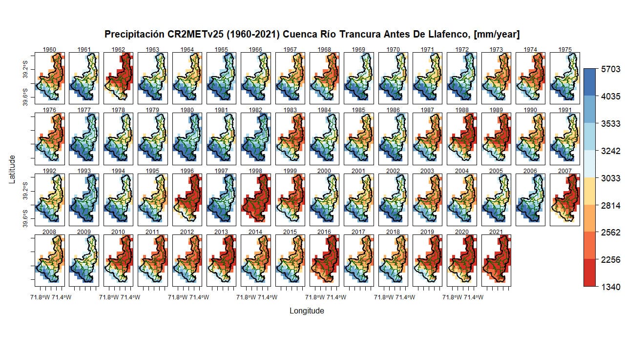
Figure 4. Annual precipitation (1960-2021) in the Trancura River Basin Before Llafenco.
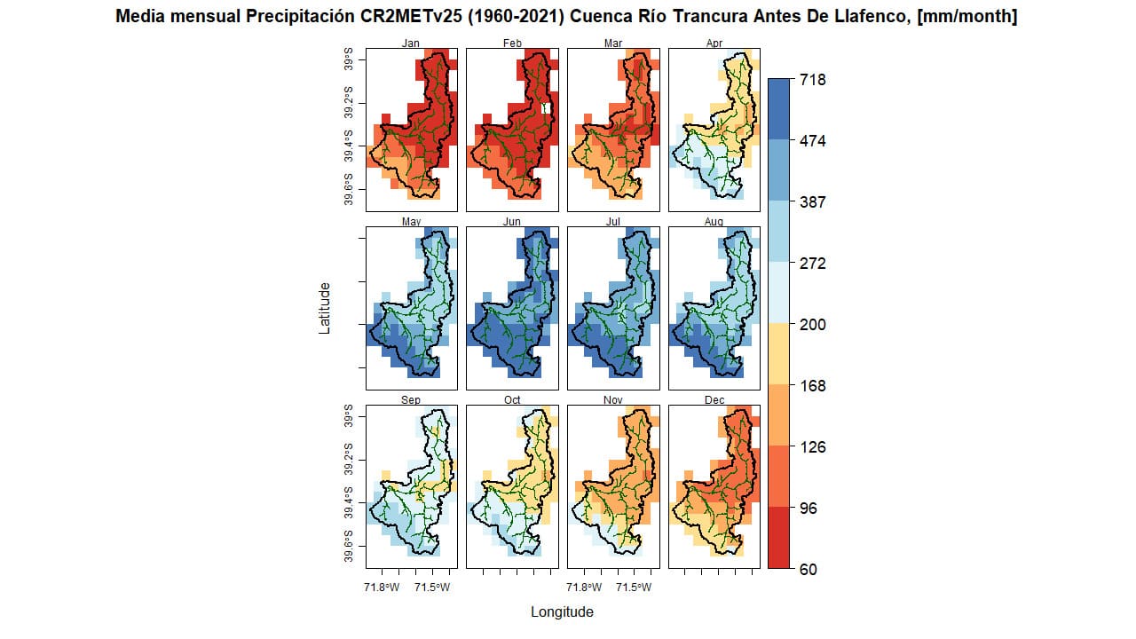
Figure 5. Average monthly precipitation (1960-2021) in the Trancura River Basin Before Llafenco.
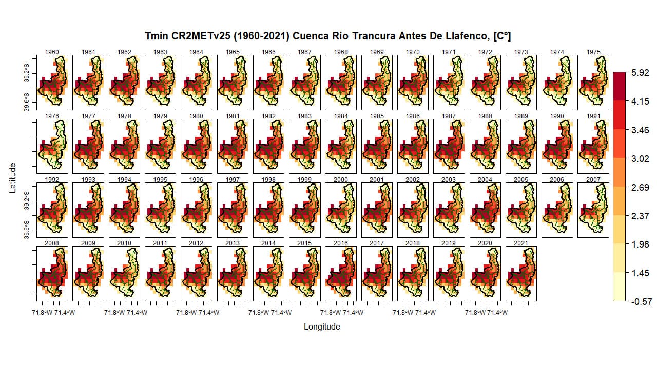
Figure 6. Annual minimum temperature (1960-2021) in the Trancura River Basin Before Llafenco.
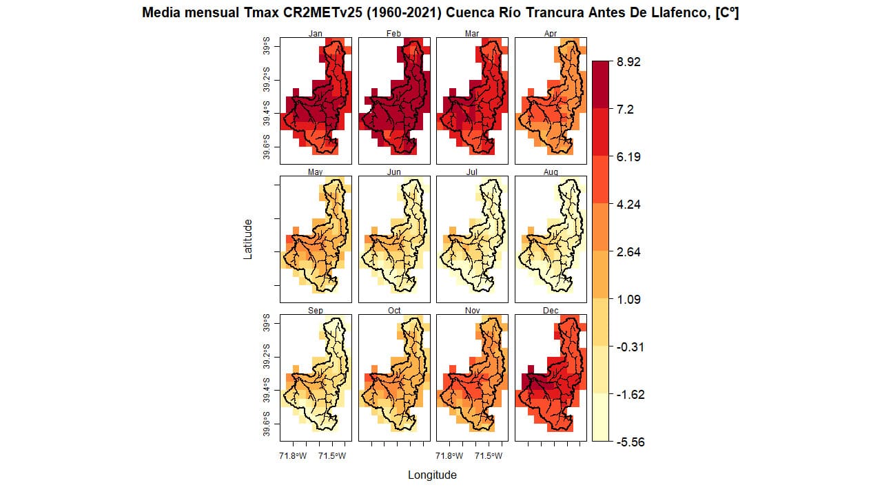
Figure 7. Average monthly minimum temperature (1960-2021) in the Trancura River Basin Before Llafenco.
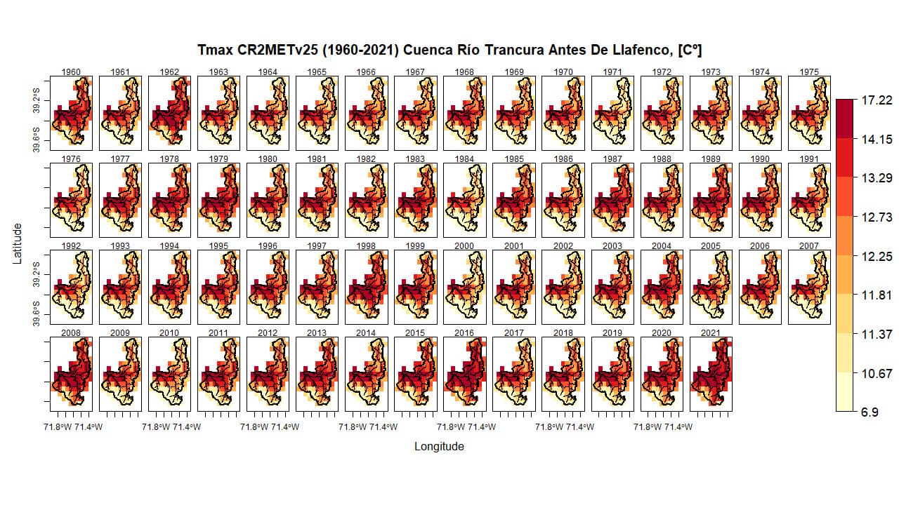
Figure 8. Average annual maximum temperature (1960-2021) in the Trancura River Basin Before Llafenco.
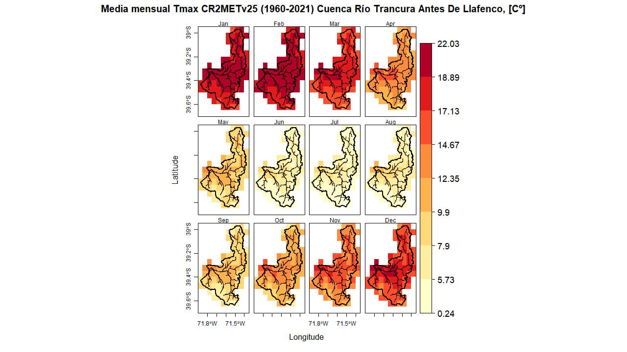
Figure 9. Average monthly maximum temperature (1960-2021) in the Trancura River Basin Before Llafenco.
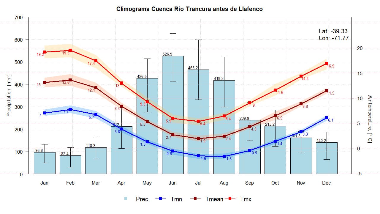
Figure 10. Climograph of the Trancura River Basin Before Llafenco. Based on CR2METv2.5 data.
Land Use
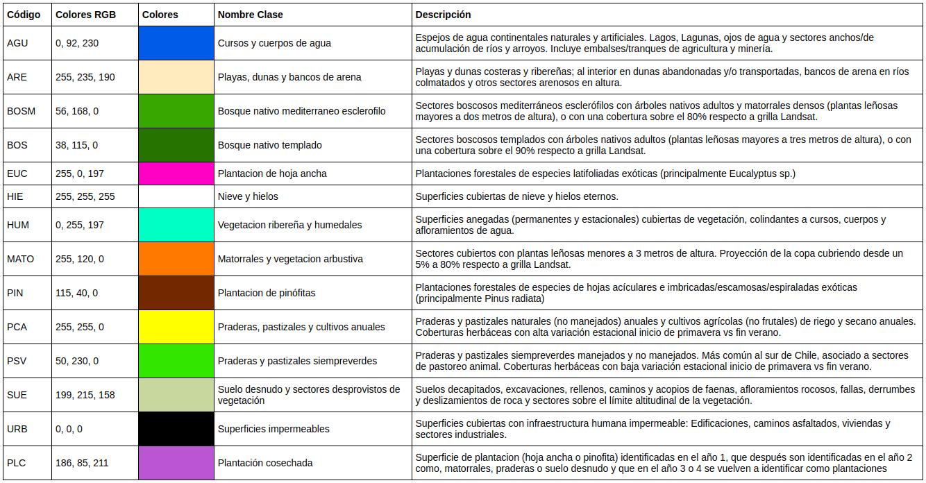
The main land uses in the RTL sub-basin consist primarily of native forests, with rock/snow coverage in the higher elevations and grasslands in the floodplains, indicating that human intervention can be considered minimal (Land Cover of Chile 2014).
Figure 11. Land use map of the Trancura River Basin Before Llafenco. Source: Ceballos et al. (2021) y Galleguillos et al. (2024).
Table 1. Descriptive table of land cover in the Trancura River Basin Before Llafenco.
Geology
The rocks in this area are mixed and come from volcanic sequences (48%), intrusive rocks (30%), and volcano-sedimentary sequences (14%) (DGA, 2011).
Water Resources
Monitoring Points
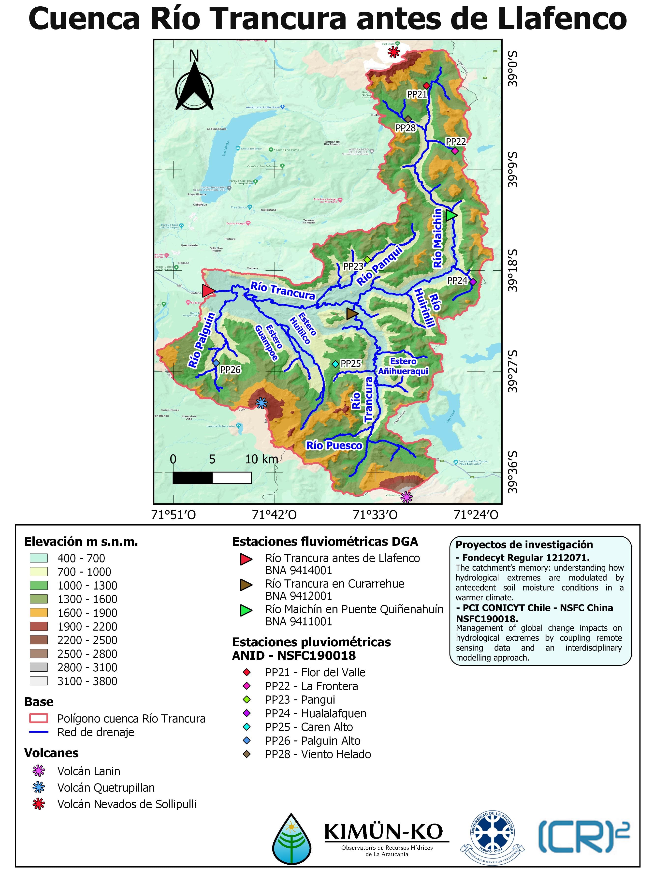
Figure 12. Precipitation monitoring points.
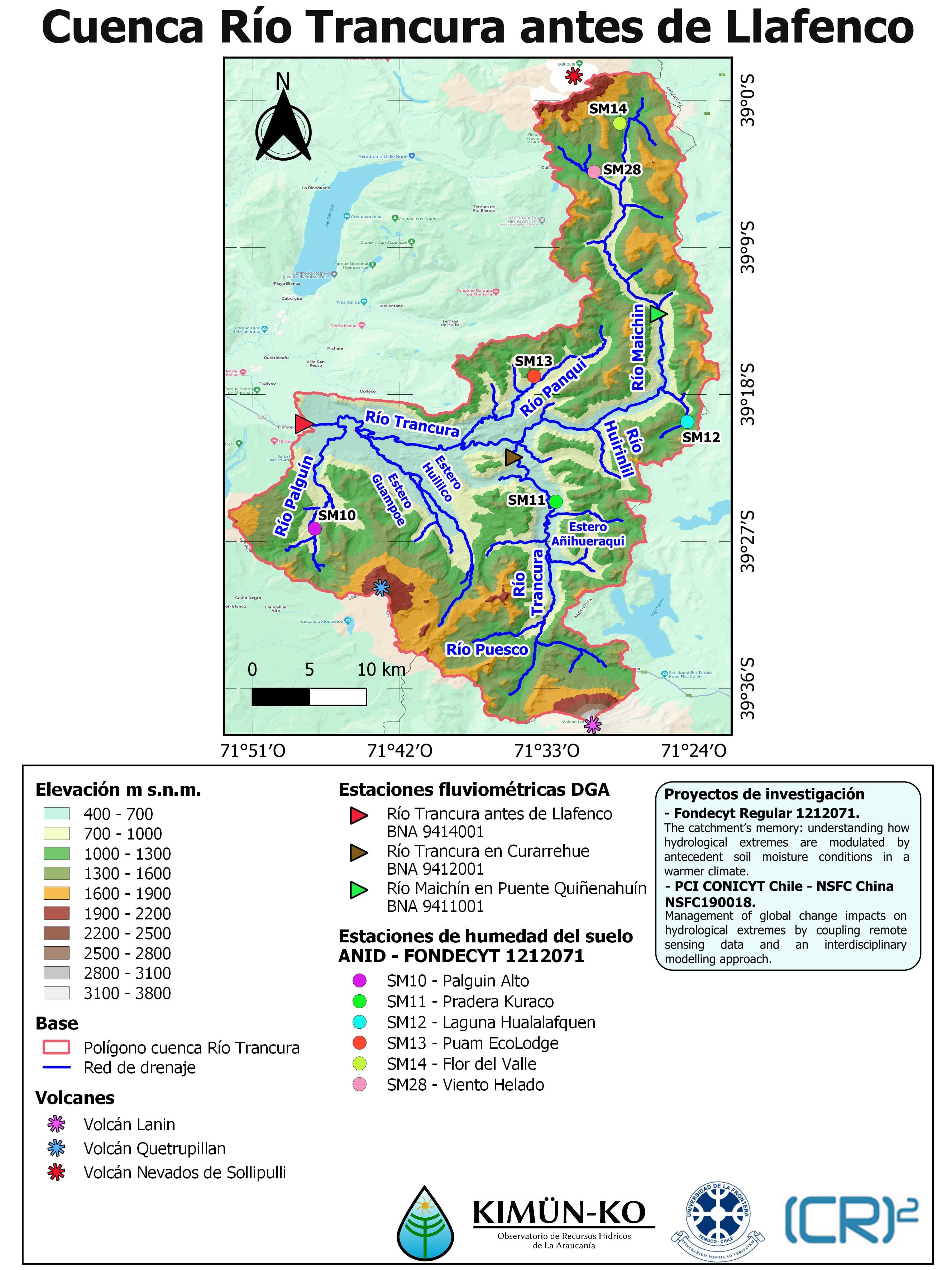
Figure 13. Soil moisture monitoring points.
Intensity-Duration Curves of Precipitation
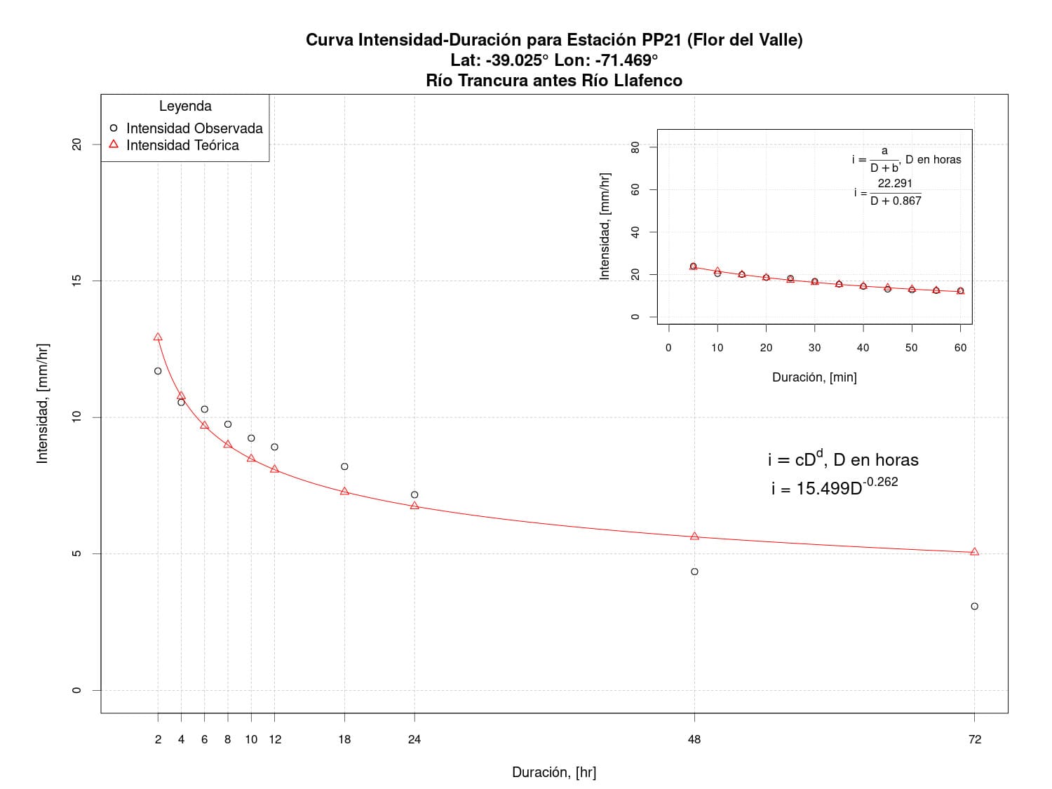
Figure 14. Intensity-Duration Curve for Flor del Valle Station (PP21).
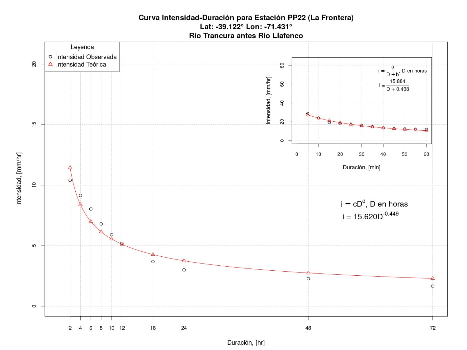
Figure 15. Intensity-Duration Curve for La Frontera Station (PP22).
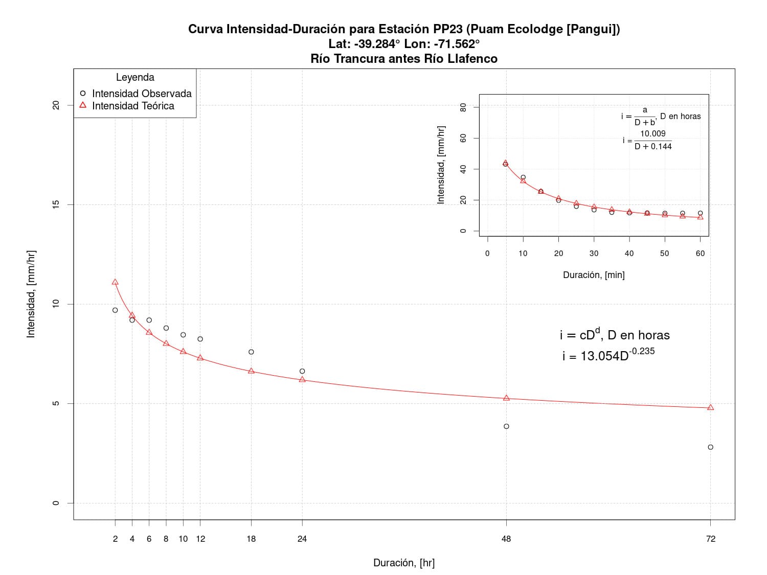
Figure 16. Intensity-Duration Curve for Puam Ecolodge (Pangui) Station (PP23).
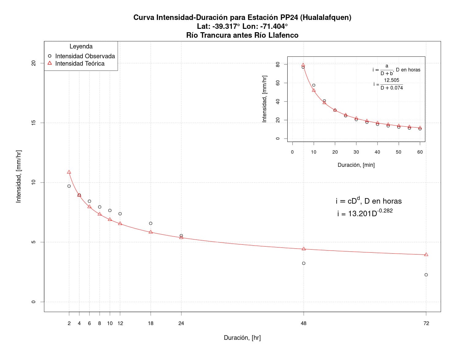
Figure 17. Intensity-Duration Curve for Hualalafquen Station (PP24).
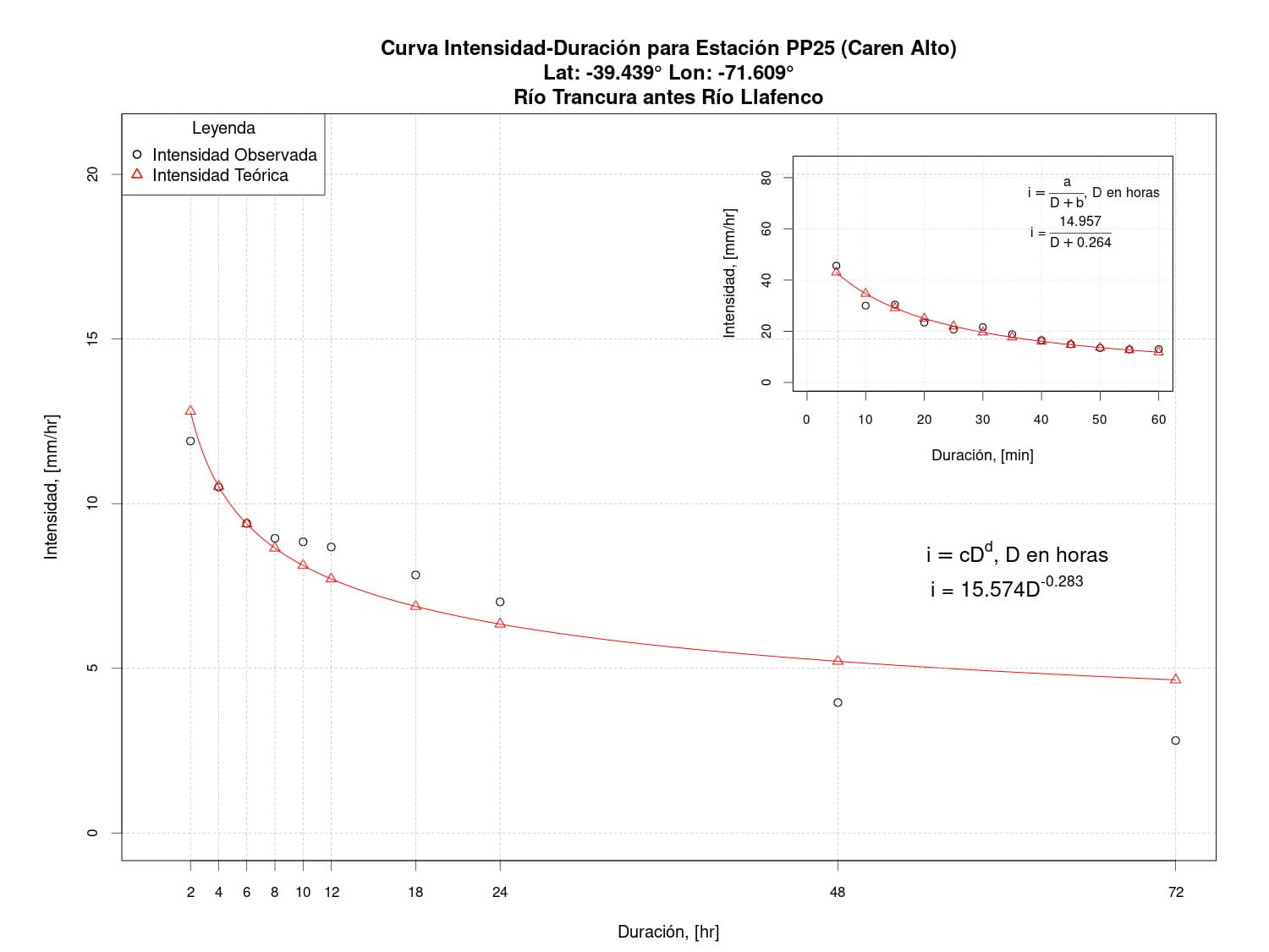
Figure 18. Intensity-Duration Curve for Caren Alto Station (PP25).
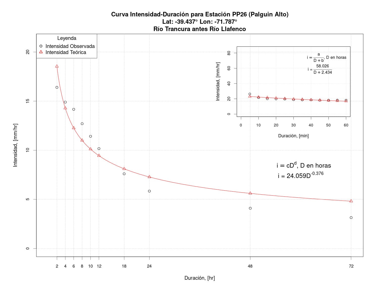
Figure 19. Intensity-Duration Curve for Palguin Alto Station (PP26).
Water Rights
The Trancura River, a vital watercourse flowing through the Chilean landscape, plays a crucial role in supporting communities and ecosystems along its path. Specifically, the area Before Llafenco has witnessed constant interaction between humans and this water resource, leading to the formulation and recognition of Water Rights for the Trancura River in this area. Water rights are legal and regulatory tools that govern the allocation and use of water resources for the benefit of various users and activities. In the context of the area Before Llafenco, these rights are particularly significant, as they establish the amount and manner in which water from the Trancura River can be used for activities such as agricultural irrigation, human consumption, industrial activities, and other purposes. Below are the surface and underground water rights for the study basin.
Relevant references:
- Municipalidad de Curarrehue (2022). Imagen Objetivo - Actualización Plan Regulador Comunal de Curarrehue. Estudio Plan Regulador Comunal.
- Burgos, B. (2021). Evaluación del impacto del cambio climático en el caudal de salida de una subcuenca del Río Trancura, en base a proyecciones climáticas globales de alta y súper alta resolución. Biblioteca Digital de la Universidad de La Frontera.
- Oyarce Avilés, C. (2020). Periurbanización y amenazas del paisaje lacustre: hacia nuevos pasajes-paisajes de desarrollo sostenible en la conurbación Villarrica-Pucón. Tesis para optar al título de Magíster en Proyecto Urbano. Pontificia Universidad Católica de Chile. Escula de Arquitectura. Snatiago, Chile. Julio 202.
- Garin, A.; Quinteros, B. (2020). Caracterización de los emprendedores y su percepción. PASOS Revista de Turismo y Patrimonio Cultural.
- Ceballos-Comisso, A.; Galleguillos, M.; Gimeno, F.; Lara, A. (2021). A semi-automatic algorithm for historical Land Cover Mapping in a complex dynamic landscape of central Chile. Technical report.
- Galleguillos, M., Ceballos-Comisso, A., Gimeno, F., & Zambrano-Bigiarini, M. (2024). CLDynamicLandCover [Data set]. Zenodo. https://doi.org/10.5281/zenodo.13153631
- Chiguailaf, C. (2019). Creación de un prototipo de sistema de alerta temprana para inundaciones a escala diaria para la subcuenca del Río Trancura en Curarrehue, Región de La Araucanía. Biblioteca Digital de la Universidad de La Frontera.
- Municipalidad de Pucón (2019). Plan maestro de desarrollo territorial sustentable Pucón. Informe Etapa 1. Análisis Territorial Integrado. Agosto 2019.
- Escobar Valdivia, M. (2019). Identificación de regiones contaminadas en la superficie del Lago Villarrica con base en imágenes Sentinel, en el período 2017-2018. Proyecto de título para obtener el título de Ingeniero Geomético. Universidad de Concepción. Departamento de Ciencias Geodésicas y Geomética. Los Ángeles, Chile. Marzo 2019.
- Bruning González, M. B. (2018). Estudio de aporte de carga de nutrientes por fuentes contaminantes y análisis de escenarios de descontaminación mediante un modelo de calidad de aguas en el Lago Villarrica. Memoria de título para optar al título de Ingeniera Civil Química. Universidad de Chile. Departamento de Ingeniería Química, Biotecnología y Materiales. Santiago de Chile.
- Huiliñir-Curío, V. (2018). De senderos a paisajes: paisajes de las movilidades de una comunidad mapuche en los Andes del sur de Chile. Chungará (Arica), 50(3), pp.487-499. doi:10.4067/S0717-73562018005001301.
- Jerez, J.; Jerez, A.; Aguayo, M. (2018). El indómito Trancura. Ambiente 6 (2018), 43–41.
- Peralta, C. (2017) Conflicto etno-ambiental en el marco de la Consulta Indígena. Revista Estudios de Políticas Públicas, 3(2), 161-178. doi:10.5354/0719-6296.2017.47756
- Municipalidad de Pucón (2016). Actualización Plan Regulador Comunal de Pucón. Capítulo III. El Soporte físico del Territorio. I Etapa: Expediente Urbano Comunal. Enero 2016.
- TECO Group y Centro UC CAmbio Global (2016). Análisis de las condicionantes para el desarrollo hidroeléctrico en las cuencas del Maule, Biobío, Toltén, Valdivia, Bueno, Yelcho y Puelo, desde el potencial de generación a las dinámicas socioambientales. Licitación N° 584105-23-LP15 Grupo de cuencas 1: Maule, Biobío y Toltén. Preparado para Subsecretaría de Energía. División de Desarrollo Sustentable, Santiago, Chile. Diciembre 2016.
- DGA (2010). Aplicación de modelación superficial en cuencas pluviales de las regiones del Maule, Bio Bío y la Araucanía. Realizado por la División de Estudios y Planificación. S.D.T. 302. Santiago, Septiembre 2010.
- García, C. (2010). Cazadores recolectores en el Sur de Chile: aproximaciones desde el área Lacustre Andina. Werken, 13, pp.347-358.
- DGA (2009). [Levantamiento de parámetros para la modelación hidrológica de cuencas pluviales no controladas en la IX Región de la Araucanía]https://snia.mop.gob.cl/sad/SUP5226.pdf). Realizado por RODHOS Asesorías y Proyectos Ltda. S.I.T. 199. Santiago, Diciembre 2009.
- Forero, O. (2011) Digital technology uses for sustainable management of natural resources in multicultural contexts. Development in practice, 21(6), 822-833. doi:10.1080/09614524.2011.582858
- DGA (2004). Diagnóstico y clasificación de los cursos y cuerpos de agua según objetivos de calidad. Cuenca del Río Toltén. Realizado por la Cade-Idepe COnsultores en Ingeniería. Dirección General de Aguas. Santiago, Diciembre 2004.
Related videos:
- Curarrehue Visión (2021). Curarrehue 40 Años. Feb, 3, 2021.
- Canal 13 (2016). Capítulo 13 - Lugares Que Hablan Temporada 2019. Jun, 12, 2019.
- TVN (2019). Lleve de lo bueno - E5: Curarrehue. Oct, 11, 2016.
- Carlos Valera (2022). Otoño en Curarrehue - Chile 4K. May, 11, 2022.
Related news:
- Cooperativa (2022). Sistema frontal genera problemas en diversas comunas de La Araucanía. Jun, 29, 2022.
- Chile Travel (2022). Ríos de Chile: 4 panoramas imperdibles en La Araucanía. May, 12, 2022.
- Guzmán, G. (2010). Alcalde de Curarrehue exige que gobierno solucione problemas de inundaciones en la zona. Jun, 25, 2010.
- La Tercera (2019). La Araucanía: Desborde de Río Trancura deja ocho mil personas aisladas y obliga a suspender el tránsito. Jul, 31, 2019.
- Pauta (2019). El costo urbano de los destinos turísticos en temporada estival. Ene, 29, 2019.
- La Tercera (2018). Sistema frontal mantiene a 656 personas aisladas en La Araucanía. Jul, 1, 2018.
- La Tercera (2014). Más de 6 mil personas se encuentran aisladas por desbordes de ríos en La Araucanía. Ago, 2, 2014.
- Chile Sustentable (2015). Caen 2 proyectos hidroeléctricos en Curarrehue y Pucón. Abr, 30, 2015.